| Undersea Exploration Tools
During the 2005 Hunt for the Alligator, researchers will deploy an IXSEA Global Acoustic Positioning System (GAPS). The system allows researchers to track the underwater position of up to eight remote sensing tools, including magnetometers, side scan sonar towfish, remotely operated vehicles, autonomous underwater vehicles, and even divers. GAPS integrates GPS (Global Positioning System), USBL (Ultra Short Base Line), and INS (Inertial Navigation System) in one unit and eliminates the need to synchronize and calibrate multiple pieces of equipment. Because GAPS is a portable, all-in-one, plug-and-play system, it can be used anywhere and is fully operational within minutes of installation.
The 2005 search team will use an IXSEA Magis high-resolution marine magnetometer to hunt for the Alligator. A magnetometer is a passive device that can detect concentrations of ferrous material, such as iron anchors, cannon, or ships’ fittings, all of which produce a variation, or anomaly, in the earth’s magnetic field. This makes magnetometers a highly useful tool for shipwreck hunts and studies. However, a magnetometer must be towed relatively close to the object to detect it. As a rough guide, a large steel wreck can be detected at a range of 120 to 180 meters; a site with iron anchors and cannon at 80 to 100 meters; and an isolated cannon at 30 meters. Remotely Operated Vehicle
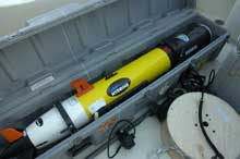
REMUS Unmanned Underwater Vehicle
During the 2005 Hunt for the Alligator, technicians from the Naval Surface Warfare Center Panama City will deploy a sensor-equipped unmanned, autonomous underwater vehicle in the 2005 Alligator search area. The torpedo-shaped Remote Environmental Monitoring UnitS, or REMUS, is a low-cost vehicle developed at the Woods Hole Oceanographic Institute. Originally designed to conduct coastal surveys in support of science, it was adapted for military use with support from the Office of Naval Research and the U.S. Special Operations Command. Capable of performing rapid environmental surveys, REMUS also functions as an underwater mine reconnaissance device for the Navy’s Mine Countermeasure program. REMUS’s compact size allows for one-man deployment and operation. Weighing only 82 pounds and just over 5 feet in length, it can operate at speeds of 3-5 knots for up to 22 hours, at a depth of up to 300 feet. REMUS is equipped with an array of sophisticated sensors, navigational aides, and power resources. It navigates underwater using one of three methods: Long Base Line, Dead Reckoning, or Ultra-Short Base Line. An onboard computer automatically determines the preferred method of navigation and is capable of changing methods throughout the mission for optimal performance. Once launched in its standard configuration, REMUS will carry out its pre-programmed mission, collecting valuable sonar and other data that will give archaeologists a picture of objects on the sea floor. For more see: |
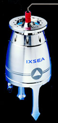 Global Acoustic Positioning System
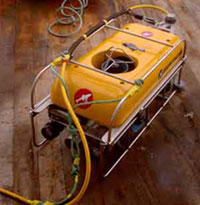 To get a closer look at, or “ground-truth,” anomalies identified by the magnetometer, the 2005 Hunt for the Alligator expedition team will use a remotely-operated vehicle (ROV). An ROV is a vehicle or platform that is placed in the water and controlled from the ship. ROVs can be fitted to include sample collectors, manipulator arms, video and still cameras and lights. ROVs are generally powered by thrusters, providing directional control. For the 2005 search, the team will use a Benthos ROV, which will use its own propulsion system to acquire images of any magnetic contacts. The Benthos ROV is equipped video camera and lights to facilitate small or large object identification.