Error processing SSI file
|
The Mission
Alaska accounts for more than half the ocean coastline of the United States. Home for thousands of years to indigenous maritime Aleut, Eskimo, and coastal Indian cultures, Alaska and its people, past and present, have inextricable links with the sea. A longstanding source of food and clothing and, in historic times, a place of economic opportunity, Alaska’s coastal waters provide critical transportation links and function as conduits of social and cultural exchange. Alaska is also home to an enormous and diverse array of submerged cultural resources: more than 3000 shipwrecks and yet uncounted industrial and prehistoric sites.
 |
|
The Legend in front of the Eldred Rock Lighhouse (Photo: Hans Van Tilburg)
|
Lacking a dedicated marine archaeology program, the State of Alaska has created partnerships with federal agencies, universities, divers, and individual scholars in order to study and better preserve the state’s submerged and maritime history. NOAA has been a major contributor to these efforts. In 2004, the Office of Ocean Exploration (OE) funded the expedition that identified the wreck Kad’yak , the oldest vessel yet found from the Russian-American Period. In April 2006, a multidisciplinary expedition also funded by OE, the Lynn Canal shipwreck Project which examined five shipwrecks in Southeastern, Alaska. While preparing for that project the team became aware of the original identity of the Clara Nevada and began to understand the historical significance of the Hassler.
The vessel is a popular subject of Alaskan lore and is vulnerable to site disturbance. The archaeological remains of the Hassler are considered to be one of the most significant submerged heritage sites in the modern history of Alaska and in the evolution of the Coast Survey as a federal agency dedicated to oceanic and coastal research. An innovative ship with a rich history as a science and survey vessel, the Hassler was considered an excellent project for commemorating the Two Hundredth Anniversary of the U.S. Coast Survey, founded in 1807.
The Principle Goals for the 2007 Hassler Expedition
 |
|
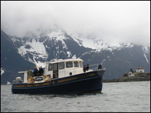
The baseline running next the Hassler’s propeller shaft (Photo: Tane Casserley)
|
The 2007 Hassler expedition had accomplished several goals including determining the boundaries of the wreck site, assessing the site’s stability, documenting diagnostic architectural details through still and video photography and manual sketching, studying the wreck as a feature of a larger maritime cultural landscape of the Eldred Rock Lighthouse, promoting the preservation of maritime heritage resources through public outreach, and compiling sufficient data to support the nomination of the wreck to the National Register of Historic Places.
Tools, Techniques, and Challenges
The wreck of the Hassler lies in one the most exposed places in Southeastern Alaska. High winds from the north and south are common. On the night the ship was lost, estimates placed the winds at over eighty knots. The wind comes up quickly—often with little warning and brings sharp seas with it. Lurking below the surface, the rock that claimed the Hassler has not lost its knife like edges. Furthermore, the tides and currents are notoriously unpredictable. In simple terms, the Hassler rests in a place of spectacular beauty but constant danger. During the 2006 expedition, the archaeologists had a brush with what Eldred Rock has to offer and considered themselves lucky to have escaped unscathed. During the 2007 survey, however, the team enjoyed better than average weather and lost but one afternoon to high winds.
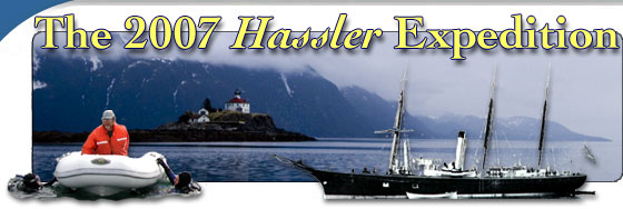
A key to success in 2007 was a solid and surprisingly nimble research platform, the 42 foot Legend, a staunch craft built by Nordic Tug, owned and skippered by Dave Carnes, a 35 year veteran of the commercial salmon fishery in Southeastern Alaska. Equipped with a rigid inflatable launch and ample bunks, the Legend proved both capable and comfortable. The vessel’s large swim platform and bow thruster made deploying divers and the team’s small ROV (remotely operated vehicle) safe and simple.
 |
|
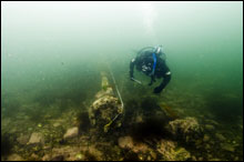
NOAA Archaeologist Tane Casserley Launches the Seabotix ROV (Photo: Hans Van Tilburg)
|
Over a period of four days, archaeologists laid down a central baseline and made multiple dives to the wreck and surrounding area, documenting the site with video, still digital cameras and basic sketch mapping techniques. The depth of the water over the site ranged between 10 and 30 feet. This allowed for long dives and the collection of a surprising amount of visual data. Water temperatures of 41 degrees required the use of drysuits, which, however, proved only barely adequate for keeping the cold water at bay. The visibility ranged from seven to as much as 25 feet. This depended on the stage of the tide and the particular section of the site being documented. The hazardous rock and the reef complex it connects with provide a partial shield from the strong currents, but at the cost of visibility. The NOAA Seabotix ROV was launched on several occasions to conduct visual reconnaissance surveys, document the site with video, and take the brunt of the punishing cold water when the divers couldn’t take any more.
The 2007 Hassler Expedition collected significant amounts of new data and developed a vastly enhanced understanding of the wreck and its natural and cultural surroundings. Although the 2007 diving portion of the project is complete, the project itself will continue later this summer when the NOAA Ship Rainier will conduct side-scan and multi-beam sonar surveys of the area. Future plans include nominating the site to the National Register of Historic Places.
|