Error processing SSI file
Previous Missions to Titanic
In the immediate aftermath of the sinking, proposals to locate the sunken Titanic were discussed and ultimately dismissed because the wreck lay well beyond the limits of technology at that time. Through the decades, the development of subsea technology finally provided the means to locate the wreck and subsequently to not investigate it using remote technology, but also to dive to the wreck and conduct a series of investigations that included surveys of the interior of the ship. The dramatic changes in the technology utilized to try and find the wreck is epitomized by the late July -early August 1953 attempt by salvage firm Risdon Beazley Ltd. and the ultimately successful mission in September 1985 by Woods Hole and IFREMER. Risdon Beazley detonated explosives and plotted the echo with sonar to obtain a bottom profile. The Woods Hole/IFREMER mission deployed a towed deep sea survey vehicle equipped with sonar and cameras.
 Towed arrays to locate Titanic moved to the forefront of search proposals by the late 1970s, and in 1980, the first of three highly publicized searches by Lamont-Doherty Geographic Observatory's William Ryan, funded by Texas oil tycoon Jack Grimm began what would ultimately be an unsuccessful search that continued into 1981 and 1983 of a hundred square nautical mile area in which Titanic had foundered using mid-range side-scan sonar mounted on the vehicles Deep-Tow and Sea Marc I. In July 1985, the IFREMER/WHOI search began, with IFREMER deploying their newly developed side-scan sonar SAR vehicle on a mission led by Jean-Louis Michel on the research vessel Le Suroit. That survey covered 70 percent of a 150 square nautical mile survey box without locating Titanic, but as later analysis would show, they had come very close to the wreck, as indeed had William Ryan earlier. Towed arrays to locate Titanic moved to the forefront of search proposals by the late 1970s, and in 1980, the first of three highly publicized searches by Lamont-Doherty Geographic Observatory's William Ryan, funded by Texas oil tycoon Jack Grimm began what would ultimately be an unsuccessful search that continued into 1981 and 1983 of a hundred square nautical mile area in which Titanic had foundered using mid-range side-scan sonar mounted on the vehicles Deep-Tow and Sea Marc I. In July 1985, the IFREMER/WHOI search began, with IFREMER deploying their newly developed side-scan sonar SAR vehicle on a mission led by Jean-Louis Michel on the research vessel Le Suroit. That survey covered 70 percent of a 150 square nautical mile survey box without locating Titanic, but as later analysis would show, they had come very close to the wreck, as indeed had William Ryan earlier.
Picking up the search in August, the WHOI team, led by Robert Ballard aboard the research vessel Knorr utilized the towed vehicle Argo, with a 100 khz side-scan sonar, and three low-light black and white video cameras. Ballard's team relied on the optical system to locate Titanic, with 24 hour watches and a slow tow to locate and then follow a "debris trail" that Ballard surmised had to be present from the break and sinking of the ship. Just before midnight on August 31, 1985, the first scattered debris from what proved to be Titanic began to appear, and in the early morning hours of September 1, the unmistakable form of a boiler made it clear that the search was over. Titanic's final resting place had been found.
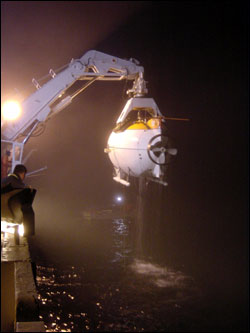
Since the discovery in 1985, a series of expeditions have visited Titanic with a variety of goals. Ballard and Woods Hole returned to the wreck in July 1986 on the WHOI research vessel Atlantis II, with the submersible Alvin, and the ROV Jason Jr. The 1986 expedition photographed and filmed the wreck, focusing on the largely intact bow section. Working from the data collected from the 1985 Argo survey as well as 1986 data, WHOI's William Lange and others assembled a preliminary site map of the Titanic wreck site that delineated the site from the bow to the stern section and plotted a wide range of features scattered on the seabed. A private venture funded and led by RMS Titanic, Inc., the salvor-in-possession of the wreck (RMST), and technically supported by IFREMER, returned to the wreck in July 1987 and made 32 dives to recover some 1,800 artifacts from the seabed, the first of a series of recovery dives made by RMST until 2004 which ultimately salvaged nearly 5,000 artifacts.
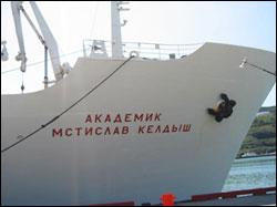
A view of the bow of the Russian Research Vessel Akademik Mstislav Keldysh, which served as the research platform for the expedition to Titanic. |
A June-July 1991 expedition, working with the P.P. Shirsov Institute of Oceanology and deployed from the research vessel Akademik Mstislav Keldysh made a series of dives in the submersible Mir 1 and Mir 2 to film the IMAX movie "Titanica." These dives, like others made by documentary film crews and James Cameron (whose first dives were in 1995, also working with the Shirsov Institute and the Mirs), captured dramatic images of the wreck as well as additional technical information and a more detailed view of aspects of the wreck site. In particular, Cameron's extensive documentation and penetration of the interior of the bow with small ROVs known as "bots" provided incredible insights into the ongoing processes of environmental change and preservation inside the ship, as well as evidence of what had occurred during the sinking of Titanic. Cameron's visits to the wreck provided the visuals for his blockbuster film "Titanic" as well as his documentary "Ghosts of the Abyss" and his soon-to-be released 3D film of the wreck. Cameron's work has arguably done more to share Titanic as a wreck site with a greater audience than anyone else.
Among the scientific products of the various expeditions were detailed analysis of the microbiological corrosion of the ship's steel (led by Roy Cullimore), geological studies of the sediments and current studies (by the Shirsov Institute) a detailed sonar survey of the bow where Titanic struck the iceberg, photo mosaics of the bow section, and forensic studies of the ship's sinking sequence and break-up. As well, RMS Titanic, Inc. commissioned the creation of an "archaeological GIS" map delineating where the 5,000 artifacts had been recovered from between 1987-2004. That GIS, being completed by RMST under contract by the Center for Maritime & Underwater Resource Management of Michigan, a private non-profit, is reported to be nearly complete.
The National Oceanic & Atmospheric Administration's Office of Ocean Exploration conducted two missions to Titanic in 2003 and 2004. As the nation's ocean agency, NOAA has an interest in the scientific and cultural aspects of Titanic. NOAA's focus is to build a baseline of scientific information from which we can measure the processes and deterioration of Titanic, and apply that knowledge to many other deepwater shipwrecks and submerged cultural resources. The 2003 mission, with the Shirsov Institute, had several key goals, the first being to catalog any anthropogenic activities currently impacting the wreck site, or evidence of such activity since its discovery in 1985. This included submersible landing areas, distributed "memorials", on-going scientific experiments and discarded equipment. Another, using digital video data, was to acquire images of various areas of the wreck that have been observed throughout the years to contribute to the on-going scientific research regarding the ship's degradation. Digital imagery was obtained and a deck-view mosaic of the bow section was created. Additionally, ongoing bacteriological analysis was conducted as well as basic oceanographic research.
The 2004 mission, conducted on board the NOAA research vessel Ronald H. Brown, working with Robert Ballard, then (and now) with the University of Rhode Island and the Institute of Archaeological Oceanography, utilized an ROV to continue the assessment of the wreck's ongoing environmental changes and the bacteriological work of Roy Cullimore. One other key achievement of the 2004 mission was the completion of a topographic map of Titanic Canyon and the surrounding area, including the wreck of Titanic, with a Seabeam 2112 multibeam sonar system. The digital terrain model of this large area of seabed places Titanic within a larger geological and geographical context.
A number of dives have been made by documentary-funded groups including the History Channel and Discovery. A 2005 mission documented new sections of the broken hull of the ship lying at a distance from the bow and stern, and developed new theories on how Titanic had broken apart and sunk.
|