|
 |
| |
Mission Logs
 April 30, 2006 April 30, 2006
Crunching data, wrapping up and heading home.
 April 29, 2006 April 29, 2006
Rough seas and small craft advisories make the going tough.
 April 28, 2006 April 28, 2006
The team explores the North America, a 19th century masted vessel.
 April 27, 2006 April 27, 2006
Today kicked off media day as the team provides an educational tour under water.
 April 26, 2006 April 26, 2006
Archaeologists kick off the photo-mosaic mission. Take a look at the newly developed sled technology in action!
Mission Home Page
|
|
|
|
Mission Plan
by Tane Casserley
Maritime Heritage, National Marine Sanctuary Program
The project’s objective is to produce photo-mosaics of five shipwrecks within the Florida Keys National Marine Sanctuary Shipwreck Trail, City of Washington, Benwood, San Pedro, Adelaide Baker Cluster A and B, and the North America. The resulting product will not only provide NOAA with supplemental archaeological data, but will also be used to educate the public about the sanctuary’s submerged cultural resources, and as a new form of baseline measurement to gauge how these resources are affected by severe weather or other events.
 |
|
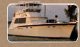
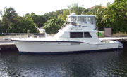
R/V Odyssey
|
The project will be conducted over a nine-day period from April 23 through May 1, 2006. The Florida Keys National Marine Sanctuary’s 52’ Hatteras, R/V Odyssey, will serve as both the dive platform and as the accommodations during the project. A total of eight days of diving are planned with four dives a day per diver. The remainder of the time will be used for travel, equipment set-up and break-down, as well as data post-processing.
Photo-Mosaic Technique
The Maritime Heritage Program’s photo-mosaic technique is continually evolving to create the most accurate product possible. It began by towing a diver with a video camera behind a diver propulsion vehicle (DPV) using depth gauges to remain at a constant depth. This method proved problematic because shipwrecks with differing levels of relief produced images with differing focal lengths, which made it impossible to accurately piece the images together. Also turbulence from the DPV’s propeller wash caused the video camera to shake. To alleviate these issues, two handheld digital SONAR systems were introduced to solve the focal length problems. The SONAR bounces sound waves off the bottom topography, i.e. the deck of a shipwreck, and the reflected sound waves are interpreted as a numeric readout in feet on the SONAR device. This insures that the camera remains at a consistent height over the shipwreck and produces an accurate scaled photo-mosaic of the site below.
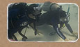
To solve the camera shake problems from the DPV propeller wash, the camera and SONAR have now been attached to a Farallon Mk8-Twin DPV sled. The Farallon Mk8-Twin system consists of two Mk8 DPVs attached to a central platform or sled. A riding saddle is attached to the platform as well as a saddle on each of the Mk8s. This unit is designed to transport one or two divers and a significant neutral payload. Because of its wide, rigid platform, or sled, the Mk8-Twin is an excellent camera platform for underwater filming.
A single diver can control the operation of the Mk8-Twin through the standard controls on each unit. At slow speeds, the Mk8-Twin can turn within its own radius. In case of any problems each Mk8 DPV can be removed easily and quickly from the central platform permitting each diver to operate the unit independently. The video camera in an underwater housing is attached by a downward facing ball mount to the front of the sled, which can easily be detached and adjusted by a diver. If necessary in low light conditions, two 50-watt HID underwater lights will be attached to the sled by adjustable arms to provide better illumination.
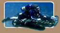
The photo-mosaic survey will be conducted by one diver who operates both the DPV sled and the video system. The diver will drive the DPV sled in equally spaced lanes while holding a consistent course-heading and height over the shipwreck. The height over the shipwreck will change daily due to variations in light, water turbidity, etc., and because of these factors a new height over the shipwreck will be determined at the beginning of each day’s survey. While driving the DPV sled, the diver will insure that the video camera is held steadily and positioned straight down at the wreck using a bubble level as a guide, all while keeping track of the area that has already been recorded underneath him. From past experience the best height off the shipwreck to create a photo-mosaic with the minimal amount of passes is between 25 and 30 feet off the deck. Generally at this height an approximate 15 foot swath of shipwreck is recorded by the video camera, which means that a shipwreck with a 45 foot beam will be documented in no more than three passes.
Once safely back on the surface, video editing software will be used to pull individual still frames from the video. The images will then be overlaid and pieced together using computer software. By overlaying the images one by one a photo-mosaic will be created of the entire shipwreck site.
PROJECT TIMELINE
April 22, 2006 - Travel to Key Largo, Florida
April 23, 2006 - Equipment set up and training dives
April 24, 2006 - Photo-mosaic survey of the City of Washington
April 25, 2006 - Photo-mosaic survey of the Benwood
April 26, 2006 - Photo-mosaic survey of the San Pedro
April 27, 2006 - Photo-mosaic survey of the Adelaide Baker Cluster A
April 28, 2006 - Photo-mosaic survey of the Adelaide Baker Cluster B
April 29, 2006 - Photo-mosaic survey of the North America
April 30, 2006 - Weather/trouble shooting day
May 1, 2006 - Weather/trouble shooting day
May 2, 2006 - Equipment break-down and mobilization
|