Mission Log: Sept. 18, 2006
by Noah Doughty, NOAA Teacher at Sea
Greetings from the sunny coast of California!
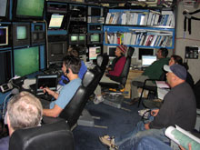 |
| The science crew watching video from the Tiburon in the control room of the Western Flyer . |
Today aboard ship we began to survey the wreck site of the USS Macon, a U.S. Navy Dirigible and it’s Sparrowhawk airplanes. The Macon sank off the coast near Big Sur, just south of Monterey, on February 12, 1935. The goal of the survey is to create a photomosaic image of the wreckage. To accomplish this we are using a remotely operated vehicle (ROV) called the Tiburon. Much of today’s operations centered on getting the ROV into the water early with the camera at a 45-degree angle to capture as many images of the wreck area as possible. Plus it enabled the scientists and historians on boat to get a feeling for the condition of the wreckage.Altogether we found all four of the airplanes, each in a different state of decomposition, but some parts remarkably well preserved (we could make out part of a star painted on one wing). One of the things the scientists did was to make a GIS map of the wreck site.
The real work begins tomorrow when researchers from Stanford University begin a two-day project to create the photomosaic of the area.
Click here to view a pdf of a GIS map of the MACON wreckage. Outlines indicate approximate location of various objects.
|