Mission Log: Sept. 21, 2006
by Noah Doughty, NOAA Teacher at Sea
Work at the USS Macon wreck site continues, alternating between mosaic work and survey work depending on water conditions at the bottom. Today's log will profile two members of the expedition whose jobs provide a context for the information being gathered.
| Mission Weather Report |
Visibility: Good
Wind direction and speed: NWxW 24kts
Swell direction and height: NW 6’-8’
Seawater temperature: 55.7°F
Sea level pressure: 1019 millibars
Cloud cover: 2/8 |
Erica Burton works for the Monterey Bay National Marine Sanctuary and is responsible for operating VARS, which stands for Video Annotation and Reference System. VARS is a database that allows screen images to be captured, logged, and geo-referenced with annotated notes. For the Macon expedition these notes list the possible identity of the artifacts. In addition to the captured image VARS also records the time stamp in the video and a geographical location.
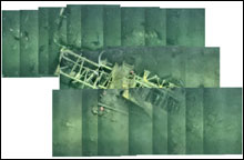 |
| This image, created with low-resolution copies of the image files, shows a Curtiss F9C-2 Sparrowhawk (plane #4 in the GIS map on the Day 1 log). High-resolution tiles will be fused into the final photo-mosaic. The nose of the plane is in the lower left. |
All the images and video captured are archived at MBARI (the Monterey Bay Aquarium Research Institute), and later, in conjunction with the National Marine Sanctuary Program, staff will process and interpret to produce a final photomosaic poster that will be made available to the public. Burton, who has a background in marine biology, also notes that the USS Macon wreckage provides an artificial hard-bottom habitat in an otherwise soft-bottom habitat, and the organisms observed are primarily soft-bottom fishes with occasional encrusting organisms on the wreckage.
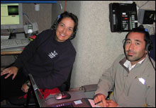 |
| Erica Burton, on the left, operates VARS (Video Annotation and Reference System), and works for the Monterey Bay National Marine Sanctuary. Lee Murai, on the right, is the expedition's GIS (Geographical Information System) analyst, and comes from Moss Landing Marine Laboratories. |
Lee Murai is a geological oceanography student at the Moss Landing Marine Laboratories and is the GIS (Geographical Information System) analyst. Through GIS software, he is able to spatially organize the data collected on this expedition and compare it to the 1990 and 1991 expeditions. Types of data collected in the past include side-scan sonar, multi-beam bathymetry, and waypoints collected by remotely operated vehicles (ROVs) and manned submersibles. For this expedition he is working closely with the Stanford University team to assist with the photomosaic collection procedure. The GIS map posted on the first day of the expedition was provided by Murai. Compare that to the low-resolution image tiles posted today. While the use of GIS is relatively new to the field of marine archeology, it is generally used in marine environments to provide geologic and biologic habitat characterization maps.
|