|
Mission Log: June 30, 2006
Putting Together a Jigsaw Puzzle -
Marine Archeology in Action
Paulo Maurin
University of Hawai`i
A few days ago we saw the maritime archeologists practice their technique of trilateration on the ship for cataloguing artifacts found on a shipwreck, and today we actually saw them in action. In the large lagoon of Kure Atoll, there are two sites that the team is working on: the USS Saginaw and an unknown whaler, most likely the Parker. The education team conducted a REEF fish count at a third site: the Hoei Maru, a Japanese whaling vessel that wrecked about 30 years ago.
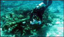 |
| Marine Archeologist Tane Casserley carefully swims over the anchor, with underwater paper in hand. (Photo: Paulo Maurin) |
The Hoei Maru ran aground on the outer edge of the reef, but it was during such a ferocious storm that the ship broke in half, and the bow was actually carried over the reef crest by the waves, and deposited on the inner part of the atoll, where it can be seen protruding out of the water. Wrecks often become prime real estate for fish, looking for shelter. Schooling fish tend to be attracted to the many hiding places a wreck provides – there were nehu (Hawaiian anchovy), yellowfin goatfish, and yellowstripe goatfish in abundance, the first one being over a hundred fish. The archeology team, however, is not studying this modern wreck. Their energy is devoted to the two older other wreck sites instead.
In an area where shipwrecks are numerous, how does a marine archeology team prioritize their work? There are four criteria that determine the importance of a wreck: 1) the historical value of the wreck, 2) its association with a famous person, 3) the uniqueness of the vessel, and 4) potential for archeological data. Based on these criteria, the team is studying two other wrecks: the USS Saginaw, and the Parker.
 |
| Lindsey Thomas, of the archeology team, ponders deeply how to best transcribe her dive sketches of the day onto the site map. (Photo: Paulo Maurin) |
The USS Saginaw is a ship that has a fascinating history, making it a priority wreck to study – it was used during the American involvement in the Pacific, protecting US citizens in Japan and China, and suppressing local pirates in the area. Later it was involved during the Civil War preventing Confederate activities, and finally sent to Midway to help support engineering activities meant to transform the atoll into a coaling station. It sank off Kure when it was passing by to look for any castaways in this northernmost atoll in the Hawaiian chain. Most of the wreck is located in the outer reef area, an area more exposed to the open seas and more difficult to work on. As a result, archeological work is constrained by good weather to conduct their research.
Identifying shipwrecks is like detective’s work. Some wrecks are more than a century old, and the information available tends to be fairly limited. It is only recently that more or less accurate records on ships and their wrecks have been kept. The identity of the second wreck at Kure Atoll is still a bit of a mystery, but records seem to indicate that it’s the Parker, a whaling vessel that wrecked on the reef in 1842. Many of the remnants of this vessel are located within the lagoon area of the atoll, where the ship has been resting since 1842. The site of the wreck is shallow, between 10 to 20 feet. Sheltered from the rough seas, in relatively warm waters and surrounded by an active coral reef, this wreck is considered to be among the most beautiful wreck sites in the world.
 |
| Brenda Altmeier's hands are busy at work, with the most trusted tools of archeologists: a pencil and a ruler, with the compass is nearby. (Photo: Paulo Maurin) |
We observed the archeological team at work on the Parker wreck today. Six divers were in the water, cataloging each of the artifacts they found. Each one has a small area of about 50 feet to cover and, using underwater paper and a pencil, they make sketches of artifacts found. After spending a full day in the field, marine archeologists have many individual sketches that are like small pieces of a giant Jigsaw puzzle – it only makes sense when they are put together with all of the other sketches. Then, and only then, you can see the big picture. Once this “big picture” is created, archeologists can make informed inferences about the nature of the wreck (how violent it was), and can asses both the impact of the environment on the wreck (how far are pieces being carried away), and also the impact of the wreck on the environment (coral reefs destroyed, animals that colonize it, etc).
To obtain this big picture, they gather all of their individual sketches (each one drawn in a regular sized paper) and transcribe them into a single site map using pencil, compasses, rulers, and art. They make all drawings fit in a page that measures several feet long, placed across a long table back at the ship. Solving this giant jigsaw puzzle takes many years – the archeology team estimates that, after many dives, it has only cataloged 60% of this wreck. But by patiently putting together one piece at a time, the puzzle will eventually be completed, and a mosaic of a shipwreck will emerge.
Wreck information obtained from Kure and Midway Atoll Maritime Heritage Survey, 2003, by Dr. Hans Van Tilburg.
|