|
Mission Log: July 4, 2006
A GIS Perspective
Ron Salz
U.S. Fish and Wildlife Service
This is the third or fourth day at sea on the NOAA ship Hi’ialakai, bathymetric survey mission HI0609. During the multiple day transit to Kure Atoll, our first destination, the days blur together, separated by meals, emergency drills, planning for our work, briefings from the other teams and, of course, watching sunsets.
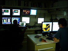 |
| Members of the mapping team work through the night in a small computer lab with numerous screens.(Photo: Claire Johnson/NOAA) |
My home office is in Honolulu, Hawai`i. On a normal work day I support a number of wildlife biologists with GIS, Geographic Information Systems. Work can include analyzing impacts of development on coral reefs in the Pacific, creating maps for recovery plans of endangered species, managing a collection of satellite imagery or developing training materials. It is interesting, fun and valuable work. But it all takes place at my desk.
A couple of years ago I met Joyce Miller from the Pacific Islands Benthic Habitat Mapping Center. We talked about the bathymetry mission in the Pacific Ocean and how she and Scott Ferguson envisioned the growth of the program. I went out on the research vessel Ahi for one day and had a great time (able to collect data, began to understand the process and didn’t get seasick). We talked about my participation with her teams sometime in the future.
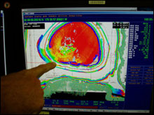 |
| Chief Scientist Dr. John Rooney points out the tracks that have been mapped around Kure Atoll.(Photo: Claire Johnson/NOAA) |
In April of 2006 I was invited to participate on a 6-day mapping cruise at Penguin Bank, between Moloka`i and O`ahu. The work was onboard the NOAA ship Hi’ialakai. That was my first time at sea and I enjoyed the experience and the work. As described elsewhere on this web site, we were collecting multibeam sonar data to create bathymetry or maps of the seafloor. I learned about the process of data collection and edited a lot of dots. Upon completion I asked that if another opportunity arose, to please see if I was available to participate. And in May I got a call from the Chief Scientist, Dr. John Rooney, to inquire about my availability for HI-06-09, a 28-day mission to the Northwestern Hawaiian Islands.
Twenty eight days? That is a long time to be away from home, from family, from the normal routine. So why do I want to participate in such a mission? And why would my office give me the time to do so? Here are my thoughts on the subject.
As a GIS/GPS specialist supporting offices throughout the Pacific Region, there are fewer and fewer opportunities to do first hand, primary source data collection. This is a result of the successful dispersal of GIS and GPS technologies, along with data and training, to field office personnel. If a Refuge Biologist can collect resource data with GPS, I don’t need to go to the field as often.
Working aboard the Hi’ialakai, however, is a unique opportunity for primary data collection in the field. The multibeam data and the resulting bathymetric maps have never existed before. By working with my colleagues from NOAA and the University of Hawai`i, I can participate and understand the data collection process and product output. This isn’t just an intellectual exercise, as I have used this same data in ship grounding incidents, as well as helping to develop marine survey areas for Service Biologists.
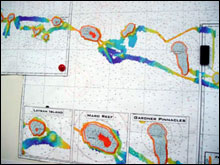 |
| A few ships have conducted high-resolution seafloor mapping in the Northwestern Hawaiian Islands as shown in the colorful track lines.(Photo: Claire Johnson/NOAA) |
Another reason to participate is the chance to visit some of the most remote locations in the Pacific Ocean. It is nearly 1400 miles from Honolulu to Kure Atoll. It is unusual for a GIS person to get to these locations. Space (and money) is needed to transport biologists and supplies. But as this mission requires a team effort, there are opportunities. The mapping team works in 3 rotating 10-hour shifts, so people are needed all hours of the day and nights. And that lets me visit these remote areas.
But what are the benefits of participating, in addition to primary data collection and visiting remote locations? I think of it in professional, technical and personal terms. Professionally, I get to work with great people from a number of organizations, including the University of Hawai`i and NOAA. Working together at sea enhances our professional working relationships back in Honolulu, where we have a common language to discuss the bathymetric products and their application.
Technically, I’m learning about different multi-beam sonar systems, sound velocity profiles, the process of collecting and editing field data, as well as the massive task of keeping metadata up to date, tracking all the files. And personally, this trip is an adventure. I’ll always be able to think of the rolling seas, the albatross flying wing-tip above the water, the dolphins playing in the ship’s wake, and the sunsets across the Pacific ocean. The technology will evolve, but those memories will remain for a lifetime.
|