|
Mission Log: July 16, 2006
2006 Maritime Heritage Survey in the
Northwestern Hawaiian Islands
Marine National Monument
Dr. Hans Van Tilburg
Team Lead
First things first: I have to applaud the maritime archaeology members of this year's survey for going far beyond where we've been before and accomplishing much more than could be expected for any single expedition. They have truly worked hard and merged their individual skills into a solid team. These divers rose before dawn to prepare dive gear and survey equipment, worked out of the small boats under difficult open ocean conditions, and then compiled data and drew site maps late into the night...each and every night, seven days a week. The team this year included: Brenda Altmeier (Florida Keys NMS), Dr. Kelly Gleason (Pacific Islands Region NMS), Tane Casserley (Maritime Heritage Program NMS), Lindsey Thomas (NOAA Hollings program intern from the University of Georgia), Robert Schwemmer (West Coast Region NMS), and myself. It has been a great field season for discoveries and research into our maritime heritage.
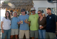 |
| The maritime archaeology team on the deck of the Hi'ialakai (l to r: L. Thomas, K. Gleason, T. Casserley, H. Van Tilburg, B. Altmeier, R. Schwemmer)(Photo: Emily Lundblad) |
Surveying wreck sites in the NWHI is difficult, but well worth the effort. The heritage resources in these remote atolls are unique examples of our common maritime past, sites unseen in any other part of the world. At Kure Atoll the wreck site of a 19th century whaling vessel captures the story of the New Bedford vessel Parker, lost during a violent storm in 1842 (preliminary identification). Anchors, chain, hull sheathing, copper fasteners, hawse pipes, windlass, rigging hardware, wire rope, bricks, and other material lie distributed in the shallow back reef area, the site where the vessel came to rest and broke apart. A trail of bricks and broken try pot pieces (cauldrons used to render the whale oil from the blubber) are scattered in a small pass through the reef crest. Outside the reef almost no artifacts were found at all. Apparently the violent seas brought the ship entirely into the lagoon, hundreds of meters from the reef pass, where she grounded. Certain deck features like the tryworks and pots were washed over the side as the ship entered the reef. This adds to the tale of the ship's castaways, who assembled rough rafts at the wreck site and drifted for eight days before reaching Green Island, where they were trapped for months awaiting rescue.
The site of the British whaler Pearl, lost at Pearl and Hermes Atoll in 1822, tells a different story. Discovered in 2004 by marine debris divers (part of NOAA's Pacific Islands Fisheries Science Center), the Pearl and her whaling consort Hermes grounded together but under calmer sea conditions, and their heavier ship components remain to seaward of the reef crest. Individual artifacts at this high energy site are quite deteriorated, but their distribution and superposition provide interpretation. Four of the Pearl's large iron try pots rest upon copper hull sheathing on the seafloor. The ship's deck equipment fell through the timbers where she lay. The largest of the anchors on the site (12-foot length) has a broken fluke, but this likely happened elsewhere on the voyage, for the anchor lies with the bow wreckage, un-deployed. Inshore another anchor was set, possibly to hold the stricken vessel in place after the grounding.
The wreck of the USS Saginaw at Kure Atoll illustrates Civil War-era naval maritime heritage, a transitional vessel of the Old Steam Navy. The small side wheel steamer ran into the reef on October 29th, 1870, while supporting channel improvements at Midway Atoll. Subsequent storms and seas on the exposed location literally pushed all of the steam vessel's heavy components into reef crevices. In extremely difficult conditions under the surf zone, the team discovered and photographed all of the major elements of the navy steamer, including bow and stern Parrott rifled pivot guns, 24-pdr broadside howitzers, steam oscillating inclined engine, port and starboard paddlewheel shafts, rim of paddlewheel, anchors, chain locker, steam machinery, boiler tubes, boiler face, rigging components, fasteners, rudder hardware, davits, sounding lead, and other remains. Distribution attests to the bow breaking off at the initial reef impact zone, and midships machinery falling just to the south, with the lighter components of the stern section being scattered into the back reef zone. Conditions on site prohibited in situ artifact measurements, baseline trilateration mapping, and even artifact positioning with handheld GPS units. This initial survey may prove to be the final chapter in the Saginaw's story, for the location is completely inaccessible under all but the most ideal (and most rare) conditions.
The team was fortunate enough to make a quick study of the extensive wreck site of the iron hulled sailing ship Dunnottar Castle, fortuitously discovered by Kure Atoll refuge staff while the researchers were in the vicinity. The 258-foot British ship was lost on July 15th, 1886, locking herself upright on the hard coralline substrate while bound for California from Australia hauling coal. Large sections of iron hull plate, iron frames, rigging, masts, auxiliary steam boiler, keelson, anchors, windlasses, winches, capstans, davits, rudder and steering gear, cargo hatches, bow sprit, hawse pipes, chain locker, ballast stone, deadeyes, chains, stringers, bitts, ladders etc. are firmly encrusted onto the sea bottom. Not even the largest swells can dislodge these heavy components. This is a complete assembly of a late 19th century commercial carrier, an incredible sight from the days of the tall ships like the Falls of Clyde, Balcalutha, and Star of India, when our maritime commerce was driven by steel masts and canvas, wind power and human hands (not fossil fuels).
Finally, the team is working on the identification of an unknown motor vessel at Pearl and Hermes Atoll, a maritime mystery. Also discovered in 2004 by marine debris divers from NOAA's Pacific Islands Fisheries Science Center, maritime archaeologists have now mapped three major artifact areas: 1) bow area with windlass, observation tower, ventilators and both hawse pipes and anchors (Japanese "Oshima" type dating to 1918); 2) cook stove area with remnants of battery boxes and insulators and electrical components and also marine head; and 3) engine skylight area, an intact deck skylight and main stack and ventilator component, along with scattered ventilator parts, pipes, and miscellaneous artifacts. Electrical components exhibit Chinese characters (translation pending), and insulators are marked with "H.K." (possibly "Hong Kong"). The vessel site has no engine components, but is in the vicinity of another site, an Atlas Imperial six-cylinder diesel engine block. Are the two possibly associated? The engine is contemporaneous with the anchor style. The preliminary findings suggest the possible scenario: an East Asian fishing vessel (tuna tower?) strikes the reef crest at Pearl and Hermes Atoll under power (propeller blades all bent). The bottom is torn out of the vessel, dropping the engine, and the wreck is pushed further into the lagoon where it sinks after striking two large coral heads in the vicinity of the site...sometime after 1918. The fate of the crew is unknown. What story is this? Are we looking at two wreck sites or one? Further research into the written documents is needed to solve the mystery.
We are fortunate to get to be able to record these resources, and now have the responsibly of sharing our maritime heritage research with the public via presentations, web site material, brochures, reports etc. This is not a job really but a driving passion to investigate our maritime past and foster appreciation for these seafaring stories captured amidst the diverse and fragile coral reef ecosystems. These wreck sites are the homes for many species of fish and invertebrates now, and like the natural resources that surround them, they deserve the protection and preservation awarded them by established laws and marine resource management. Sharing these stories is a way of "bringing the place to the people rather than bringing people to the place." This is integral to the maritime heritage goals of the Marine National Monument and NOAA's Sanctuary system.
We are also lucky to be a part of this multidisciplinary research effort. The mapping team members, under the direction of the Pacific Islands Fisheries Science Center, have shared their expertise with the archaeologists, particularly information regarding the prevalent spur-and-groove underwater topography which has had such an influence in shaping the wreck sites as we see them today. Likewise, the education team and the archaeologists have jointly benefited from the collaborative cruise. So for this field season, some site surveys have been completed, some initiated, and we're headed back to port with plenty of data to be refined and polished. The maritime heritage stories continue!
|