Hidden Habitat Highways
Over the past 5 years, researchers with the Flower Garden Banks National Marine Sanctuary have mapped more than 3700 sq. km of the northwestern Gulf of Mexico using High-Resolution Multibeam systems. This effort included areas both within and outside the sanctuary boundaries. The resulting charts provide the baseline upon which all future science is planned, and orchestrated.
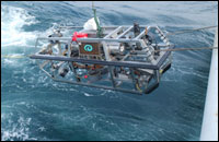 |
| The remotely operated vehicle (ROV) Argus which will provide live video feed throughout the expedition. (Photo: Institute for Exploration) |
Sanctuary researchers have since revisited many of these mapped areas to "ground truth", or determine exactly what the bottom surface looks like. Using a variety of manned and unmanned submersibles and remotely operated vehicles (ROVs) they have discovered that the bottom of the Gulf of Mexico isn't as plain and lifeless as once thought. Instead, it is dotted with a variety of outcroppings that harbor concentrations of life on the sea floor. In addition, geologic formations outlined clearly on the maps, show definitive geographic links, or highways, between these habitats.
Covering these outcroppings are varieties of black corals, octocorals, algae, fish and invertebrates. How did they get where they are? Why do the same species appear over and over again in our surveys? Scientists believe this is the result of the geographic connectivity within the region.
Over 160 marine organisms have been sampled during these surveys and sent to experts in different fields, for the purpose of identification. From this we are developing regional catalogs that will help researchers on the Secrets of the Gulf expedition identify what they are seeing, even if they are seeing it for the very first time.
The Secrets of the Gulf expedition also gives us a more extensive opportunity to explore these hidden highways by operating 24 hours a day for 6 days. We'll be able to cover more territory and collect more data to help us identify the similarities and differences along the sea floor of the outer continental shelf. By learning more about these areas surrounding the sanctuary, we can better understand the factors that may be influencing its development.
|