Mission Log: June 17, 2007
Paul Gayes
Director of Coastal's Center for Marine and Wetland Studies
 |
| Gayes |
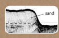
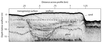
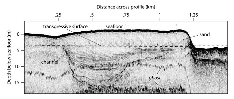
It is 2:30 am on the NOAA Ship Nancy Foster and the Coastal Carolina University team is conducting Chirp subbottom profile surveys. The Chirp system allows the shallow subsurface geologic framework to be imaged much like a depth sounder that also records reflections from surfaces below the sea floor. Having completed a survey grid to establish the shallow subsurface framework of the sanctuary itself, tonight we are imaging the region between Grays Reef and J Reef. Within this area several large paleochannels are present, some cutting down to 20 meters below the sea floor. These are old channels that extended across the northern border of the sanctuary when sea level was much lower than present. These channels were subsequently drowned by the rising sea and filled in with sediment. Several former large tidal inlets are also present as deep narrow incisions within these channel complexes. These inlets were similarly drowned and filled with sediment with the rising sea. Through the evening we will be tracing these channels towards the shore connecting them with the modern onshore drainage system. An example of one of the chirp profiles is provided below.
The Coastal group has completed extensive regional geologic framework studies on the inner shelf of South Carolina as part of the SC Sea Grant-US Geological Survey Coastal Erosion Study. These have supported regional sand resource, hardbottom reef habitat assessments and shelf evolution (www.coastal.edu/cmws and http://pubs.usgs.gov/of/2004/1013 and Baldwin, W.E. et al.,, 2005, Migration of the Pee Dee River System Inferred from Ancestral Paleochannels Underlying the South Carolina Grand Strand and Long Bay Inner Shelf, Geological Society of America Bulletin, vol. 118, no. 5-6, pp. 533-549.). Merging the present subsurface survey with previous multibeam bathymetric and side scan sonar mosaics provides a solid three-dimensional characterization of the geologic framework of the sanctuary.
Recently we have added electrical resistivity methods to the overall geophysical characterization to characterize the distribution of submarine groundwater discharge on the inner shelf of South Carolina. Working cooperatively with the Grays Reef staff and colleagues at Skidaway and University of Georgia we hope to build on past efforts by Jim Henry and others in the region and complete a similar integrated framework for the sanctuary area.
The Coastal Carolina team is composed of Paul Gayes (Director of Coastal’s Center for Marine and Wetland Studies), Jamie Phillips (lead CMWS Marine Operations Specialist), Jenna Hill (CMWS Post Doc), Jeff Marshall (CMWS Research Specialist) and Monica Price (a recent CCU Marine Science graduate). Later today, Clark Alexander and Mike Robinson from Skidaway Institute of Oceanography will join the geophysical group to continue to work.
|


