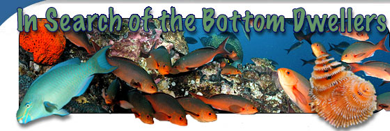
Monitoring of the Flower Garden Banks National Marine Sanctuary
The primary goal of this research mission is to supply the managers of the Flower Garden Banks National Marine Sanctuary (FGBNMS) with an improved understanding of the distribution and status of the animals they manage. The information collected will help to inform management decisions relating to environmental and human impacts. This mission will complement many other studies conducted at the FGBNMS since the 1970s by providing a more robust and quantitative characterization that will enable managers to better understand those impacts.
Why Monitor?
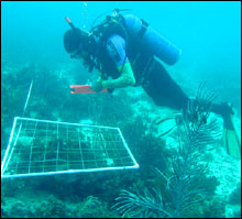 |
| A diver monitoring the site. (Photo: George Schmahl)
|
Monitoring allows managers to differentiate between types of impacts affecting their resources and to put in place regulations to help reduce or control these impacts. Impacts to the FGBNMS are both natural and human induced, with the latter easier to control through regulations. Natural impacts within the FGBNMS include pathogens, which virtually eliminated the Long-spined Sea Urchin population from the Atlantic basin (including the FGBNMS) in the early 1980’s, causing an increase in macroalgal cover and a decrease in corals. A second example is the increase in sea surface temperatures throughout tropical waters. This has resulted in a subsequent increase in coral bleaching accounts in the FGBNMS and has required additional monitoring to investigate the ability of local corals to recover.
Known human impacts include anchoring, which has resulted in significant damage to coral structure, as well as, fishing activity, and recreational diving. In addition to direct impacts, these activities have resulted in the deposition of remnant marine debris, such as anchors, abandoned fishing nets, and longlines. Until they degrade, this human made debris can be damaging to benthic habitats as well as the animals that live there for many years. Additionally, the seismic cable and defunct pipelines used in exploration and transportation of the oil and gas have been found to negatively affect neighboring habitats.
With an understanding of these natural and human pressures provided to Sanctuary management by existing monitoring efforts, they have successfully put into place a number of rules and regulations to protect the Sanctuary resources. Examples include: a ‘No Activity Zone” within the Sanctuary where oil exploration and production are prohibited; fishing that is permitted within the Sanctuary is restricted to conventional hook and line; mooring buoys were installed on both the East and West Banks in 1990 to prevent anchor damage; and in 2001 the International Maritime Organization designated the FGBNMS the “first international no-anchoring zone.”
Early Efforts to Monitor
Monitoring efforts at FGBNMS began in the 1970s. Early work focused primarily on monitoring more stationary animals with video transects and photostations documenting changes in coral, algae, and sponge communities over time. Until relatively recently, little was done to monitor the associated fish community. Initial efforts centered on providing species lists for the Banks and examining relationships between the species observed and depth. Researchers utilized a variety of techniques including SCUBA diving, hook and line, trawls, and submersibles to determine assemblage composition on the banks. In 1996 the Reef Environmental Education Foundation (REEF) began surveys of the Sanctuary and utilized a combination of REEF personnel, volunteers, and Sanctuary staff to visually census reef fish populations with diver surveys. These surveys have been invaluable in terms of species list development and understanding the ranges of these species.
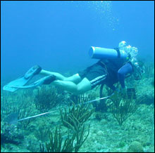 |
| A diver monitoring the site. (Photo: George Schmahl)
|
Quantitative monitoring of the fish communities began in the late 1980s; however, these surveys have all been focused on a relatively small portion of the East and West Bank’s coral cap environments. While excellent data has been collected, any statement made about the condition of resources on these Banks must be limited to these small regions making them difficult to utilize in developing an understanding of how resources are doing throughout the entire Sanctuary. This current mission complements these prior studies with the development of appropriate methods to cover the whole Sanctuary thus providing information on resource distribution throughout Sanctuary waters and a robust baseline for monitoring.
How do we monitor?
To obtain the necessary data, we will survey the fishes and corals at a number of locations around the Sanctuary. The maps that we are creating will allow us to ensure that we sample all the different habitats present so managers will have a thorough understanding of the fish and coral communities inhabiting each of them. This year we will be surveying the habitats shallower than 110 ft where we can use SCUBA. Next year we will use Remotely Operated Vehicles (ROVs) to survey the remainder of the Sanctuary located in waters too deep for diving.
At each survey location, two divers will descend to the reef. One diver will then identify, size, and count all fish species visible within a 25 X 4 meter long area. The second diver will record the coral species, amount of algae present, and note any marine debris. The relationships between the fish and their associated habitats will be examined and the data will be summarized to produce a baseline against which future monitoring missions can be compared to determine if conditions are better or worse.
Future uses
In addition to meeting current management needs, data from this mission will also provide managers with useful information to aid them in future decision making. Recently, during a series of public meetings, the Sanctuary was asked to consider expanding their current boundaries to include other offshore banks as well as to consider protecting some areas of the Sanctuary from all forms of human impacts. By comparing the data collected at the FGBNMS with data from other Banks, managers will be able to determine how unique or important those regions are. Also, if a protected area is created, future monitoring data can be compared with the data from this mission to determine how the fish and coral communities responded.
|