Error processing SSI file
|
Mission Blog: Sept. 23, 2009
Chelsea Lowes, Onboard Cruise Log Coordinator
Knauss Sea Grant Fellow, NOAA Ecosystem Research Program
Day 2 is the beginning of a more regular schedule of diving. After a full night of multibeam scanning of the eastern margin of the Tortugas Bank, we began the morning with a pre-dive meeting to discuss the particulars of each site (i.e. location, depth, etc.) as well as sharing any lessons learned from dives on previous days. Soon afterwards, the crew was ready to go and lifted the first small boat over the side. Divers climbed aboard and off they went! After the second small boat was lowered and sent off, the crew deployed the third boat in to check their repairs from yesterday. All seemed well, so tomorrow we'll be able to plan dives with three boats instead of two!
If you're curious about what the dive teams are up to, then let's walk through a site dive...
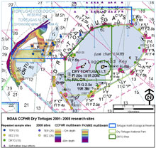 |
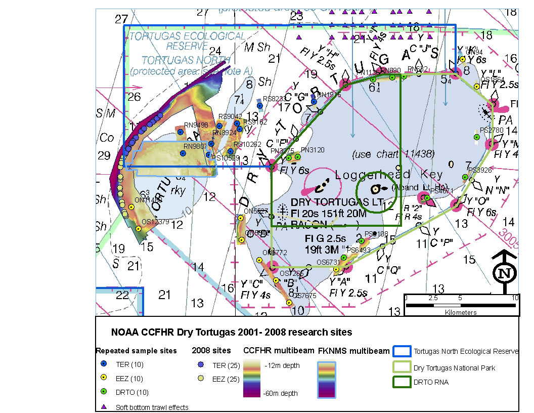
| CCHFR Study Sites. Click here for a larger image. (Photo: NOAA CCFHR) |
This study is aimed at examining the health of the ecosystem. One of the ways this is evaluated is by sampling at the reef interface - which is the point where the reef ends and transitions into a sandy bottom. At the beginning of the study in 2001, 30 sites were randomly selected from the reef interface. Ten sites are located within the Dry Tortugas National Park, which was initially established as a national monument in 1935 by President Franklin D. Roosevelt to protect Fort Jefferson and the surrounding areas. It was redesignated as a National Park in 1992. In the Park fishing is allowed, but is limited to only hook and line - so no big net hauls that you may picture commercial fishermen doing. Ten sites are located in the Tortugas Ecological Reserve area (no fishing or removal of marine organisms is allowed). Another ten sites are in the Exclusive Economic Zone (EEZ) - which is the area extending beyond the Reserve and Park out to 200 nautical miles from the shoreline of the islands. The EEZ is open to commercial and recreational fishing. This study design helps scientists compare ecosystem health between the different management zones. At the beginning of the study, fish abundance was similar among the three management zones. If the study documents fewer fish observed at the EEZ sites compared to the Reserve sites, this suggests that the Reserve designation is helping fish species rebound, restoring the balance of the system and promoting higher biodiversity.
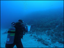 |
| Jenny Vander Pluym records data. (Photo: NOAA CCFHR) |
Using a global positioning system (GPS) a small boat carrying divers can pinpoint a site that has been surveyed in previous years. Once a site is located, a marker buoy is deployed to act as a visual aid for the divers as well as the person driving the boat (officially known as a coxswain) so they can stay near where the divers will come back to the surface. Once the divers descend to the bottom, they locate the reef interface and then set up a transect perpendicular to the interface. Using a soft measuring tape, the first diver - who is designated for fish identification and counting - swims a 30-meter line up onto reef while marking fish counts on a data sheet.
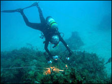 |
| Abigail Poray taking high resolution habitat photo. (Photo: NOAA CCFHR) |
Behind the fish counter, the second diver follows taking a picture every meter to be used later to analyze habitat.
Once both divers reach the end of the 30 meter transect, they turn around and roll up the tape back to the interface. Next, the fish counter swims another 30 meters in the opposite direction out into the sand, again doing fish identification and counts.
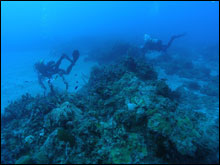 |
| John Burke and Abigail Poray at the transition from reef to sand bottom. (Photo: NOAA CCFHR) |
That diver then turns around again and rolls the soft measuring tape back up until arriving back at the reef interface, which completes the survey portion of the dive.
In order to head to the surface, the divers must first raise the anchor. This involves unrolling a float that has been attached to the anchor and using their exhaled bubbles to fill the float until it rises to the surface. The anchor is raised in this way so that it doesn't drag over the reef while the coxswain pulls it into the boat - instead it rises to the surface without doing any damage to critical habitat.
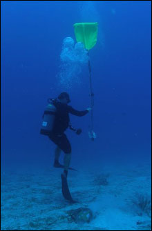 |
| Brian Degan using lift bag to raise anchor. (Photo: NOAA CCFHR) |
Once the buoy with the anchor rises to the surface, the coxswain waiting on the boat drives over and retrieves the marker buoy and anchor. Still on the bottom, each diver is carrying another float attached to a reel of line. In order to ascend, one diver unrolls their float and exhales bubbles into it - carefully letting it slowly rise to the surface while releasing line from the reel. Both divers then begin a slow ascent following that line. Once the divers ascend to a depth of 20 feet from the surface they perform a "safety stop" which is designed to allow any extra gas bubbles that have gotten into their blood to work their way out. This is a common practice for divers to avoid "getting the bends" - which is a very painful and potentially deadly side effect of ascending from deep depths too rapidly. After their safety stop, the divers continue their ascent and surface near their marker buoy. The coxswain, who has been waiting patiently from a distance, then drives up and helps the divers get themselves and their gear into the small boat. Another successful dive completed!
|


