| ||||||||||||||||
|
|
|
|
|
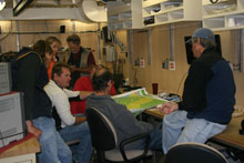
During the down time, waiting for the winds to relax, the science team has been following up with e-mails, other work and also sneaking in some time to browse the boat's expansive movie collection. Who knew there were so many zombie movies? The World Cup on satellite television has also been a source of inspiration. The exciting win from the USA soccer team during the last minutes of the game against Algeria has become the new analogy for the science mission of leg 2. The clock for completing our original sampling design of diving at randomly selected stations, stratified within habitat types at five locations is ticking away. The "upwelling winds" cost us four dive days.
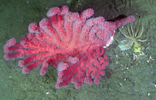
So to go for the goal of finding deep sea corals we are adapting our strategy to target the habitat most likely to contain deep-corals. Our sampling effort is now directed, rather than random. If winds subside, we'll focus on the deep (656-1,640 ft) rocky portion of the Cordell Bank continental slope. This is the region on the seafloor where the continental shelf (the gradually sloping submerged part of the continent that extends from the shore) breaks to the continental slope. The continental slope makes up 190 square miles of the Cordell Bank sanctuary (35% of the sanctuary seafloor) and extents from 656 feet down to 6,955 feet at the western boundary of the sanctuary. Very little is known about the slope region within the sanctuary.
Using bathymetry maps derived from multi-beam sonar data, Guy Cochrane, Geophysicist for the US Geological Survey, identified areas of the slope west of Cordell Bank where rocks are less likely to be covered with sediment. These areas are isolated from sediment transport on the shelf by canyons north and south of Cordell Bank that intercept shelf sediment and channel it into deeper basin water. Therefore, there is good potential that the slope region west of Cordell Bank, between the canyons, is steeply sloping bare rock, exposed to ocean currents - making a habitat suitable for deep sea corals. So as in any good game, with little time left on the clock we anxiously wait for a shot for the winning goal. In this case, once the weather breaks and we have the opportunity to dive the ROV on the Cordell Bank continental slope we hope to be jumping out of our seats yelling "Coooooooorals!!!" |
|
|||||||||||
|
||||||||||||||||