Today we dove the U-85 again. The wreck site is located just 14 miles from Oregon Inlet, so it was a quick trip out to the site. Once in the water, we discovered that the site had only about 10 feet of visibility, which made video and photo documentation difficult. However, even though the visibility was low, there was enough for the archaeologists to map the sunken German U-boat.
Two good dives of near 25-minutes each allowed a lot of work to be done on the site. As we come to the surface at the end of each dive, we make a safety stop about 15 feet below the surface, which allows are bodies to decompress some before we exit the water. The highlight of the day for me was encountering a school of dolphin fish when we were making our safety stop. They were awesome to see! I really love my job.
July 19
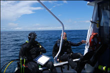
John McCord (UNC Coastal Studies Institutes) and Joe Hoyt ready to go overboard to dive U-701. (Photo: NOAA National Marine Sanctuaries)
With tropical storm Cristobal heading towards the Outer Banks, we headed out early and made the 40 mile run from Oregon Inlet to the U-701. There was a very strong current on the site today, making working and even staying on station on the site very difficult. Due to the intense current, it was exhausting maintaining our position while working. I was using the new lighting system, which actually made it even more difficult to stay on station. Its large size acted like a huge sail, helping to constantly push me away from the site. Often I would find that I was floating away from the site and would have to flatten myself horizontally so that I headed flat into the current. Then I would kick my fins quickly and once back on station, try to dig into the sand to keep myself in one place.
Despite the strong current, we had great visibility of 60 + feet or more. We were at about 110 feet and only had 20 minutes of bottom time, but we managed to get photo and video documentation, as well as some mapping completed. It was an awesome dive once again.
July 20
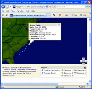
Today was a day off. Due to tropical storm Cristobal kicking up the wind and surf; we couldn’t go out to either site. But the team is pretty tired and needed the day of rest. We watched the weather channel and the forecast says that Cristobal should skirt off to the east and head out to open ocean by Tuesday. So it looks like we won’t be able to go out tomorrow either. However, this down time will give the team time to get other necessary work completed, such as rendering the video and working on the maps of the sites.
Tracking tropical storm Cristobal. (Photo: NOAA National Marine Sanctuaries)