Today we deployed sector scanning sonar to gain a different perspective of the wreck site and to aid in the mapping of the site. Originally, sector scanning sonar technology was developed primarily for the oil and gas industry to use on work class Remotely Operated Vehicles (ROV), which are very large in size, operated by a crew, and are used for jobs, such as deepwater trenching, cable burial, and recovering very large objects. However, in recent years, sector scanning sonar has found other uses on a smaller scale.
Essentially, sector scanning sonar technology is akin to an underwater radar system that is utilized to see far beyond the lights used on standard work class ROVs. The unit is mounted on a light-weight aluminum tripod, which is placed on the seafloor and tethered to the support vessel with a cable extending upwards through the water column. Utilizing a frequency of a 1000 kHz, the sonar is able to image out to well beyond a 300 foot radius and has been quite useful in the field of archaeology by providing detailed images of a shipwreck site.
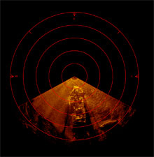
Sector scanning sonar image of the HMT Bedfordshire with the stern toward the center of the image. Click here for a larger image.
(Photo: NOAA)
The Minerals Management Service (MMS) recently purchased one of these tools in order to monitor and ensure that oil and gas companies comply with mitigations applied to their day-to-day operations. That is, MMS uses this tool as a way to make sure that the oil and gas operators are not damaging significant biological and/or historical resources. It is also useful as a means to examine the seafloor after oil and gas operators complete their proposed projects and clean up the material left on the seafloor.
This particular tool has been predominantly useful for recording images of shipwreck sites in the Gulf of Mexico. Specifically, MMS has used this tool to image sites, such as the Tristan de Luna fleet of 1559, as well as many other 19th and 20th century sites. For the purposes of the Battle of the Atlantic Expedition, MMS has brought the sector scanning sonar to image the remains of the ill-fated HMT Bedfordshire, which sank in May of 1942. It will be particularly useful to project personnel, as we construct the overall site map.
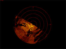
Sector scanning sonar image of the HMT Bedfordshire with the stern toward the center of the image. Click here for a larger image.
(Photo: NOAA)
The photos on this page are two images of HMT Bedfordshire at approximately a 120 foot radius from the location of the tripod. These two images were taken from both the bow and stern of the vessel. As described in Joe Hoyt's earlier blog, divers, using underwater communication, were directed to place the tripod at the bow and the stern of the wreck. These two images show the amount of hull remains left on the site, as well as the immense amount of destruction that the vessel incurred on that fateful night in 1942.
In particular, the two sonar images show the internal framework or the ribs of the vessel. Also, in the image from the bow section, one can see the remains of the compound boiler and its steam dome standing proud above the wreck. This is now a habitat to many trigger fish, as well as a host of other sea creatures. In fact, today as I was mapping in the area of the compound boiler, I was surprised by a large moray eel that decided to move out of the boiler area and find a new home along the starboard quarter of the vessel.
While to date the archaeological community has not extensively used the sector scanning sonar, we are hoping that its usefulness in this project, as well as in future projects, will facilitate a greater understanding of the condition of the sites, as they rest on the seafloor, and provide a best management strategy for our maritime heritage.