By Mauritius Valente Bell
AAUS Technical Diver, Georgia Aquarium
Today was our team's fifth day of survey on the HMT Bedfordshire, and I was greatly anticipating my dives on the site. Although a very experienced diver, I am new to archeological survey work. I have looked forward to this expedition, as it has provided me the first opportunity to utilize skills learned in the NOAA / Nautical Archaeology Society course I attended in May.
Over the past few days, I have been developing my survey/mapping pattern to make the most of the 25 minutes of bottom time that the wreck's 100-foot water depth allows. Although we could do longer bottom times, it would require decompression stops to allow nitrogen in the tissues of our body to be eliminated before surfacing; this would require much more logistical support to be conducted safely.
Assisting with the expedition are National Park Service partners Brett Seymour and Dave Conlin (Photo: NOAA)
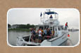
We rose this morning to clear skies and good sea conditions. This was my first day riding on East Carolina University's R/V Bee Liner, a small vessel that is generally operated in the Sound for oceanographic research. It was brought up from Greenville to replace the school's larger R/V Cutting Edge that had experienced mechanical issues the day before. I was forewarned that the vessel gives a notoriously poor ride offshore due to its design, but I figured it could not be any worse than I had already experienced - I was wrong. As we proceeded out of the sound and in to open ocean towards the wreck, I desperately searched for my cell phone to "Google" a local chiropractor, as a visit would surely be in order upon my return to shore! One thing could be agreed upon by all... the Bee Liner certainly does not lend itself to sleeping on the long rides out to the wreck site.
One and a half hours and a few misaligned vertebrae later, we arrived at the site. Our team donned our doubles cylinders, survey slates and tapes, and prepared to enter the water. Despite of the Bee Liner's shortcomings, it does have a nice wide gunwale (sidewall of the boat) allowing divers an easy back roll entry into the water. This feature is very desirable as it provides better support when sitting on the side wearing heavy double cylinders awaiting the go ahead to enter the water.
Eric, the vessel's captain, did a great job positioning the boat up current of the down line and buoy that we had placed earlier in the trip to mark the site. "Dive, Dive, Dive," was yelled by Eric and away we went. The current was over a knot, which when carrying double cylinders and survey gear, can prove to be quite a challenge. The goal is to drop ahead of the down line and at a rate rapid enough to descend to the bottom 100 feet below before the current blows you off of the site. Although not without a bit of exertion, our team did manage to safely descend together to the wreck below.
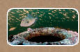
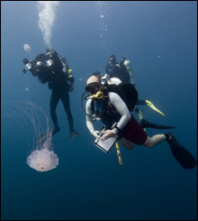
Divers, John McCord (UNC CSI) and Joe Hoyt (MNMS) ascend through the jellyfish. (Photo: Tane Casserley/NOAA)
The first dive was very frustrating for me... the enormous schools of jelly fish that we had become accustomed to during descents and ascents were now swimming with the current within a few feet of the bottom. Despite my staying as close to the bottom as possible, I still found myself ducking, dodging, and deflecting scores of these painful stinging creatures! This is a real nuisance, especially when you only have 25 minutes with which to work.
To add insult to injury, the ocean current and general contact by divers had greatly slackened the baseline tape that we take each measurement from. This completely threw off my previous survey. A more experienced surveyor would have simply adjusted their measurements, but I chose to erase and re-sketch my section on the second dive. After an hour or so on the surface, we splashed in for another 25 minutes of survey. I was on a mission to complete my entire section on this dive and I succeeded. We surfaced, boarded the Bee Liner, and headed back to shore.
The first 10 miles of our return trip were relatively uneventful and much smoother than the ride out due to our riding the back side of the waves, but then trouble began. About fifteen miles out, the port engine began to lose power followed by the starboard engine. The captain diagnosed the problem as debris in the fuel, which had occluded the fuel filter on each engine. As we limped to shore, both engines finally stalled about thirteen miles out. We were "dead in the water!"
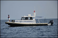
Todd Recicar (NOAA) standing at the bow of the R/V Sam Gray with Chad Meckley (NOAA) at the helm. (Photo: UNC CSI/NOAA)
A call to the Sam Gray, the NOAA vessel carrying the other half of the crew ahead of us, and to staff ashore and soon help was on the way. The staff on shore picked up some extra fuel filters from a local store and brought them out to us. However, despite filter replacement, the debris quickly clogged the new filters as well. Now the only option was to be towed in from 12 miles out by the Sam Gray. We had departed the dock at 0830 and eight long hours later, five hours after starting in from our last dive, we were finally back ashore. It was one long, hot day at sea!