Error processing SSI file
|
Interview with Tim VeenstraConducted by Stephanie Lachance, NOAA, NOS, Papahānaumokuākea Marine National Monument
1. What is your affiliation, and where are you from?
Airborne Technologies, Inc, - located in Wasilla, Alaska
2. How did you become interested in the Unmanned Aircraft System (UAS) project?
We have been involved with the GhostNet Project since it started in 2002. I was the project lead for the team, which consisted of our company, NOAA National Environmental Satellite Data Information Service (Bill Pichel – satellites), NOAA Earth Systems Research Laboratories (Jim Churnside – airborne remote sensing), I had worked with Jim on many other projects over the previous few years that had to do with aerial survey work, mostly in Alaskan waters), NOAA Pacific Islands Fisheries Science Center (Rusty Brainard, Kevin Wong et al.) Dave Foley (contractor to NOAA), the Alaskan Search And Rescue facility and others that have come and gone. Without going into detail here, the use of a ship launched UAS for ocean survey work, specifically ghostnets, was discussed in this group a number of years ago. My background is aviation, (pilot, mechanic, engineer) and we proposed that our company take the lead on evaluating available UAS's that might be adaptable for this type of work. Our research suggested that we could build our own that would specifically meet the needs for the project and for operations in the marine environment. So, the UAS interest started about 3 years ago and culminated in 2007 when we were awarded a contract to build and fly the aircraft we have on-board the Oscar Elton Sette.
3. Have you worked in the Pacific Region before?
Yes, quite a bit since 2002.
4. Have you worked on a ship at sea before, such as this one (Oscar Elton Sette)?
No. I do have extensive experience working with commercial fishing boats in the coastal environment. I flew an amphibious aircraft (still do) for many years in support of Alaskan fisheries. This involved a lot of aerial survey work and landing in the ocean to pull up to vessels of various sizes. I have never had any open ocean experience.
5. What are your areas of interest or your expertise?
Aviation, electronics, research and development (design, prototyping...)
6. What excites you about working with the UAS?
It is fun to get back into aviation again from a slightly different perspective. The Research and Development work has been a fun challenge. Working with a great team (Mike and Curt) has made it possible and totally worth it.
7. Any favorite or unique stories about the UAS in your previous experience?
Sorry, they are all sort of an adventure and the whole contract time frame and award amount has made this a very lean but challenging experience. Seeing it all come together in such short order like it has, makes it sort of unique. We had a lot of the pieces figured out but the whole airframe design happened quickly and has exceeded our expectations.
8. Why were you interested in coming on this expedition?
I had to! Plus, I would not have wanted to miss it.
9. What do you hope to accomplish during this research trip?
 |
From the GhostNet team’s perspective, I am hoping that the whole “convergence zone” thing with the Debris Estimated Likelihood Index (DELI) map, all comes together for the whole group. I have a strong interest in seeing what we have done with the GhostNet team, produce a useful product that can be used for future at-sea mitigation efforts of marine debris.
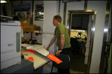
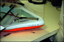
From the UAS perspective, we want to prove ship board operations; test our newest airframe (Malolo 2); reach the next stage of development with the numerous systems (video, autopilot system, communications, anomaly detection software....) and hopefully find some debris. The Federal Aviation Administration (FAA) restrictions at this time are going to make it difficult for the UAS to be an effective tool but we need to go through these learning steps anyway so I do not feel it is a waste of time or money. I feel that in a couple of years, the FAA might loosen their hold on airspace restrictions and operations, and by then, we should have a UAS that has been field tested and proven. The marine environment is harsh and unforgiving. We want to minimize losses or mishaps but expect them to be part of operations. So far, we have had no incidents, which is surprising in this type of R&D work. I don't expect to always have a perfect record but I hope this cruise will allow us to move forward with minimum collateral damage.
10. What do you think is the benefit of this work to conservation in the Pacific Region including the Monument?
I believe at-sea debris removal can be cost-effective and safer than removing debris from beaches and coral. The environmental damage will be lessened if we keep the nets from reaching the shores. This cruise will hopefully prove the usefulness of the DELI maps and be an encouragement to continued development of the UAS. With those two tools, annual mitigation efforts at sea will have a direct impact on the amount of debris accumulating in the Monument.
Personally, I would have liked to see one more proving flight with the NOAA P3 aircraft like we did in 2005. It is possible that we get really close to the convergence areas but miss them by miles. An aircraft would be able to cover so much more area and could react quickly and thus might help prove or improve the satellite data. Eventually, the UAS could do this job but it needs to be proven first, and we need to work more closely with FAA.
|