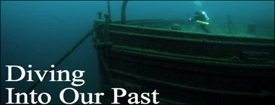
A NOAA diver investigates the bow of the wooden freighter SS Florida. The wreck lies in about 200 feet of water within Lake Huron. (Photo: Tane Caserley)
Technology Helps Maritime Heritage Managers Map the Past, Future
At Thunder Bay National Marine Sanctuary, lake bottom mapping data produced by NOAA's Office of the Coast Survey is being used in a couple different ways.
Russ Green, deputy superintendent, said having access to detailed bathymetric data has been helpful in identifying new resources and better characterizing the sanctuary, and could be useful in other planning initiatives involving state, regional and local entities. For example, the data will be made available to the Michigan Department of Natural Resources to help evaluate current fish spawning areas and determine the best place for a potential artificial reef.
In another initiative, the sanctuary is working with the University of Michigan to conduct a socioeconomic study of the proposed three-county sanctuary expansion area. The effort will measure the economic impact of NOAA's Great Lakes Maritime Heritage Center and help create a waterfront plan for the city of Alpena, Mich.
"We've used marine spatial planning to both enhance our ability to manage the resources under our stewardship, and also make forays into other conservation and planning areas," Green said. "All resource management and conservation efforts can benefit from marine spatial planning."
Tane Casserley, a marine archaeologist and national maritime heritage coordinator for the sanctuary system, said the spatial planning process is being used to put Thunder Bay's historic collection of shipwrecks in the larger context of the region's lighthouses, lifesaving stations, historic shipping routes and maritime economic activities.
"With marine spatial planning, you have NOAA offices working together combining satellite, bathymetric and historic data to create a clearer picture of the resources that we're managing," he said.
Elsewhere, NOAA's Special Projects Office is helping Monitor National Marine Sanctuary develop an innovative Google Earth computer map that vividly displays locations of shipwrecks, shipping lanes, military danger zones, fish habitat, historic lifeguard stations and boundary waters.
John Hayes, a mapping analyst working on the project, said the map will help managers identify potential conflicts and balance stakeholders' interests as the sanctuary explores possible expansion.
"This tool is built on the idea that a picture is worth a thousand words," Hayes said. "You can pull in all the relevant data and display it so that everybody can see what's out there. Spatially, you can see who's playing in these waters, so to speak, and where there may be competing interests that have to be addressed."
|