Site History and Resources
Overview
For more than 12,000 years, people have traveled on the Great Lakes. From Native American dugout canoes to wooden sailing craft and steel freighters, thousands of ships have made millions of voyages across the Inland Seas. The last 150 years have been particularly explosive, transforming the region into one of the world's busiest waterways. However, with extraordinary growth comes adversity. Fire, ice, collisions and storms have claimed nearly 200 vessels in and around Thunder Bay, including pioneer steamboats, majestic wooden schooners and huge steel freighters. Today, the 448-square-mile Thunder Bay National Marine Sanctuary protects one of America's best-preserved and nationally significant collections of shipwrecks. These historic sites capture dramatic moments from centuries that transformed America. As a collection, they illuminate an era of enormous national growth and remind us of risks taken and tragedies endured.
Currently, 45 shipwrecks are located in the sanctuary, with an additional 47 sites in an area currently being considered for sanctuary expansion (see Response section). The historical record suggests that as many as 100 shipwrecks are yet to be found in this northern region of Lake Huron. Although the sheer number of shipwrecks in and around the sanctuary is substantial, it is the wide range of vessel types and associated time span that imparts much of the collection's national significance. From an 1844 side-wheel steamer carrying passengers during America's westward expansion to a modern 500-foot German freighter laden with steel for the auto industry, the shipwrecks of Thunder Bay represent a microcosm of maritime commerce and travel on the Great Lakes.
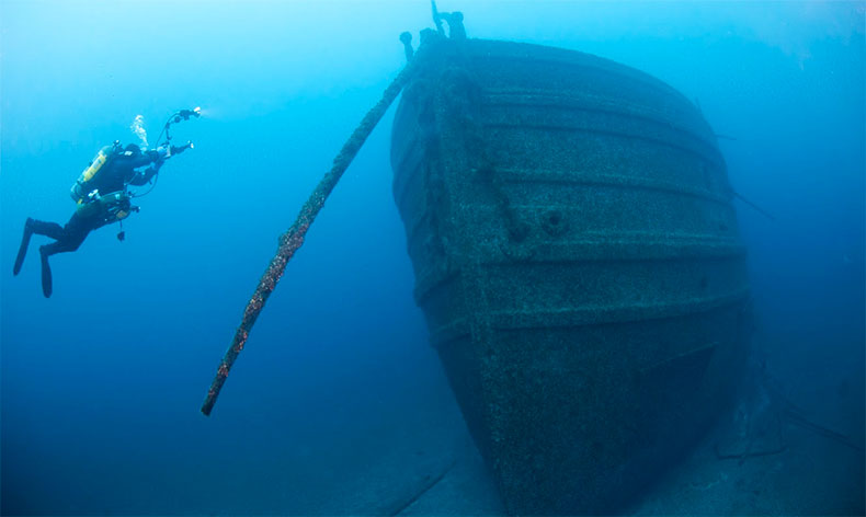
Remarkable preservation equally contributes to the collection's national significance. Lake Huron's cold, fresh water ensures that the Thunder Bay region's shipwrecks are among the best preserved in the world (Figures 1 and 2). Many sites have remained virtually unchanged for over 150 years. With masts still standing, deck hardware in place and many artifacts often surviving, sites located in deeper waters are true time capsules. Other shipwrecks lay broken up but well-preserved in shallower waters. Readily accessible by kayakers, snorkelers and divers of all abilities, these sites often provide sanctuary users with their first shipwreck experience. Believing that people will protect what they value, the sanctuary has made encouraging and facilitating public access to its historic shipwrecks a cornerstone of its resource protection efforts. Deep or shallow, intact or broken up, all of the sanctuary's shipwrecks possess historical, archaeological and recreational value.
The final contributing element to the sanctuary's national significance is its proven ability to creatively present the collection and its significance to the American people. As with providing physical access to sanctuary shipwrecks, the sanctuary's education and outreach efforts provide access to sanctuary resources for non-divers, while fostering an awareness and appreciation for the Great Lakes and their history. Thunder Bay National Marine Sanctuary protects our rich national maritime heritage through education, research and resource protection.

Location
The 448-square-mile Thunder Bay National Marine Sanctuary is located in northwestern Lake Huron (Figure 3). The sanctuary's northern and southern boundaries are defined by the lakeward extension of the respective Alpena County borders, while its eastern boundary is 83 degrees west longitude, approximately 20 miles from Alpena. The sanctuary's western boundary follows the contours of the Michigan shoreline at the ordinary high-water mark. Forty-five known shipwrecks are found in this area.
The sanctuary's 2000 designation documents called on the sanctuary to evaluate an expansion of its boundaries within five years of designation. In 2007, the Thunder Bay Sanctuary Advisory Council, as part of the sanctuary's management plan process, recommended that the sanctuary expand its boundaries to protect shipwrecks and other maritime archaeological resources in waters off the two counties adjacent to Alpena County (Alcona and Presque Isle counties). Based on this and other public input, the sanctuary's Final Management Plan (TBNMS 2009) includes a strategy calling on the sanctuary to evaluate this boundary alternative. Consequently, NOAA is currently engaged in an administrative process to expand the sanctuary's boundaries (see Response section), based on the Sanctuary Advisory Council's recommended study area. NOAA's preferred alternative is to increase the sanctuary boundary to 4,300 square miles. This would add 47 shipwrecks to the sanctuary. The new boundary would include all 92 historic shipwrecks in Alpena, Alcona and Presque Isle counties, and five shipwrecks from Mackinaw and Cheboygan counties (Figure 3).
Because of the many historically, archaeologically and recreationally significant shipwrecks outside the sanctuary's current boundaries, NOAA and the state of Michigan have increasingly included these sites in their research and resource protection efforts. The state of these resources, as well as the pressures on them and the sanctuary's response to these pressures, are included in this report.

The Michigan Historical Center represents the state of Michigan in managing the Thunder Bay National Marine Sanctuary. The center comprises the Michigan Historical Museum System and the Archives of Michigan. The center builds programs and alliances that preserve and interpret Michigan's past and help people discover, enjoy, and find inspiration in their heritage. The center is part of the Michigan Department of Natural Resources (DNR). The DNR is committed to the conservation, protection, management, use and enjoyment of the state's natural and cultural resources for current and future generations.
In 1981, the state of Michigan created the Thunder Bay Underwater Preserve, a 290-square-mile area designated as the first of 11 preserves authorized by Michigan's "Bottomlands Act.3" On Oct. 7, 2000, the Secretary of Commerce, under the National Marine Sanctuaries Act, expanded the boundaries to 448 square miles and designated Thunder Bay National Marine Sanctuary and Underwater Preserve4 as the nation's 13th national marine sanctuary. It is currently the only freshwater sanctuary, and the only sanctuary located in the Great Lakes.
The 448-square-mile area of northwestern Lake Huron is now both a national marine sanctuary and a state underwater preserve. The sanctuary is managed jointly by the National Oceanic and Atmospheric Administration (NOAA) and the state of Michigan. The sanctuary superintendent manages the day-to-day operations and activities of the site, while a Joint Management Committee, consisting of the director of the Office of National Marine Sanctuaries and the director of the Michigan Historical Center, makes major policy, budget and management decisions. In addition, an advisory council provides advice to the sanctuary superintendent. Members of the advisory council represent the community's interests, including government, education, maritime history and interpretation, fishing, diving, tourism, economic development, the state-designated underwater preserve, and the community at large.
Sanctuary Historical Context
From historical and archaeological perspectives, the resources of Thunder Bay National Marine Sanctuary represent a window into both America's past and the local and regional history of the area. The area's national significance - the basis for its designation as a national marine sanctuary - in many ways runs parallel with local history; the histories are connected, complementary and inform each other. This section briefly describes the sanctuary's broader historical context.
The Great Lakes and their connecting waterways provide a natural highway extending over a thousand miles into the heart of North America. For centuries before European contact, these inland seas and tributaries served as important lines of trade and communication for Native Americans. Over the past 300 years, these waters have been further exploited by Euro-Americans and have greatly contributed to the growth of the North American interior. Marine transport on the Great Lakes played a crucial role in the exploration, settlement and industrialization of the region.
During the 19th and early 20th centuries, the Great Lakes of North America evolved from an isolated maritime frontier on the western edge of the Atlantic World into the nation's busiest and the world's most significant industrial waterway, where innovative ships and technologies moved raw materials and agricultural products in larger quantities and at lower costs than at any previous time in history. During this period, entrepreneurs and shipbuilders on the Great Lakes launched tens of thousands of ships of many different designs. Sailing schooners, grand palace steamers, revolutionary propeller-driven passenger ships and industrial bulk carriers transported America's business and industry. In the process, they brought hundreds of thousands of people to the Midwest and made possible the dramatic growth of the region's farms, cities and industries. The Midwest, and indeed the American nation, could not have developed with such speed and with such vast economic and social consequences without the Great Lakes.
Dubbed "Shipwreck Alley," the treacherous waters around Thunder Bay have claimed nearly 200 ships. Intense weather patterns, islands and rocky shoals, heavy vessel traffic and converging shipping lanes all contributed to the area's vast collection of shipwrecks. These submerged archaeological sites are nearly a complete collection of Great Lakes vessel types, from small schooners and pioneer steamboats of the 1830s to enormous industrial bulk carriers that supported the Midwest's heavy industries during the 20th century. Among the wrecks in and around the sanctuary are those vessels that carried immigrants and pioneers traveling west for new homes, schooners carrying Midwestern grain and lumber, passengers and package freight steamers, and evolving generations of bulk freighters specially designed to carry iron ore, coal, grain, cement and other bulk commodities. They are evidence of the Great Lakes' pervasive influence in regional and national history, and they capture the cultural, personal, environmental, technological and economic aspects of maritime history. Finally, the shipwrecks identified in this report reflect the movement, bravery, tenacity and innovative spirit of generations of maritime people.
Maritime Archaeological Resources
The following narrative offers a representative account of maritime archaeological resources, chiefly historic shipwrecks, both in the current sanctuary boundaries and in the larger area being considered for sanctuary expansion. They are arranged here by vessel type and significance. After the name of each shipwreck, in parentheses, are the dates it was built and lost, as well as the depth of water that the site is located in. A complete list of known shipwrecks can be found in Appendix C.
Early Steam
The oldest known shipwreck in Thunder Bay is the wooden paddle wheel steamerNew Orleans (Figure 4). Rebuilt in 1843 on the hull of the burned steamerVermillion, New Orleans ran aground west of Sugar Island on June 15, 1849, and now rests in 13 feet of water. Fishermen from Thunder Bay Island and Sugar Island rescued the passengers and crew, and salvagers later recovered most of the cargo and machinery. Early steam paddle wheelers such as New Orleans are prime examples of the transition from sail to steam. Most were designed to carry large cargoes in their holds, while the upper works were elaborately decorated and furnished to accommodate ticketed passengers, many of them heading west to settle on the American frontier. In addition to New Orleans, two other paddle wheelers, Benjamin Franklin (1842-1850; 15-foot depth) and Albany (1846-1853; five-foot depth), grounded at Thunder Bay Island and Presque Isle, respectively. All three were extensively salvaged. The lower bilge, hull fragments, stern post and boiler area remnants of the New Orleans make for a complex and interesting shallow wreck site to visit. Little remains of the Albany and Franklin except the lower hull structure of each vessel, though Franklin's shafts, boilers and machinery remain on the lake bottom only a few hundred yards from the Thunder Bay Island lighthouse. The side-wheel steamer Marine City (1866-1880; five-foot depth) is similarly broken up in shallow water north of the Sturgeon Point Lighthouse (Figure 5). Carrying more than 150 people, the wooden vessel burned and sank in 1880 with the tragic loss of 20 lives.
Schooners

Notably, a group of schooners sunk on a pair of reefs in northern Lake Huron offers a dramatic connection between the maritime landscape and the shipwrecks associated with it. Spectacle Reef and nearby Raynold's Reef are a pair of shoals in Lake Huron about 10 miles northeast of Cheboygan. Over the years, scores of vessels have stranded on these shallow water reefs. In 1871, construction began on an 86-foot-tall lighthouse on Spectacle Reef, which was completed in 1874 and still stands today. In September 1869, just prior to construction of the lighthouse, theNightingale (1856-1869) stranded on the reef. Bound from Milwaukee to Oswego with 15,000 bushels of wheat, the schooner Kate Hayes (1856-1856) stranded on Spectacle Reef on a clear, calm night in 1856. Nearby are the schooners Newell Eddy (1890-1893) and Augustus Handy (1855-1861). The 242-foot, three-masted schooner barge Newell A. Eddy, built at West Bay City, Mich., in 1890, foundered in a storm with a cargo of grain and all nine hands in 1893. Resting in 160 feet of water, the well-preserved site is a popular dive attraction. In 1855, the Augustus Handy was struck by lightning, disabled and sunk.
Smaller schooners, usually involved in more local endeavors, are also found in the Thunder Bay area. Maid of the Mist (1863-1878; seven-foot depth), for example, was contracted to haul cedar posts from Alpena County to Detroit when it washed ashore in a gale at Huron Beach. Typical of the rough-and-tumble careers of Great Lakes schooners, the 15-year-old vessel was involved in a dozen mishaps before its ultimate demise, and evidence of large-scale repair is preserved in the archaeological record. The 117-foot William Stevens (1855-1863; 10-foot depth) and 112-foot Corsican (1862-1893; 160-foot depth) are further examples of these smaller-sized schooners, as is the 115-foot Defiance (Figure 7, 1848-1854; 185-foot depth), the second-earliest known shipwreck in the area. Remarkably well-preserved with tiller steering and cookstove and galley remnants on deck, Defianceis a rare example of an early Great Lakes schooner.


Schooners are not the only sailing craft located in the region. The three-masted bark Ogarita (1864-1905; 30-foot depth) and brig Bay City (1857-1902; 11-foot depth) both wrecked in the sanctuary. Ogarita burned and sank when its cargo of 1,200 tons of coal ignited off Thunder Bay Island, while the aging and battered Bay City was abandoned along the Alpena waterfront. The two-masted brigantine John J. Audubon (1854-1854; 170-foot depth) is located not far from its collision mate, the two-masted schooner Defiance mentioned above. Their 1854 collision illustrates the hazards of Great Lakes shipping as it emerged in the mid-19th century. The 1854 shipping season was the most costly to date, with losses totaling 119 lives, 70 ships and $2 million in property. Defiance and John J. Audubon were among the victims of that dangerous year.
Steamers

Similarly, the wooden steam barge B.W. Blanchard (Figures 9 and 10), 1870-1904; nine-foot depth) was towing the wooden schooner barges John T. Johnson (1873-1904; seven-foot depth) and John Kilderhouse when it went aground on North Point during a blinding snowstorm in November 1904. Blanchard and Johnsonwere completely wrecked, while Kilderhouse was eventually recovered. The vessels carried a combined load of 2,000,000 feet of lumber, most of which was recovered. The suspected Blanchard and Johnson sites today rest a few hundred feet apart in less than 10 feet of water. Though difficult to identify with precision, the scattered remains of several other vessels are located on North Point Reef as well, including the brig Empire State (1862-1877), schooner E. B. Palmer (1856-1892) and steamer Congress (1861-1868), which saw service during the Civil War in Tidewater, Va. Broken up into several large sections in deeper water off Thunder Bay Island is the steam barge William P. Thew (1884-1909; 70-foot depth), while closer inshore is the steam barge Oscar T. Flint (Figure 11, 1889-1909; 30-foot depth), which burned to the waterline and is still filled with its limestone cargo.

With examples spanning over 80 years, bulk and package freighters are also well represented in and around the sanctuary, including James Davidson (1874-1883; 38-foot depth), Joseph Fay (1871-1905; zero- to 17-foot depth), D. M. Wilson(1873-1894; 48-foot depth), Egyptian (1873-1897; 230-foot depth), New Orleans(1885-1906; 130-foot depth), William Rend (1888-1917; 17-foot depth), Shamrock(1875-1905; 11-foot depth), Monohansett (1872-1907; 18-foot depth), Florida(Figures 12 and 13), 1889-1897; 200-foot depth), Grecian (1891-1906; 90-foot depth), and Montana (Figures 14 and 15), 1872-l914; 60-foot depth). Many of these wrecks are popular dive destinations because of their structural integrity or unique circumstances of loss. Florida, for example, collided with the George W. Roby off Middle Island and went down with a cargo of 50,000 bushels of wheat, 1,451 barrels and 3,150 sacks of flour, syrup, barrels of whiskey, and a full upper load of package freight, much of which remains on site.


The steel-hulled bulk freight steamer Grecian, a Globe Iron Works creation, stranded at De Tour, Mich., then foundered in Thunder Bay while under tow southbound for repairs. Two large steel tanks known as canalons were sunk and fastened to Grecian's stern by hardhat divers intending to raise the vessel in 1909. The tanks exploded when filled with air and remain attached to the wreck. Grecian's sister ship, the 300-foot-long Norman (Figures 16 and 17), 1890-1895; 210-foot depth), is located just 20 miles north, having collided with the Canadian steamerJack in the busy shipping lanes off Presque Isle. Between 1890 and 1920, industrial giants like John D. Rockefeller created steel corporations that required vast Great Lakes fleets to carry iron ore, the main raw material used to make steel. TheGrecian and Norman were part of the fleet serving J. P. Morgan's enormous U.S. Steel Corporation, the nation's first billion-dollar firm.

Perhaps the most tragic accident in Thunder Bay occurred in August 1865, when the passenger freighter Pewabic (Figures 18-22), 1863-1865; 160-foot depth) was run into and sunk by its sister vessel Meteor with the loss of no fewer than 30 lives. Weather conditions were favorable and the vessels were in sight of one another for several miles before impact. Though injured, Meteor was able to continue to Sault Ste. Marie after rescuing many passengers from the water. Built by Peck and Masters of Cleveland, Pewabic went down with several hundred tons of valuable copper and iron ore in its hold. Search efforts began immediately, though the wreck was not discovered until June 1897. Much of the cargo was recovered using armored divers, submersible bells with manipulator arms, and bucket cranes, though at great cost; several divers perished on the wreck from drowning or decompression illnesses. At a time when Michigan's Upper Peninsula produced the majority of America's copper, vessels like Pewabic were critical to the war effort. The 200-foot steamer raced through the water at 12 knots, powered by twin engines that turned propellers eight feet in diameter.

Even with more accurate charts and advanced positioning, modern freighters still occasionally sank in Lake Huron during the 20th century. Isaac M. Scott (1909-1913; 175-foot depth) was one of eight vessels that sank in Lake Huron during an infamous storm in 1913. The storm took the lives of 194 seamen. The Scott, which sank with all hands onboard, lies upside down on the lake bottom like many of its contemporaries. D.R. Hanna (1906-1919; 130-foot depth), W.C. Franz (1901-1934; 230-foot depth), W. H. Gilbert (1892-1914; 230-foot depth), Viator (1904-1935; 165-foot depth), Etruria (1902-1905; 300-foot depth) and Monrovia (Figures 23 and 24, 1943-1959; 130-foot depth) all went down resulting from collisions in the busy shipping lanes off Thunder Bay. The German freighter Nordmeer (1954-1966; 35-foot depth), Thunder Bay's most recent shipwreck, ran upon a shoal and stuck fast in 1966. The steadfast crew remained onboard for several days hoping to free the freighter, necessitating a daring helicopter rescue by the U.S. Coast Guard amidst a November storm. A local landmark, the vessel's superstructure remained above the waterline for many years until finally succumbing to winter ice and storms and collapsing beneath the surface in 2010. A salvage barge, involved in recovery of scrap steel and machinery from Nordmeer, sits on the bottom near the larger wreck.


Maritime Cultural Landscapes

Also significant in number are the shore-side aspects of the region's maritime cultural landscape. As defined by the National Park Service, a cultural landscape is a geographic area including both cultural and natural resources, coastal environments, human communities, and related scenery that is associated with historic events, activities or persons, or exhibits other cultural or aesthetic values (NPS 1997). In addition to the submerged resources described above, maritime cultural landscapes are composed of many shoreline features such as beached shipwrecks, lighthouses, aids to navigation, abandoned docks, working waterfronts and Native American sites (Figures 26 through 28).

Water
Thunder Bay is located in Lake Huron, which is one of the Great Lakes and part of the world's largest freshwater ecosystem (Franks Taylor et al. 2010). Lake Huron is actually four separate but interacting bodies of water: the North Channel, Georgian Bay, Saginaw Bay and Lake Huron proper. The lake is 206 miles in length and a maximum of 183 miles wide (USEPA and Environment Canada 1988). The Lake Huron drainage basin is larger than any other Great Lake's, defined by an expansive watershed that totals 51,700 square miles and an estimated 3,826 miles of shoreline habitat (USEPA and Environment Canada 1988). It is the second-largest of the Great Lakes in area, with approximately 23,000 square miles of surface water, and the third-largest in volume, with 850 cubic miles of water.
The lake is heated significantly in spring, and then heat losses begin to occur over the summer through evaporation (Schertzer 2008). Peak surface temperatures in Thunder Bay are around 72 degrees and generally 68 degrees down to 50 feet. At 80 feet, about nine miles offshore, temperatures range from 40 to 60 degrees, depending on the thermocline, which can vary daily. Below the lowest thermocline, temperatures do not exceed 42 degrees through the year (J. Johnson, MI Dept. of Natural Resources, pers. comm., 2011).
Generally, in December, ice first forms in the bays and other protected areas of Lake Huron. In January, ice forms along the lake perimeter and more exposed shore, and by February, the mid-lake areas typically become frozen (Assel 2003, 2005). Lake Huron's cold, fresh water ensures that Thunder Bay's shipwrecks are among the best-preserved in the world (TBNMS 2009). However, ice and waves are natural processes that can impact exposed or shallow maritime archaeological resources in the sanctuary (see Pressures section).
The lake bottom within the sanctuary comprises unique features including several sinkholes in which water composition differs from other areas within the sanctuary. In 2003, water quality studies showed that relative to ambient lake water, water samples that were collected within sinkholes were characterized by slightly higher (4-7.5° C) temperatures, very high levels of chloride and conductivity (10-fold), as well as extremely high concentrations of organic matter, sulfate, and phosphorus. Observations at the submerged sinkholes also demonstrated the occurrence of unique biogeochemical conditions, providing a unique environment for a variety of specialized and uncommon bacteria types (Ruberg et al. 2005).
Habitat
Although some of the habitats have been fragmented and others have been nearly eliminated, in general the Lake Huron watershed basin exhibits a high level of diversity in its natural environments and has retained significant remnants of historic fish and wildlife habitat. This is largely a result of the Lake Huron watershed having a relatively low human population density. The area comprises coastal wetlands (swamps, marshes, bog and fens), islands and rocky shorelines, sand dunes, tributaries, savannahs and prairies. Historically, Lake Huron was connected to stream and inland lake tributaries that provided spawning habitats for many fish species. However, dam and hydroelectric facility construction in the 1800s excluded fish from many of these spawning sites. (EPA 2008)
Thunder Bay has a gradually sloping bottom with flats that extend from the nearshore area located off of the Thunder Bay River to the open waters of Lake Huron. Depths range from approximately 25 feet at the eastern boundaries of the nearshore areas to approximately 60 feet at the eastern boundary of Thunder Bay proper (NOAA 1999), although the sanctuary's actual boundaries run further offshore to a maximum depth of 330 feet near the northeast corner, less to the east and southeast. The sanctuary's lake bottom is composed of undifferentiated glacial till (unconsolidated rock materials of all sizes, including clay, silt, sand, gravel and boulders), rocky shoals, limestone walls and various reefs - bedrock exposures that often serve as important spawning habitats. The reef complexes in Thunder Bay are important spawning habitats for lake whitefish, walleye and lake trout and are typically heavily colonized by dreissenid mussels (NOAA 1999, EPA 2008, ONMS 2009).
As mentioned above, submerged sinkholes are present in the sanctuary and support a specialized local ecosystem (Figure 29). Thousands of years ago, Lake Huron's limestone bedrock was exposed to extremely low lake levels following the last glacial maximum. Karst sinkholes were created between 10,000 and 8,000 years ago when a chemical reaction between limestone and acidic water dissolved away passages or holes in the rock, leaving behind weakly supported ceilings that could easily collapse or sink. The Lake Huron sinkholes were subsequently covered with water and are currently seeping groundwater to the bottom of the lake, providing a unique habitat for aquatic life. Until recently, it was thought that such unique habitats caused by steep environmental gradients were only found only in oceans. Researchers are now considering the Lake Huron sinkholes to be analogous to marine vent ecosystems - freshwater biogeochemical "hot spots" where nutrients recycle rapidly and where novel organisms and community processes may be observed (Voorhies et al. 2012).5

Shipwrecks can also function as marine habitat. Marine studies have shown that although natural reefs tend to have greater overall species richness and abundance, artificial reefs, including shipwrecks, can function as habitat and attract a large diversity and abundance of ecologically and economically valuable species. Furthermore, it has been shown that artificial reefs in coastal habitats can enhance the production of reef-associated species (e.g., macroalgae, invertebrates and fishes) by serving as refuge and foraging grounds (Lindquist et al. 1989, Carr and Hixon 1997). Netting of reefs and observations of fish on shipwrecks by the Michigan Department of Natural Resources show that smallmouth bass and rock bass are the dominant species using both habitat types in warmer, nearshore waters during summer. Walleye use some of the reefs for spawning in spring. Deeper shipwrecks are less well-studied, but burbot often appear at these sites. Log perch, and especially round gobies, are common prey fishes occupying shallower reefs. The invasive Hemimysis has been found to occupy rocky nearshore habitats and perhaps shipwrecks more than other habitat types (MDNR and Central Michigan University, unpublished data).
Living Resources
A Changing Fish Community
The lake ecosystem has undergone significant changes over the last century, particularly in fish composition, due to changes in the lower food web. Historically, lake trout and burbot were the main fish predators in Lake Huron's deep waters and walleyes were the main nearshore predators. Lake herring, cisco species, sculpins and round whitefish comprised the historic prey fish base. In the 1990s, significant changes to the fish community resulted from overfishing, habitat loss and dam construction. The fish community was also greatly altered by the invasion of various fish species, the most significant of which being rainbow smelt in the 1920s, followed by alewife and the sea lamprey in the 1930s. Sea lamprey predation and overfishing led to the collapse of lake trout in the 1950s in most of Lake Huron. With no predators to control alewife and smelt populations, their numbers rapidly increased. The turnaround came with sea lamprey control in the 1960s, which allowed the survival of stocked Pacific salmon, lake trout and other predators. Restocking has controlled both smelt and alewife populations (EPA 2008). Other recent changes to the food web include the decline in pelagic species such as Chinook salmon, and the restoration of reproductively viable fish species in nearshore areas such as emerald shiner, walleye and yellow perch (Riley et. al., 2008; Fielder et. al., 2007; Johnson 2010). Today, the introduced Pacific salmon have been displaced to a large degree by recovering native predators, walleye and lake trout in particular. The prey base is still composed of a preponderance of nonnative species, led in abundance by rainbow smelt and round gobies (Riley et. al., 2008).
Lake Huron supports a diversity of aquatic plants and organisms, including many rare species, some of which are endemic to the Great Lakes, such as the ebony boghaunter, eastern pond mussel, mudpuppy, eastern fox snake, and piping plover. Recreationally important native fish such as lake trout, lake whitefish, walleye, smallmouth bass, northern pike, and yellow perch are also present. Aquatic animals that may be viewed near shipwrecks include benthic invertebrates such as sponges, hydras, aquatic worms, crayfish, freshwater shrimp, snails, clams, mussels and aquatic insects (Wetzel 1983, Pennak 1989, NOAA 1999).
Aquatic non-indigenous species are also present that can negatively impact ecosystem structure, shipwrecks and other maritime archaeological resources (EPA 2008, ONMS 2009). To date, a comprehensive field study of aquatic plants within the Thunder Bay region has not been completed.
Fish
In general, the fish inhabiting the Thunder Bay region can be characterized as forage and predator species. Important fish stocks in Lake Huron include lake whitefish (Coregonus clupeaformis), rainbow smelt (Osmerus mordax), bloaters (Coregonus hoyi), deepwater sculpin (Myoxocephalus thompsonii), slimy sculpin (Cottus cognatus), ninespine stickleback (Pungitius pungitius), lake herring (Coregonus artedii), suckers, and trout-perch (Percopsis omiscomaycus) (USFWS 1988, Argyle 1991, NOAA 1999). Most forage species can usually be found inshore near the lake bottom in search of food. Predatory fish species found in Lake Huron include lake trout (Salvelinus namaycush), brown trout (Salmo trutta), rainbow trout - the anadromous form, known as "steelhead" - (Oncorhynchus mykiss), coho salmon (O. kisutch), Chinook salmon (O. tshawytscha), pink salmon (O. gorbuscha), walleye (Sander vitreus), yellow perch(Perca flavescens) and burbot (Lota lota) (USFWS 1988, NOAA 1999). These species can be found in a wide range of depths within inshore and offshore areas of the lake, feeding upon forage fishes. Fish species observed around shipwrecks and other scuba diving sites in the Thunder Bay region include , brown trout, burbot, carp, channel catfish (Ictalurus punctatus), northern pike (Esox lucius), salmon, smallmouth bass (Micropterus dolomieu), steelhead, yellow perch and walleye (Warner and Holecek 1975, NOAA 1999).Reptiles and Amphibians
Species of reptiles and amphibians recorded for Alpena County that may inhabit the Thunder Bay region include the mudpuppy, Jefferson salamander (Ambystoma jeffersonianum), American toad (Bufo americanus), wood frog (Rana sylvatica), green frog, northern leopard frog (R. pipiens), eastern smooth green snake (Opheodrys vernalis), northern water snake (Nerodia sipedon), northern brown snake (Storeria dekayi), northern ribbon snake (Thamnophis sauritus), eastern garter snake (T. sirtalis), massasauga rattlesnake (Sistrurus catenatus), snapping turtle (Chelydra serpentina), and midland painted turtle (Chrysemys picta marginata) (Herdendorf et al. 1980, Harding and Holman 1990, NOAA 1999).Birds
Approximately 160 breeding bird species have been recorded for the Alpena region (Brewer et al. 1991, NOAA 1999) and include American coot (Fulica americana), barn swallow (Hirundo rustica), belted kingfisher (Megaceryle alcyon), Canada goose (Branta canadensis), great blue heron (Ardea herodias), green-backed heron (Butorides virescens), mallard (Anas platyrhynchos), tree swallow (Tachycineta bicolor), and wood duck (Aix sponsa). The most common colonial nesters on the islands of the bay are ring billed gulls (Larus delawarensis), double crested cormorants (Phalacrocorax auritus), and herring gulls (L. smithsonianus). Winter bird use of Lake Huron is generally low and may include mallard, common goldeneye (Bucephala clangula), common merganser (Mergus merganser), and red-breasted merganser (M. serrator) (USFWS 1988).Mammals
Mammals that may utilize the coastal wetlands of the Thunder Bay region include eastern cottontail (Sylvilagus floridanus), snowshoe hare (Lepus americanus), beaver (genus Castor), meadow vole (Microtus pennsylvanicus), muskrat (Ondatra zibethicus), red fox (Vulpes vulpes), raccoon (Procyon lotor), long-tailed weasel (Mustela frenata), mink (Neovison vison), river otter (Lontra canadensis), and white-tailed deer (Odocoileus virginianus) (Herdendorf et al. 1980, NOAA 1999).Non-indigenous species
As of 2006, at least 200 non-indigenous species have become established in the Great Lakes (Great Lakes Commission 2007). Some of the non-indigenous species in the Thunder Bay region include zebra and quagga mussels (Dreissena polymorpha and D. bugensis), spiny water flea (Bythotrephes longimanus), sea lamprey (Petromyzon marinus), round goby (Neogobius melanostomus), and white perch (Morone americana) (NOAA 1999) and the shrimp-like crustacean known as bloody-red shrimp (Hemimysis anomala). Information on the effects of non-indigenous species can be found in later sections of this report (see the Pressuressection and Question 11).. . . . . . . . . . . . . . .
3Bottomlands Act, 1980 PA 184, MCL 299.51 et seq. The state's preserve program is presently authorized by Part 761 of the Natural Resources and Environmental Protection Act, 1994 PA 451, MCL 324.76101 et seq.
4The official name of the sanctuary is the Thunder Bay National Marine Sanctuary and Underwater Preserve. To simplify the name, the Joint Management Committee has agreed to use the name Thunder Bay National Marine Sanctuary.
5For a more general overview see Doermann 2012.