National Marine Sanctuary System and System-Wide Monitoring
The National Marine Sanctuary System manages marine areas in both nearshore and open ocean waters that range in size from less than one to almost 140,000 square miles (362,598 square kilometers). Each area has its own concerns and requirements for environmental monitoring, but ecosystem structure and function in all these areas have similarities and are influenced by common factors that interact in comparable ways. Furthermore, the human influences that affect the structure and function of these sites are similar in a number of ways. For these reasons, in 2001 the program began to implement System-Wide Monitoring (SWiM). The monitoring framework (NMSP 2004) facilitates the development of effective, ecosystem-based monitoring programs that address management information needs using a design process that can be applied in a consistent way at multiple spatial scales and to multiple resource types. It identifies four primary components common among marine ecosystems: water, habitats, living resources and maritime archaeological resources.
By assuming that a common marine ecosystem framework can be applied to all places, the National Marine Sanctuary System developed a series of questions that are posed to every sanctuary and used as evaluation criteria to assess resource condition and trends. The questions, which are shown on the following page and explained in Appendix A, are derived from both a generalized ecosystem framework and from the National Marine Sanctuary System's mission. They are widely applicable across the system of areas managed by the sanctuary program and provide a tool with which the program can measure its progress toward maintaining and improving resource quality throughout the system.
Similar reports summarizing resource status and trends will be prepared for each marine sanctuary approximately every five years and updated as new information allows. The information in this report is intended to help set the stage for the management plan review process. The report also helps sanctuary staff identify monitoring, characterization and research priorities to address gaps, day-to-day information needs and new threats.
Thunder Bay National Marine Sanctuary
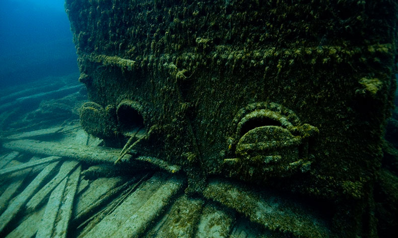
- Thunder Bay National Marine Sanctuary was designated on Oct. 7, 2000, to protect a nationally significant collection of shipwrecks and other maritime heritage resources.
- The sanctuary is located in northwestern Lake Huron off Alpena, Mich., and is jointly managed by NOAA and the state of Michigan.
- The 448-square-mile sanctuary protects one of America's best-preserved collections of shipwrecks.
- Historical research indicates that as many as 200 shipwrecks lie in and around Thunder Bay, representing a century and a half of maritime commerce and travel on the Great Lakes. To date, more than 45 shipwrecks have been discovered in the sanctuary, and an additional 62 have been located outside sanctuary boundaries in an area currently being considered for sanctuary expansion.
- It is the first sanctuary to focus solely on a large collection of maritime heritage resources.