Integrity of Heritage Resources
Greater Farallones
Why is it a concern?
While oral traditions speak of people from the dawn of time on the coast, little archaeological evidence is known about the Paleo- Indians of coastal Central California. By 11,000 years ago, the generally accepted date of earliest human habitation, sea level was already rising. But people may have come earlier, and evidence of that now lies in waters as deep as 300 feet. The Paleo- Coastal people may have either lived in the near-shore environment or lived inland and traveled to the shore to hunt marine mammals. In order to learn the nature of Paleo-Coastal habitation on the exposed late-Pleistocene/Holocene continental shelf, geophysical studies and prehistoric site modeling should be developed based on previously published regional archaeological assessments. Site prediction and sediment sampling would establish previous shorelines and relict landforms. Any cultural material would be of extreme significance.
Historically, the Farallon Islands and the mainland coast north of the Golden Gate have presented hazardous navigational obstacles to shipping. Today we are reminded of past shipwrecks in the place names. Such places as Franconia Bay, Noonday Rock, Tennessee Cove, Duxbury Reef and Pigeon Point are all named for shipwrecks. Year-round fog and dangerous winds and storms often led ships onto rocks and beaches to be pounded by the Pacific swells. Fierce currents have always swept in and out of the entrance to the Golden Gate. Ships were most vulnerable when trying to approach San Francisco or when trading along the coast seeking the shallow anchorages at Bodega, Tomales, Drake's Bay and Bolinas Bay. Until the 20th century, existing charts were incomplete and sometimes misleading. Lighthouses, buoys and other navigational aids were nonexistent until the 1850s.
Many known shipwrecks litter the ocean floor of the Greater Farallones sanctuary and they may also be found in Cordell Bank National Marine Sanctuary although no known historic wrecks have been discovered to date. The earliest recorded wreck in the sanctuary area was a Spanish Manila galleon, San Agustin, which sank in a gale while anchored in Drake's Bay in 1595. Several archaeological surveys have yet to provide conclusive evidence of the ship's remains. Another loss, the Ayacucho, was a brig that was engaged in the coastal trade that was described by Richard Henry Dana in his book, Two Years Before the Mast. Reportedly wrecked within Drake's Bay in 1841, she sank with a cargo of silks, brandy and other manufactured items. Remnants of fishing stations, wharves and makeshift landings may also exist within the sanctuary. While little probably remains of the coastal lumber shoots that were built on the rocks, wrecked lumber schooners and equipment may exist at lumber operation dog holes. However, more substantial metal-built vessels exist close to shore as battered wrecks, while more intact wrecks lie in deeper waters in the sanctuary.
Overview of Research
Research conducted by Sanctuary scientists and partners provides critical information to address existing and emerging resource conservation and management issues. The Overview of Research highlights some, but not necessarily all, of the research activities completed or ongoing at the Sanctuary.
| Project Name | PI and contacts | Links |
|---|---|---|
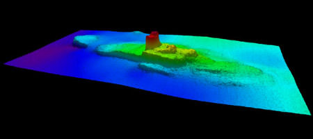
The Shipwreck Jacob Luckenbach |
http://sanctuaries.noaa.gov/maritime/expeditions/luckenbach.html |
|
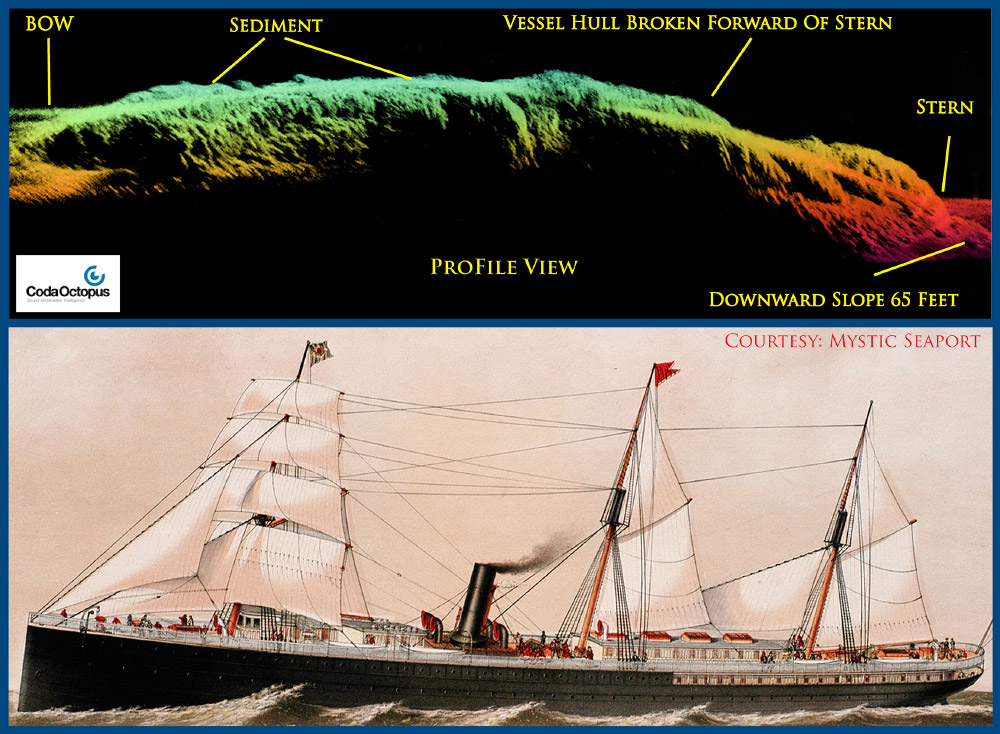
Revealing the Secrets of "San Francisco's Titanic" |
Science Needs and Questions
No "Science Needs" document has been prepared for the sanctuary but the following has been extrapolated from the Site Condition Report.
- What is the effect of bottom trawling on archaeological resource integrity?
- How can the dive community be informed on the treatment and conservation of submerged archaeological resources?
- What human activities may influence the quality of maritime archeological resources in the coastal environment, including the removal of artifacts from archeological sites, diving, anchoring and fishing activities (e.g., trawling, other gear impacts)?
Education and Outreach Material
Maritime Heritage in the West Coast Region
References
Maritime Heritage in the West Coast Region
Gulf of the Farallones National Marine Sanctuary Managemnt Plan: Cross-Cutting Action Plan