|

|
|||||
|
These activites have been created by Mike Guardino, Monterey Bay's Teacher in the Sea. We welcome educators to use these activities in their classrooms. Please submit any comments or improvements to Laura.Francis@noaa.gov Guiding Question How does a submersible's design address the limitations inherent to exploring the sea? Discussion The Sustainable Seas Expeditions will use a small submersible, Deepworker, to explore, conduct research in and promote conservation of the nation's 12 marine sanctuaries. This one-person vehicle must be simple enough to operate so pilots may complete their mission, yet sophisticated enough to safely reach depths of up to 600 meters (2,000 feet). By researching, constructing and testing a scale model prototype of a submersible, students will discover some of the design characteristics that make this vehicle so important to ocean exploration. Materials •A small aquarium (25 cm
deep Procedure 1. Tell students that their goal is to work with a classmate to design, build and test a submersible prototype that is neutrally buoyant and can travel through water. A small aquarium or other container, filled with clear, fresh water at ambient room temperature, will be available to test and demonstrate their submersibles. 2. Explain to students that their submersibles must meet certain specifications. Give them the Submersible Specifications and DeepWorker and Other Technologies handouts. 3. Set a date for students to demonstrate and explain their submersibles with each other, including what worked, what didn't work and how they redesigned their vehicle accordingly.
What is Neutral Buoyancy? Guiding Question What is neutral buoyancy and how does it affect a submersible's design? Discussion Density is a basic property of matter that measures the amount of mass of an object per unit volume (D=M/V). The density of freshwater is 1g/cm3; the density of seawater is greater and varies considerably depending upon salinity and temperature. (For seawater with a salinity of 34.5 parts per thousand and a temperature of 15C, the density is 1.025 g/cm3). In the ocean, solids are generally more dense than seawater. They tend to sink while gases are less dense and tend to rise. Water has an unusual property: its solid phase (ice) is less dense than most other solids, enabling it to float in liquid water. Buoyancy is the tendency of a fluid (gas or liquid) to exert an upward force on an object that is submerged in it. An object that is positively buoyant will float, one that is negatively buoyant will sink, while a substance that is neutrally buoyant displaces a quantity of matter of equal density. An object placed in seawater is more buoyant than the same object placed in freshwater. This is because the dissolved salts in seawater cause the water to be more dense. The volume of freshwater displaced by an object can be used to determine the mass required to make it neutrally buoyant. Important regularities concerning freshwater include: 1 mL H2O @ 4oC=1cm3=1 gram. Materials •Lead shot Procedure This activity may be used as a lab that students perform or as a demonstration. 1. Carefully measure freshwater into a 100 mL graduated cylinder so the bottom of the meniscus is precisely on the 80.0 mL line when viewed at eye level. 2. Mass a clean, dry 13 X 100 mL test tube and #00 rubber stopper on a milligram balance. 3. Add enough lead shot to the test tube (about half full) to make it negatively buoyant. Seal it with a tightly-fitting rubber stopper. Make a mark on the outside of the glass to record how far the stopper is inserted into the test tube. 4. Gently slide the test tube, stopper end down, into the graduated cylinder by tilting the glassware to one side. 5. Read the new volume in the graduated cylinder and determine the amount of water that has been displaced by the sealed test tube. Be sure no air bubbles have been trapped before taking this measurement. (Ask students why this is important: the trapped air displaces water, giving an inaccurate measurement.) Subtract the initial water volume (80.0 mL) from the (greater) final volume and convert to mass in grams. 6. Pour out the water and remove the weighted test tube from the graduated cylinder. Empty the test tube and replace the rubber stopper to the same mark on the glass. Refill the graduated cylinder to the 80.0 mL line and drop the empty tube in with the stopper end down. What volume does this positively buoyant object displace? 7. Remove the test tube again and add just enough lead shot to equal the mass of the displaced water. Refill the graduated cylinder with water to the 80.0 mL line and slide the neutrally buoyant test tube back in. Does the tube now rest in the water column rather than sink or float? Make any adjustments necessary to achieve neutral buoyancy. Data and Calculations: Mass of test tube and stopper = _____g Final volume (_____mL) - initial volume (80.0 mL) = H2O volume displaced (_____mL) Mass of displaced water (1 mL = 1g) = _____g Conclusion Compare to what would happen if the same activity was done using seawater. How would the shot weight need to be adjusted in seawater? Guide the discussion to consider how neutral buoyancy relates to submersibles, how students might address this in their designs and how this feature benefits research.
Purifying the Air for DeepWorker Pilots Guiding Question How is the air in DeepWorker continually purified for pilots? Discussion The DeepWorker 2000 submersible uses "rebreather" technology to chemically remove carbon dioxide from a pilots' expired breath and a pair of high pressure cylinders to replenish the oxygen gas metabolized by aerobic respiration. This lab allows students to calculate the volume of carbon dioxide gas that can be removed from DeepWorker's cabin by the absorbent chemical "Soda-Lime." Soda-Lime, which is a mixture of caustic soda and lime [NaOH and Ca(OH)2], is a chemical scrubber used to remove carbon dioxide from the air that has been expired by the pilot. SodaSorb ® (the brand of soda-lime used by DeepWorker) is manufactured by the W.R. Grace Company in the United States. SodaSorb ® consists of 70-80 percent Ca(OH)2, 16-20 percent H2O, 1-2 percent NaOH and 0-1 percent KOH. The mechanism for this exothermic reaction is: H2O(l) = CO2(g) ------- Na2CO3(s) = 2H2O(l) 2NaOH(s) = H2CO3(aq) ------- Na2CO3(s) = 2H2O(l) Ca(OH)2(s) = H2CO3(aq) ------- CaCO3(s) = 2H2O(l) There is a net production of three H2O molecules for every molecule of CO2 absorbed. Some chemical absorbents employ an indicator that changes color when the reactant is exhausted. The ethyl violet indicator in SodaSorb ® changes from white to purple when the chemical can absorb no additional CO2. When a person breathes, 0.82L of CO2 is exhaled for every liter of O2 inhaled. An O2 generation system should either produce a larger volume of O2 than the volume of CO2 consumed or make-up for the difference with a supplemental O2 supply. A gas "regulator" is used to deliver gas to the DeepWorker's cabin at the proper rate. Pressure gauges monitor the supply of O2(g) in DeepWorker's twin cylinders. The temperature of the absorbent influences the effectiveness of the reaction. SodaSorb ® works much better in the relatively warm cabin of DeepWorker. Materials •Safety equipment
(rubber gloves and eye protection) Procedure This activity may be used as a lab that students perform or as a demonstration. 1. Mass out 1.000 grams of SodaSorb ® on a milligram balance and place it in a gas collecting device. Be careful to avoid packing the solid too tightly and be certain not to breathe the dust. "Scrubbed" air exits through small holes in cap 1.000 grams SodaSorb ® Exhale into large hole at end)) 2. Determine the tidal volume of gas that you produce in one minute by exhaling into a spirometer. An adequate homemade spirometer can be constructed with an overturned bottle of water, a dish pan and a length of rubber hose. 3. Begin exhaling at a normal rate into the gas collecting device and use a timer to determine how long you can continue before the ethyl violet indicator in the SodaSorb ® turns purple. Assume that the chemical is exhausted at the first sign of a color change. 4. Determine the volume of gas that you exhaled by multiplying the time in minutes by the volume produced per minute. 5. Given that the average person at rest has 3.6 percent CO2 (g) by volume in their expired breath, calculate the volume of CO2 (g) that was absorbed by the SodaSorb ®. Data and Calculations Volume of expired breath per minute: _______ liters Time elapsed before indicator changes: _________ minutes Volume of CO2 absorbed per gram of SodaSorb ®: ____________
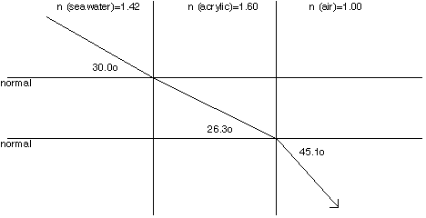
Sustainable Seas Expeditions "In the Zone" Laboratory Activity Guiding Questions How are No-Take Zones monitored within our national marine sanctuaries? How is undersea research conducted? What role does technology have in the preservation of the marine environment? How can a concerned citizen take action that will make a positive impact upon the future of America's National Marine Sanctuaries? Discussion A number of "marine ecological reserves" have been designated along the California coast, including the Big Creek Ecological Reserve (BCER) located in the Monterey Bay National Marine Sanctuary. In January 1994, this 8 km2 area was designated a "No-Take Zone", where commercial and recreational harvesting of natural resources is not permitted. No-Take Zones serve as excellent locations to study the effectiveness of a "sanctuary within a sanctuary". By affording a higher degree of protection to these marine ecological reserves within our national marine sanctuaries, we can better understand the dynamics of natural systems that are free from consumptive exploitation. "Zones" can be used as natural laboratories to further the research, conservation, exploration, and educational goals of the national marine sanctuary in which they lie. For example, the base-line data collected in a No-Take Zone can be used to help monitor the health of the national marine sanctuary with which it is associated, and be the basis for informed management decisions. In addition, the abundant, mature, reproductive stock in a No-Take Zone can help nearby populations of organisms recover from the pressures of overfishing by the recruitment of juveniles to denuded areas. A clearer picture of how to manage fisheries and establish (accurate) maximum sustainable yields of marine resources can also result. Therefore, an entire national marine sanctuary surrounding a No-Take Zone can benefit from the protected areas within it. Some No-Take Zones are chosen because they already feature an undisturbed environment that is worth preserving, while others may be selected to prevent further damage to, and allow for the recovery of, a unique marine community. Such was the case when 750 submerged acres were added to the Pt. Lobos Reserve in 1960. After recovering from many years of heavy fishing pressure, including the commercial harvest of abalone, the reserve now features the species abundance and diversity that is characteristic of a pristine kelp forest community. It may take time to realize the benefits of No-Take Zones within our national marine sanctuaries, but it will certainly be worth the wait as we witness their establishment and recovery. Much like our national park system that encourages multiple non-consumptive uses, No-Take Zones can also be enjoyed by photographers, boaters, surfers, swimmers, divers, and those who appreciate the value of protecting a natural system. The Sustainable Seas Expeditions will assist in conducting research projects at Pt. Lobos and BCER. The DeepWorker 2000 submersible will be deployed from the NOAA Ship McArthur where Dr. Mary Yoklavich of the National Marine Fisheries Service will have the opportunity to verify the benthic features that were remotely identified in previous investigations. She will also be able to monitor the variety of benthic rockfish species and their habitat preferences as she completes a strip transect and records her observations on video. Materials •(2) laser pointers Procedure 1 How can No-Take Zones such as Big Creek Ecological Reserve (BCER) and Pt. Lobos be accurately located on existing nautical charts? How can technology be used to produce reliable maps of these protected areas? 1. In order to establish, monitor, and effectively manage a marine reserve, a variety of data must be collected to accurately characterize the physical and biological features of the No-Take Zone. A fundamental challenge lies in producing a precise map of the benthic habitat with sufficient enough detail to determine the correlation between various species of invertebrates and fishes and their preferred habitat. Locate the Big Creek Reserve on the Monterey Bay National Marine Sanctuary Bathymetric Map (scale 1:30,000). BCER is a small (8 km2) No-Take Zone located approximately 90 km south of Monterey between Partington Point and Lopez Point. BCER ranges from 36o05'50" (north latitude) at its northern border to 36o03'38" at its southern edge and it extends ~3 km offshore to the 50 fathom contour (91 meters). This represents 4.5 km of coastline between Rate Creek and a point ~ 1 km south of the Big Creek Bridge. The northern and southern boundaries are marked by 2 meter diameter, orange-red triangles 30 meters above the ocean. What are the bathymetric contour intervals on the map? Why do you think the contour intervals change at 150 meters? What is the depth range within the BCER? How would you interpret the bottom topography of BCER based upon the number and spacing of contour lines? Procedure 2 The Monterey Bay Aquarium Research Institute (MBARI) produced a Geographic Information System (GIS) Data CD-ROM of Monterey Bay in September, 1998 that is readily available (http://www.mbari.org). The program can be used to produce maps of coastlines, bathymetry, and geologic features within Monterey and Carmel Bays. Use the GIS to generate maps of Carmel Canyon in and around Pt. Lobos Reserve. What problems exist with making observations from inside of the acrylic dome of the DeepWorker submersible and how can the length of a transect and the size of organisms be accurately measured? 1. Due to the double refraction of light that passes from sea water, through the DeepWorker's acrylic dome, and into the air of the cabin, it is extremely difficult for a pilot/scientist to accurately judge size and distance. The pilot must use an alternative method of making precise quantitative measurements while conducting strip transects. 2. To illustrate the problem of visual distortion experienced by a pilot, the following calculations illustrate why the observer must not trust the "fish bowl" view of her study site. 3. The speed of light (c=3.00 X 10⁸m/s in a vacuum) is much slower when it passes through other transparent media. Typical values for light passing through seawater, acrylic, and air are .704 c, .625 c, and 1.00 c respectively. Due to the velocity change when light passes from one medium into another, it bends at their interface. Approximate indices of refraction for this bending include: n (seawater)=1.42, n (acrylic)=1.60, n (air)= 1.00. Snell's Law (n1 sin i = n2 sin r, where i is the incident angle and r is the refracted angle) can be used to determine the changing path of light (an image) from its source to the eye of the pilot. Example: Calculate the path of light coming from seawater and passing through an acrylic window at a 30.0o angle before being received by a pilot inside the DeepWorker (Figure #1). If 1.42 sin 30.0o = 1.60 sin r, then 1.42/1.60 sin 30.0o=sin r=.444=26.3o If 1.60 sin 26.3o = 1.00 sin r, then 1.60/1.00 sin 26.3o=sin r=.709=45.1o
Figure #1: Refraction of light being received by DeepWorker pilot.
4. Compounding the problem of distortion is the curvature of the acrylic dome though which a pilot views her study site. Procedure 3 How can the velocity of a submersible and the length of a transect it follows be accurately measured? How can the size of organisms and geologic features they are associated with be accurately measured? 1. Mount a pair of laser pointers on a video camera at a measured distance apart. Arrange the lasers so that the beams are exactly parallel to each other and separated by at least .2500 meters. Slowly walk along a straight line course at a constant velocity while filming the ground and the pair of red spots produced by the lasers. Try to maintain a constant camera angle while filming your simulated transect for 1.00 minutes. 2. Watch the video you have produced and use a stop watch to determine how long it takes for the image of both laser spots to travel past one position on the ground and repeat this procedure several times in order to increase the sample size. Calculate the mean velocity maintained during your simulated transect in m/s (velocity = distance ÷ time). 3. Calculate the length of your transect by solving the uniform velocity equation for distance (distance = velocity X time). 4. Estimate the size of "organisms" and "benthic features" by comparing their video images to the known distance between laser spots in the image Procedure 4 What do we now know about BCER and what do we still need to study? A brief summary of the biological, geological, and oceanographic data that has been collected in and around BCER is provided below. It is your job to analyze the data and make recommendations concerning the value of designating No-Take Zones within our national Marine Sanctuaries. You can also suggest additional investigations and/or data that should be collected in order to produce an accurate characterization of the BCER. While reading through the information, consider whether establishing BCER is an effective way of protecting, monitoring, managing, and enhancing a fishery within the Monterey Bay National Marine Sanctuary. There are ~57 species of rockfish (Sebastes sp.) along the California coast and several of them have experienced considerable fishing pressure. Many species of benthic rockfishes are sedentary in their behavior and are extremely long lived. Just what is a "rockfish" and what is the value of their commercial and recreational fisheries? The BCER is located in a geologically diverse area near the Pacific and North American Plate boundaries. The area features a narrow continental shelf with exposed bedrock. Roughly eight percent of the area inside and adjacent to the reserve is composed of rocky substrate with high relief that serves as habitat for a variety of benthic rockfish species (Sebastes sp.). Researches have identified eight types of benthic fish habitat in their efforts to render an accurate characterization of 24.6 km2 of BCER and adjacent areas in 30-200 meters of seawater. •fine sediment (particle
diameter <.06 mm) Why is it important to consider the geologic history and types of substrate associated with BCER? In order to assess the distribution of larval fishes from BCER and their recruitment to adjacent fisheries, the currents that flow along the coast were carefully monitored from the surface to depths of 200 meters. Persistent winds (blowing toward the equator) in the spring and summer along the California coast cause the Ekman spiral, the transport of a warm surface layer offshore, and its replacement with cooler water that upwells from below. The onset of upwelling season in the Spring is variable and the cool temperatures and general southward current flow associated with it can be interrupted with periodic changes in wind speed and direction. Strong upwelling can be detected by SST imagery as cold coastal water. When wind strength weakens there is a relaxation in upwelling and the warm waters of the California Current move closer to shore. Currents along the Big Sur coast exhibit a persistent northward flow that has been documented at various times in the past. This north flowing current can be quite strong and it extends from the surface to the depths of BCER. There are also a number of cyclonic cells in the area that can move water offshore and return it to the coast. Many species of rockfish may have planktonic larval and juvenile stages that last for months. How do prevailing currents affect the transport of larva and the recruitment of juvenile fish in areas within and adjacent to BCER? How does water movement influence the site selection for a No-Take Zone? When would be the optimum time to conduct additional groundtruthing in BCER? What advantages and disadvantages are associated with groundtruthing conducted in both manned submersibles and ROVs? Glossary The equipment employed to render an accurate characterization of the BCER includes some traditional as well as other, more innovative, technology and research methods. The project is a coordinated effort of several biologists, geologists, and physical oceanographers. The following glossary is provided to help the student better understand the roles of government agencies, participating scientists, and the research efforts involved in mapping benthic habitats and ocean currents in and around BCER in an effort to protect and enhance a coastal fishery. Acoustic Doppler Current Profiler (ADCP) = Instrument mounted to the hull of a ship that monitors water current velocity (speed and direction) at various depths. Advanced Very High Resolution Radiometer (AVHRR) = Satellite images of sea surface temperatures. bathymetry = Bathymetric maps use isobaths (contour lines) to indicate the profile of the seafloor. Big Creek Ecological Reserve = No-Take Zone within the Monterey Bay National Marine Sanctuary about 90 km south of Monterey. chart = A nautical map that usually includes longitude, latitude, bathymetry, and depth soundings. conductivity, temperature, depth (CTD) = An instrument that takes seawater samples. differential Global Positioning System (dGPS) = The latitude and longitude of a study site can be accurately (within 1-2 m) determined with the aid of satellites and land based corrections. This information is integrated with sonographs (from side scan sonar) to form a mosaic of the seafloor that is interpreted to predict bottom types. fathom = A fathom is a unit of length equal to six feet that is used on nautical charts to measure depth. geographic information system (GIS) = Data base that incorporates bathymetry, bottom types, sonographs, dGPS, and groundtruthing from manned submersibles to produce maps of the seafloor. groundtruthing = The use of a manned submersible or ROV to verify the interpretation of sonographs and to more accurately describe benthic fish habitat. LORAN-C = Land based positioning system that is accurate near the coast. manned submersible = Small submarines such as the two person Delta and single pilot DeepWorker are used to verify (groundtruth) the features identified in side scan images. Continuous video footage is taken to document the benthic habitat and associated organisms. Monterey Bay Aquarium Research Institute (MBARI) = A unique private oceanographic center, the non-profit Monterey Bay Aquarium Research Institute (MBARI), was established in 1987 by David Packard (1912-1996) with the goal of developing state-of-the-art equipment, instrumentation, systems, and methods of scientific research in the deep waters of the ocean. Monterey Bay National Marine Sanctuary (MBNMS) = The MBNMS, established in 1992, is one of twelve Marine Sanctuaries managed by the Sanctuaries and Reserves Division of NOAA. The MBNMS protects many habitats in 5,300 square miles of ocean along the central California coast. National Data Buoy Center (NDBC) = Source of meteorological data from fixed locations at sea. Sea surface and air temperature along with wind speed and direction information is collected. National Marine Fisheries Service (NMFS) = A branch of NOAA that is responsible for fisheries policy. NOAA (National Oceanic and Atmospheric Administration) = United States government agency which establishes national policies and manages and conserves our oceanic, coastal, and atmospheric resources. NOAA Ship McArthur = 175 foot research vessel used to conduct hydrographic surveys, environmental assessment, fishery and oceanographic research. remotely operated vehicles (ROV) = Unmanned submersibles that may be tethered or controlled via transducers for communication with the operator. satellite sea surface temperature (SST) imagery = seawater spiciness = A variable that increases with the salinity and/or temperature of seawater where high values indicate warm and/or salty waters that originate in southern regions. sonar (sound navigation and ranging) = Sonar measures bottom topography and depth of the ocean by producing and later receiving a sound that is reflected from the substrate. A fathometer or echosounder uses the speed of sound in seawater to measure depth as: (m) = travel time (s) X 1460 m/s ÷ 2 side scan sonar = Side scan sonar is used to distinguish areas with hard substrate from others with softer sediments. Marine geologists interpret the sonographs that are produced to determine the orientation of vertical relief on the seafloor. Sustainable Seas Expeditions = A five year deep-water investigation of our twelve National Marine Sanctuaries under the direction of Explorer-in-Residence Dr. Sylvia Earle. thermosalinometer (TS) = Instrument that measures seawater temperature and salinity. Going Further What interactions occur between various rockfish species? What small-scale movements of rockfish occur within complex benthic rock formations? What seasonal differences in habitat use occur in various rockfish species? What differences exist between the day and night activities of rockfishes? Are deep water rockfishes experiencing more fishing pressure now than in past years? |
|||||