 |
 Error processing SSI file
Interactive Map of Aerial Reconnaissance
 Seahorse Islands are located in the Arctic waters on the western North Slope Borough, Alaska east of Point
Franklin. They were named in 1826 by Captain Frederick William Beechey in command of the British
survey ship HMS Blossom. Research suggests that the remains of shipwrecked whaling vessels are lost in
this region. Seahorse Islands are located in the Arctic waters on the western North Slope Borough, Alaska east of Point
Franklin. They were named in 1826 by Captain Frederick William Beechey in command of the British
survey ship HMS Blossom. Research suggests that the remains of shipwrecked whaling vessels are lost in
this region.
Photo to the right: Pilot Rommel Zulueta, San Diego State University, and Robert Schwemmer, Maritime Heritage Coordinator, West Coast
Region Office of National Marine Sanctuaries, at the airport in Barrow preparing for Seahorse Islands flight in a Sky Arrow 650TCN survey aircraft.
Click on the plane icons below to view the aerial shots taken at that location. |
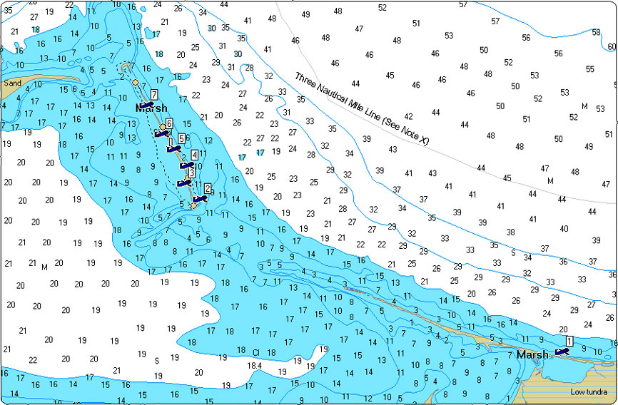 |
| Click here for a larger map.
Shipwreck remains have been discovered in the Point Franklin region, but without whaling craft associated
with the remains it's more difficult to determine if the vessel was engaged in whaling or other commercial
activities in the Arctic. Submerged shipwrecks still waiting to be discovered may offer clues to their whaling
seafaring past, with artifacts such as large iron try-pots used to render (boil) the whale blubber.
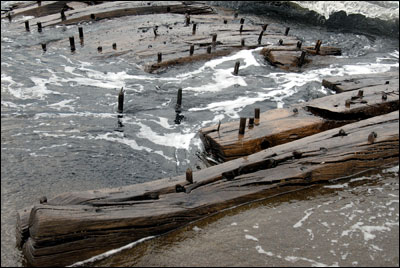 | 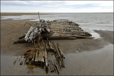 |
| Point Franklin shipwreck. Photo: Robert Schwemmer/NOAA | Point Franklin shipwreck. Photo: Robert Schwemmer/NOAA |
Captain Frederick William Beechey of the Royal Navy, wrote on August 15, 1826, "a cape, which proved
the most distant land seen from the ship, I named after Captain (Sir John) Franklin, Royal Navy, under
whose command I had the pleasure to serve on the first Polar expedition." His map shows "Point Franklin."
It is interesting to note that it was just two days later when Sir John Franklin named his "farthest point" after
Captain Beechey.
|
|
|
|