During the 2005 Hunt for the Alligator expedition, National Oceanic and Atmospheric Administration (NOAA) Maritime Heritage Program marine archaeologists and Office of Naval Research (ONR) personnel, assisted by technicians from IXSEA, Benthos, and NAVSEA, will conduct a week-long search for the lost Civil War sub off Cape Hatteras in the “Graveyard of the Atlantic.” Operating out of Ocracoke, N.C., the team will work aboard ONR’s 108-ft. “Afloat Lab” (YP-679), deploying a number of undersea search and survey tools. The Search Area
It is the intent of this year’s expedition to examine the side scan sonar targets noted during the Thomas Jefferson survey and determine if the targets represent geologic features associated with the ocean bottom or if the features have an associated magnetic signature, indicating the potential of a man-made object. To facilitate the best possible data acquisition, two different remote sensing tools will be employed in the survey. According to a letter written by the acting master (captain) of the USS Sumpter—the vessel that was towing the Alligator—to Secretary of the Navy Gideon Welles about the sub’s loss, the Sumpter cut the tow line pulling Alligator at approximately 6 p.m. Eastern Standard Time on April 2, 1863 during heavy winds and seas. The last reported position, 34.43N and 75.20W, was taken at 12 noon the same day, six hours before the tow line was cut. Winchester reported in his log that the two vessels rounded Cape Henry on April 1 and were 15 miles east-southeast of Cape Hatteras Light by 1:30 a.m. on April 2. At 5 a.m., 6 a.m. and 12 noon, the sea temperature was recorded at 68 degrees F. This temperature is inconsistent with the lat/long measurement taken at 12 noon. The captain of the Sumpter claimed he was in the Gulf Stream. However, it is highly improbable that three separate Gulf Stream temperatures would record so low. According to oceanographers, the Gulf Stream in this region would have fluctuated from the mid to upper 70s in temperature. Hence, if the temperature(s) recorded in the Sumpter’s log are correct, the latitude and longitude as recorded in the Sumpter’s log cannot be taken as fact. Taking the measurements of latitude and longitude in 1863, the most probable error would be in the calculation of longitude. Latitude would be using the angle of the sun (if they saw the sun at all). Therefore, it is possible that the Sumpter, towing the Alligator, was much farther inshore. Hence, if we keep the latitude as fact and move the longitude closer into shore until the sea temperature becomes approximately 68 degrees F (using Rutgers University Marine Remote Sensing Sea Surface Temperature estimates), the Sumpter would have been anywhere between 20-50 miles due west of the given 12 noon location. It is not disputed that the Sumpter was heading into strong gale force (35-40 knots and higher) southwest winds and heavy seas from 12 noon to 6 p.m. on April 2, 1863. According to the Sumpter’s log, the ship was making very little headway. In fact, it is possible, the Sumpter and Alligator were forced backwards with the strong winds and currents even though it appeared as though they were making "little" headway. Therefore, between 12 noon (last recorded position) and 6 p.m. (the time the Alligator was cut loose), the Sumpter and Alligator could have traveled a few miles to the southwest but it is also probable that they were pushed back several miles to the northeast. It is the intent of this year’s expedition to focus search efforts in an area southeast of Ocracoke Inlet. This area, based on the above hypothesis is located on the continental shelf in relatively shallow water (< 100 meters). To facilitate the best possible data acquisition, three different remote sensing tools will be employed in the survey. |
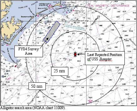 The 2005 search area is based upon research conducted by the