|
|
|
|
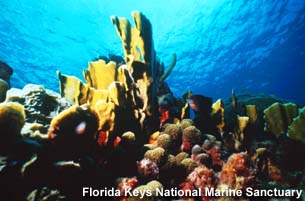
View
of an undamaged coral spur adjacent to the
grounding site depicting typical reef
biota at Looe Key Reef.
|
The
Grounding SIte
The
Looe Key Reef area contains some of the most
aesthetically valuable and heavily visited reefs in
the continental United States. Looe Key reef was
named for the remains of the British frigate the
H.M.S. Looe, which wrecked in this vicinity in
1744. It is part of the Florida Reef Tract, the
third largest barrier reef system in the world. In
1981, Looe Key National Marine Sanctuary was
Congressionally designated. This sanctuary was
formally incorporated into the larger Florida Keys
National Marine Sanctuary in July 1997. The Florida
Keys National Marine Sanctuary, managed by NOAA and
the Florida Department of Environmental Protection,
protects 2,800 square nautical miles of critical
marine habitat, including coral reef, hardbottom,
seagrass meadows, mangrove communities and sand
flats.
Threats
to the Environment
The
deterioration of the marine environment in the
Florida Keys is not a matter of debate. There is a
decline in the number of healthy corals, an
invasion of algae into the seagrass beds and onto
the reefs, declines in fisheries and fish stocks,
and an increase in coral diseases and bleaching. In
Florida Bay, reduced freshwater flow has resulted
in an increase in plankton blooms, sponge and
seagrass die-offs and fish kills. Overnutrification
of the nearshore waters from sewage is problematic.
Over 4 million people visit the Keys annually, 70%
of these spend time in the sanctuary, over 80,000
people reside in the Keys full-time--all cause some
impact. Recreational vessel registration has
increased six-fold since 1965. Damage, whether
direct, indirect, intentional or accidental hinders
the ability of marine life to recover from natural
stressors.
The
most visible and familiar physical damage results
from the carelessness or, on occasion, the
recklessness of ship captains, boaters, divers,
fishermen, divers, snorklers and beachgoers. Over
30,000 acres of seagrass have been damaged by
propellers. Direct impacts to resources also result
from careless standing on coral, improper placement
of anchors and destructive fishing methods. Over 19
acres of coral reef habitat has been damaged or
destroyed by large ship groundings. Approximately
500 groundings are reported in the sanctuary each
year. Without some intervention, the reefs in these
areas are not able to recover the hundreds of years
of growth, obliterated under the keel of a vessel.
Without some physical rebuilding of the underlying
structure, recruitment of coral and other benthic
species is handicapped by geologic time as well as
all the other stressors on the health of the reef
ecosystems.
Fortunately,
when a grounding occurs in a national marine
sanctuary, NOAA can seek damages to cover response,
injury and damage assessment, restoration and
replacement of the damaged habitat or acquisition
of equivalent habitat, and compensation of the
public for the value of the damaged resources until
full recovery.
In
1997, the University of Miami paid $3.76 million in
natural resource damage claims for the R/V
Columbus Iselin grounding, including a
$200,000 civil penalty. The settlement includes
funds for physical and biological restoration and
monitoring of the Columbus Iselin site, as well as
compensatory restoration and monitoring (such as
grounding prevention) elsewhere in the sanctuary.
(top)
The
R/V Columbus Iselin Grounding
The
Injury (August 1994)
Just
before midnight on August 10, 1994, the 155 foot
research vessel, the R/V Columbus Iselin
(Iselin), owned and operated by the University
of Miami went aground on a spur and groove coral
reef formation in the western portion of the Looe
Key National Marine Sanctuary, now part of the
Florida Keys National Marine Sanctuary. These spur
and groove formations are among the best developed
in the Florida Keys. The grounding site was 12.9 km
off the southwest tip of Big Pine Key, Florida
(24° 37'N, 81° 24'W).
|
|
|
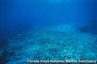
R/V
Columbus Iselin aground Looe Key
reef in the Florida Keys National Marine
Sanctuary. Note the suspended sediment
produced by the grounded
vessel.
|
The
vessel and its anchor severely injured four coral
spurs resulting in near total destruction of reef
flora and fauna at the primary impact site. In
addition to injuries at the final resting place,
the vessel created widespread injury to surviving
organisms and coral colonies throughout the
grounding track. The grounding generated
considerable coral rubble and ship debris that
rested in the sand channels and on the damaged
coral spurs in addition to dislodging and
overturning massive sections of coral. Fuel had to
be off-loaded from the vessel tanks to allow the
vessel to float and be removed from the reef. The
vessel remained on the reef over 38 hours until it
was removed by a commercial salvor working under
the direction of the U.S. Coast Guard and sanctuary
staff at 2 pm on August 12, 1994.
Injury
assessment site surveys after the vessel was
removed indicated the Iselin grounding
created six scars on the top of four coral spur
formations. The injured spurs were created over
4,000 years ago as part of the coral growth in the
Pleistocene era. The physical injury obliterated
this structure in some places, and compromised the
structural integrity of other places and increased
the risk of erosion. The grounding destroyed 163.88
square meters of living coral and 338 square meters
of the reef framework.
Along
with the physical and biological damage there were
also cultural and aesthetic losses. Dislodged
artifacts were recovered after the grounding,
altering their contextual value. The closing of the
grounding site for ship removal, rubble removal and
injury assesment resulted in lost services to
non-consumptive activities such as snorkeling and
scuba diving.
Response
to Grounding
Vessel
salvage (1994)
As
soon as the incident was reported, FKNMS staff
responded and remained on site until the
Iselin was removed. They provided technical
assistance to the U.S. Coast Guard and performed
reconnaissance dives to assess the threat of
further damage to the reefs. A commercial salvor,
under the direction of the Coast Guard and
sanctuary staff, removed the vessel.
Emergency
biological triage (August 1994)
Immediately
following the grounding, NOAA biologists thoroughly
searched the area for coral communities that could
survive if recemented immediately. Very few corals
had survived the initial impact; however, those
which did were salvaged and reattached onto nearby
reefs.
Removal
of coral rubble (Summer 1995)
|
|
|
Coarse
rubble atop injured reef spur.
|
It is estimated that more than 400 cubic meters of
dead coral rubble were created by the impact of the
Iselin on the reef. This rubble posed a threat to
the surrounding biological resources, as it moved
around with the wave action and collided with
nearby coral colonies and other benthic organisms
such as sea fans and sponges. The rubble also
buried nearby living organisms. Since it was
unstable, the rubble posed a threat to benthic
organisms that might settle on it only to be
toppled and killed later. To prevent further
damage, NOAA conducted an extensive rubble removal
project during the summer of 1995. Several tons of
rubble were removed and transported by barge to
Miami, Florida. After the rubble was sorted, all
reef rock larger than 7.62 centimeters in diameter
was transported to Key Largo, where it is being
stored for restoration of the site. The remainder
of the rubble was disposed of in an approved
disposal area.
Removal
of ship debris (August/September 1994, September
1995)
During
the grounding, several steel plates were sheered
off the hull of the Iselin and left deeply
imbedded in the sand channel. A large anchor and
other debris were left after the salvage operation
was completed. These items posed a threat to Looe
Key Reef resources. The hull sections and the
anchor were removed in September 1995 during the
rubble removal operation.
Retrieval
and conservation of exposed cultural resource
artifacts (August 1994, September
1995)
During
the initial survey of the damage, NOAA saw that
several cultural artifacts from historic shipwrecks
had been exposed when the overlying reef matrix was
destroyed. These artifacts were surveyed by a NOAA
archaeologist, collected, and secured at the site.
Later, NOAA removed a sample of the artifacts.
Artifacts were conserved according to the Federal
Archaeological Program's guidelines for
conservation and curation of maritime cultural
resources. The artifacts are currently in storage
at the sanctuary's Key West office.
Development
of a proposed restoration plan (December 1996)
In
response to the grounding and the subsequent
efforts, NOAA developed a proposed restoration plan
for the site. This plan drew on the experience
gained from restoring other grounding sites in the
area and outlined a preferred alternative for the
restoration of the Iselin grounding site.
Settlement
(December 1997)
The
University of Miami paid $3.76 million in natural
resource damage claims for the Iselin
grounding, including a $200,000 civil penalty.
(top)
Subsequent
Damage
Additional
damage to the reef occurred as a result of an
active 1998 hurricane season (e.g., Groundhog Day
Storm, Hurricane Georges, and Hurricane Mitchell).
The injury sites were severely excavated
vertically, except one spur, which suffered a
lateral loss of reef surface. On the same coral
spur, a 15-foot by 6-foot piece of the reef broke
off from the landward side. Overall, the storm
damage has deepened and expanded the injury site
due to scouring wave action. A site reconnaissance
of the damaged area was prepared in August 1997,
and bathymetric surveys of the site were completed
in October 1997 and December 1998.
|
|
|
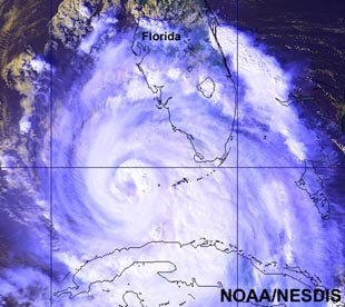
Satellite
image from NOAA/NESDIS of hurricane
Georges as the center passed over Key
West, Florida on September 25, 1998. This
hurricane caused significant additional
damage to the Looe Key reef site where the
R/V Columbus Iselin ran
aground.
|
During these storms the vulnerable sub-surface was
further scoured by storm waves. The impact of the
storms, particularly Hurricane Georges, caused
volumetric losses that almost doubled the loss from
the original incident. This underscores the
importance of being able to do restorations more
quickly, despite stalled settlement negotiations or
lack of available funds to do an entire
restoration. Emergency stabilization of the coral
substrate is critical to the prevention of further
loss of reef material.
Restoration
Plan
The
extensive physical damage caused by the
Iselin grounding (e.g., scraping, cracking
of the underlying fossil limestone) led to
extensive impacts on the habitat and biological
resources of the area. Because of this, the focus
of the restoration effort is on recreating, to the
extent practicable, preexisting habitat, structure,
depth, and surface topographical relief. This
approach will allow benthic organisms to recolonize
the area. The restoration will build on
state-of-the-art techniques developed in 1995 at
the grounding sites of the M/V Elpis and the
M/V Alec Owen Maitland off Key Largo.
Without the physical restoration efforts, the site
is likely to deteriorate further due to storm
damage and biological recovery would be extremely
slow. After the reconstruction, adult colonies of
the major resident benthic species previously
present at the site (e.g., hard corals, soft
corals, sponges, and sea mat) will be transplanted
to the re-created reef substratum. The site will be
monitored to assess the recovery and natural
recruitment processes of both benthic species like
corals and sponges, as well as fish
populations.
It
is estimated that the restoration will take
approximately 4 to 6 weeks. Boulders from a South
Dade County limestone quarry will be used. Use of a
construction barge moored on site but off the reef
tract will prevent collateral damage to the reef.
All operations will be planned and performed
according to Army Corps of Engineers and national
marine sanctuaries permit requirements.
The
proposed repair plan consists of placing limestone
boulders in the four damaged depressions in the
reef and then stabilizing the boulders with a
tremie pour of concrete around the boulders. The
limestone boulders used for the repair will range
from 3 to 5 tons, with diameters measuring
approximately 4 feet. The boulders will be bound
together by the concrete to create a single unit at
each site. A special inert type of concrete and a
process called a tremie pour prevent concrete from
flowing into the water. The construction firm will
be employing extensive procedures to minimize
turbidity. The restoration ultimately should reduce
turbidity in the area by stabilizing loose
sediments. Corrosion-resistant reinforcing fiber
glass bars (rebar) will be placed in the concrete
for improved attachment between boulder/concrete
layers. Layers will be constructed one above
another until the reef spur is restored. The large
limestone boulders will create a topography similar
to that provided by the reef spurs before the
damage occurred. The sides and surface of each
repair will include exposed surfaces of the
boulders to enhance the opportunities for benthic
recolonization of the repair area surface. The
strength of the natural reef material is such that
attachment of the repair to the natural reef by
reinforcing steel would not provide additional
stability. The repair will depend on the weight of
each unit to provide structural stability in storm
events.
Coastal
Planning and Engineering Inc., is the design
engineer for the physical restoration, and Team
Land Development, Inc. is the construction
contractor. Coastal Planning and Engineering, Inc.
has extensive marine engineering expertise,
including reef restoration work with NOAA's
Restoration Center in Puerto Rico. Team Land
Development, Inc. worked with NOAA on the
Elpis and Maitland reconstructions
and also did the rubble removal on the Columbus
Iselin site.
Safety
Concerns
Restoration
work begins July 12, 1999 and ends September 7.
(This time period includes a buffer for
weather-related delays.) Because of the safety
hazards posed by heavy equipment and construction
activity, the sanctuary is asking the public to
avoid the restoration site, located toward the
western end of Looe Key.
Site
Coordinates
24o 32' 40.3"N 81o 24' 30.6"W 24o 32' 42.3"N 81o 24' 24.5"W
24o 32' 46.9"N 81o 24' 26.3"W 24o 32' 44.8"N 81o 24' 32.4"W
Construction
markers will outline the boundaries. The sanctuary
will temporarily remove several mooring buoys
(15-19) while construction is in progress. These
buoys will be replaced after the physical
restoration is complete.
(top)
|


