Shipping Lane Shift Reduces Risks to Whales
By Anne Smrcina
NOAA Stellwagen Bank National Marine Sanctuary
 |
|
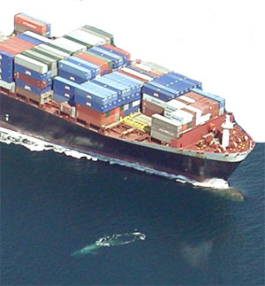
A container ship just missing a blue whale. (Photo: Julie Helmers, NOAA)
|
Staff research into reducing threats to endangered whales in Stellwagen Bank National Marine Sanctuary paid off in a big way at the close of 2006 when the International Maritime Organization approved a shift in shipping lanes in the region. The move, which will go into effect on July 1, 2007, will reduce the risk of ship strikes to critically endangered right whales by up to 58 percent and to all large whale species by up to 81 percent.
The decision stemmed from a study to identify where and when whales spend time in the sanctuary. The area is a critical seasonal feeding place ground for endangered humpback, finback and the remnant population of North Atlantic right whales (researchers believe less than 400 remain in the world). It is also an area where large, commercial ships – to the tune of nearly 200 per month - enter the Port of Boston.
 |
|
Click image for larger view.
|
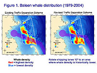
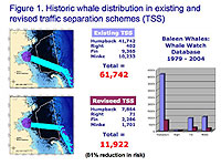
After analyzing data from 25 years of more than 250,000 whale sightings, sanctuary scientists found that humpback and finback whales congregated over certain areas of Stellwagen Bank – in particular, over sandy areas preferred by sand lance [mpg video], a small schooling fish that buries itself in the sediment. This fish species is the prey of choice for many whales and larger fish. Figure 1 shows the present and new shipping lanes and the historic whale distribution pattern.
 |
|
Click image for larger view.
|
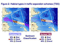
A 12-degree northward adjustment, the sanctuary scientists concluded, places the lanes over a more muddy and gravelly seafloor, away from the humpback and finback whales’ primary feeding areas over sandy bottom (Figure 2).
 |
|
Click image for larger view.
|
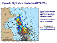
The shift also moves the shipping lanes away from areas where right whales have been known to feed on drifting copepods, small crustaceans that are a major part of the region’s zooplankton community. Studies by researchers at the University of Massachusetts, Boston of neutrally buoyant particles released in Massachusetts Bay indicate that currents on Stellwagen Bank would move the planktonic animals into or near the present shipping lanes, as well as into most of Cape Cod Bay. Figure 3 illustrates the distribution of right whales relative to the existing and revised shipping lanes.
“The decision to move the shipping lanes will significantly contribute to the safety of endangered and protected whales in the sanctuary and can be a model for similar actions in other areas,” said David Wiley, Ph.D., research coordinator for the Stellwagen Bank sanctuary and lead scientist for the study. “It’s a great example of the sanctuary working with industry to accomplish important conservation objectives.”
Wiley notes that whale sighting data provided by the Provincetown Center for Coastal Studies and the Whale Center of New England were critical to conducting the study that eventually led to the maritime organization’s decision.
Scientists conducted a risk analysis of ship strikes to whales by analyzing a 25-year database (1979 – 2004) of whale sightings from whale watch and whale research vessels and ship strike data gathered through whale necropsies and on-the-water observations. Researchers also reviewed habitat characterization data, whale feeding ecology studies, and characterizations of large commercial vessel use of the sanctuary in order to identify where and when whales spend time in the sanctuary and what areas hold the greatest threats to whale safety.
 |
|
Click image for larger view.
|
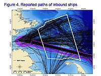
In Figure 4, data from NOAA Fisheries’ Mandatory Ship Reporting System (inbound traffic only) show large numbers of ships crossing the entire span of the sanctuary, but the highest concentration in the shipping lanes. In a comparison of the existing shipping lanes (also known as the Traffic Separation Scheme) with the new path, the numbers of historic sightings in each area is significantly different for all whales (humpback, right, fin and minke). The older lanes had a total of 61,742 sightings, while the new lanes had only 11,922 – reflecting an 81% reduction in risk (Figure 5).
 |
|
Click image for larger view.
|
“When the data were compiled, we saw obvious areas where the potential for ship strikes were likely,” said Craig MacDonald, Stellwagen Bank’s superintendent. “Through this analysis a solution became apparent, based both on sightings and ecological characterization. We are pleased that the shipping community understood the significance of these results and worked with us towards this conservation measure. By moving the lanes, we reduce the lethal threat of ship strike to these majestic creatures that are a thrilling component of the sanctuary’s biodiversity.”
 |
|
Recent decision by the International Maritime Organization will reduce collisions with whales. (Photo: Stellwagen Bank National Marine Sanctuary file photo - #981-1707)
|
|