One July 23rd, 2006, the NOAA ship Hiialakai returned to Honolulu following a 28-day research cruise to the Northwestern Hawaiian Islands. The multidisciplinary expedition included six maritime archaeologists with NOAA's National Marine Sanctuary Program conducting non-invasive survey at Kure Atoll and Pearl and Hermes Atoll. The NOAA team included: Brenda Altmeier (Florida Keys NMS), Dr. Kelly Gleason (Pacific Islands Region NMS), Tane Casserley (Maritime Heritage Program NMS), Lindsey Thomas (Hollings program intern from the University of Georgia), Robert Schwemmer (West Coast Region NMS), and Dr. Hans Van Tilburg (Pacific Islands Region NMS, principal investigator). Surveying wreck sites in the Hawaiian archipelago reveals our seafaring history and provides a platform for the message of preservation and comprehensive ocean stewardship. The Pearl is one of those opportunities.
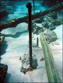 |
| Copper fasteners protrude from the oak keel in the sand, indicating the position of timbers in the bottom of the ship. A lead pipe lies to the right. (Photo: NOAA NMSP) |
|
|
Preliminary archival work on the history of the British whaler Pearl indicates that the vessel was originally built as an American ship in Philadelphia at least as early as 1805. At some time after that, the ship may have been captured by the French during the aftermath of the Quasi-war and named (renamed?) La Perla; subsequently taken by the British privateer Mayflower and from there put into service in the British South Seas whaling industry out of London. As a British whaler, the Pearl (Captain Clark) sailing with her consort whaler Hermes, struck an unknown reef on the night of April 24th, 1822. The two ships had been making a passage from Honolulu to the newly discovered Japan Grounds, a track which took them through the uncharted Northwestern Hawaiian Islands. The combined crews made it safely to one of the small islands, salvaging provisions and timbers for the construction of the 30-ton schooner. However, before launching the beach-built rescue vessel Deliverance, the ship Earl of Morby was sighted. The castaways were rescued. Twelve of the sailors, including chief carpenter James Robinson, elected to purchase and sail the Deliverance back to Honolulu themselves. James Robinson later started the first shipyard at Honolulu in 1827.
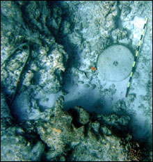 |
| The stone grinding wheel, once used to sharpen whaling tools, lies near the site baseline. To the left, the ship's gudgeon from the sternpost. (Photo: NOAA NMSP) |
|
|
The site was found by NOAA divers in 2004. The Coral Reef Ecosystem Division of NOAA's Pacific Island Fisheries Science Center has supported the removal of drift fishing nets from the fragile reefs of the Northwestern Hawaiian Islands for a number of years. Annually, teams of "marine debris" divers visually survey high impact zones in the distant atolls, cutting these nets away and removing them. The wreck sites of the whalers Pearl and Hermes were discovered during one of the net removal missions.
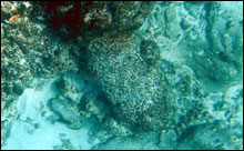 |
| One of two cannons found in the immediate vicinity of the site, trunnion middle-right of picture, bore extending underneath another concretion of artifacts. 10cm increment scale. (Photo: NOAA NMSP) |
|
|
Documentation of the Pearl site provides a glimpse of this wrecking event and the very early whaling technology in the Pacific. The Pearl and the Hermes (wrecked to the west of the Pearl) are the only known British South Sea whaling wreck sites in the world. Individual artifacts at this high energy site are quite deteriorated, but their distribution and superposition (vertical order) provide some of the site interpretation. The oak keel ground into the shallow sand channel, and distorted copper hull sheathing pieces pressed into the adjacent coral substrate, delineate the resting place of the ship. Large copper fasteners have been caught in depressions in the reef, or still emerge vertically from the wooden keel. Four large iron try pots, fallen through the decks, now trap sections of hull sheathing, indicating that they fell through the ship as it deteriorated, the vessel falling apart where it initially grounded.
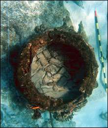 |
| Plan view perspective of try pot, bricks inside the cauldron, portions of torn hull sheathing trapped underneath. (Photo: NOAA NMSP) |
|
|
These pots once rendered the whale blubber into oil. Anchors (not deployed) pinpoint the bow of the vessel towards the reef, gudgeon or sternpost hardware near what was the stern to seaward. Inshore a large anchor was set, possibly to hold the stricken vessel in place after the wrecking. Two cannon lie on the main site, indicating the nature of hazards faced during early 19th century whaling voyages to the Pacific. Ballast and fasteners and bricks are strewn about as well. Much of the iron and sheathing artifacts are literally embedded in the calcareous algae, fixed firmly in place. Due to the extremely rare nature of British South Sea whaling wreck sites, and the wide variety of this site's material culture, this resource has high potential for nomination to the National Register.
Site environment is challenging to any type of survey work. The wreck of the Pearl lies seaward of the reef crest, but in the proximity of the surf zone. At the northern end of the site the substrate grows shallow (12 feet) and wave action can render this end unworkable, while divers at the southern end of the site are slightly deeper and more able to continue survey. Just to the east of the site is a high shoal area (spur) of reef substrate, which breaks frequently. Dive boats must "live boat" in order to remain safely in the shoulder of the breakers and avoid occasional large sets which roll over the site. Divers on the site can expect 10-15 feet of horizontal surge on the bottom, and breakers rolling over their heads. There is minimal coral cover. The site is only accessible during good weather.
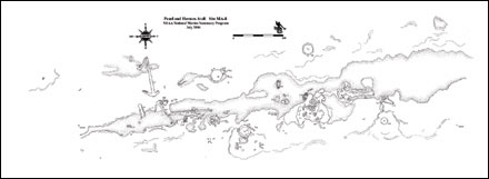 |
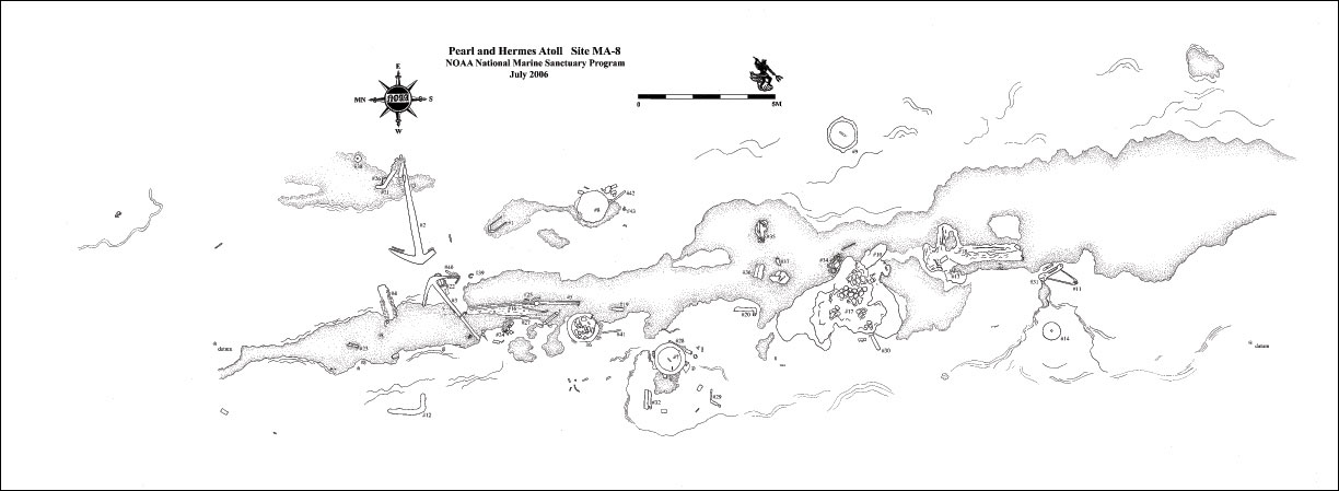
| The site plan of MA-8 at Pearl and Hermes Atoll. Click here for a larger image. (Photo: NOAA NMSP) |
|
|
This site lies within state waters, as well as the management areas of the Hawaiian Islands National Wildlife Refuge and the Northwestern Hawaiian Islands Marine National Monument. The underwater survey of the Pearl site provides images and data to be shared with the public. The survey also completes the in situ artifact inventory for the purposes of monitoring and management of this protected and rare resource. The Pearl is one of ten known whale ship losses within the Northwestern Hawaiian Islands, a region renowned for its pristine beauty and natural resources, and its historical and cultural significance for Hawaii and the Pacific region.

Additional Resources and Links
Northwestern Hawaiian Islands Marine National Monument
To learn more about the expedition click here.
Hawaii Department of Land and Natural Resources
NOAA Pacific Islands Fisheries Science Center
U.S. Fish and Wildlife Service Pacific/Remote Islands National Wildlife Refuge Complex
|


