Error processing SSI file
The 2010 Scientific Expedition to Titanic
In August 2010, The Office of National Marine Sanctuaries joined a coalition of government and private partners to conduct a comprehensive scientific mapping of the entire Titanic wreck site. The mission, organized and funded by RMS Titanic, Inc., included the Advanced Imaging and Visualization Laboratory of Woods Hole Oceanographic Institute, the National Park Service's Submerged Resources Center, the Institute of Nautical Archaeology, the Waitt Institute and contracted partners such as Phoenix International, Ltd. Dr. David Gallo of Woods Hole was the expedition leader, Dr. James Delgado, director of ONMS' Maritime Heritage Program, was the chief scientist and was principal archaeological investigator along with the NPS's chief of the Submerged Resources Center, Dr. David Conlin. William Lange, the director of the AIVL at Woods Hole, was the principal investigator for the documentation of the site. Together, the team crafted an archaeological research design for the 2010 mission. of Woods Hole Oceanographic Institute, the National Park Service's Submerged Resources Center, the Institute of Nautical Archaeology, the Waitt Institute and contracted partners such as Phoenix International, Ltd. Dr. David Gallo of Woods Hole was the expedition leader, Dr. James Delgado, director of ONMS' Maritime Heritage Program, was the chief scientist and was principal archaeological investigator along with the NPS's chief of the Submerged Resources Center, Dr. David Conlin. William Lange, the director of the AIVL at Woods Hole, was the principal investigator for the documentation of the site. Together, the team crafted an archaeological research design for the 2010 mission.
The mission's primary goal was a detailed archaeological map of the entire site - every scattered artifact and section of hull that rests on the sea bed, 12,467 feet, two and a half miles, or 3800 meters beneath the surface of the North Atlantic. In the 25 years since Titanic's discovery, an increasingly detailed sense of areas of the site, such as the more or less intact bow section, had been accomplished through the work of many expeditions, including those of Dr. Robert Ballard, James Cameron, NOAA, RMS Titanic, Inc., and documentary film makers such as Discovery and the History Channel. But a comprehensive map that would allow for a virtual catalogue of everything at the wreck site, as well as a forensic reconstruction of how Titanic broke apart and fell to the bottom of the sea had not been done. This was a key goal for all of the partners. RMS Titanic, Inc. was also interested in using the two-dimensional and three-dimensional images of the wreck to "virtually raise" Titanic and make them available to the public. ONMS shares that goal, with its own strong commitment to and initiatives in public outreach and education.
For the Office of National Marine Sanctuaries, with its Congressional and Court-mandated responsibilities for the wreck site, another goal was utilizing the mapping to also recommend appropriate future dives and research at the site, to assess future change (including possible damage or unauthorized removal of artifacts) and to work with the other partners and data from past expeditions to determine how fast Titanic is changing. An ongoing question in both the academic and public arenas is whether Titanic is rapidly deteriorating and if it will be soon be a pile of rust on the sea floor. Creating a comprehensive visual, three dimensional map of the wreck, and then adding images captured by various expeditions over the past 25 years (before 2010) would provide a measured, and obvious sense of change to go along with the scientific analysis of steel samples and the bacteria that is suspected to be consuming parts of the hull. To assist in this portion of the mission, ONMS was also represented on the expedition by David Alberg, the superintendent of USS Monitor National Marine Sanctuary. Alberg's extensive experience in managing the 1862 iron wreck of Monitor, the first National Marine Sanctuary and like Titanic an iconic ship, made him the right person for this aspect of the mission.
The 2010 mission, with a non-recovery, do-not-touch scientific focus, focused on William Lange and the WHOI Advanced Imaging and Visualization Laboratory's work to create a detailed 2D and 3D visual mosaic of the site, as well as the detailed survey utilizing the Waitt Institute's REMUS 6000 autonomous underwater vehicles of an approximately 10 square nautical mile survey zone around the wreck site, with a series of closer, higher resolution surveys of the area delineated in the 1986 WHOI map of the site and even closer surveys of key features and areas of the site. That project was successful in generating the mapping data as well as comprehensive visual coverage of the wreck, including detailed photo mosaics of a number of features in the artifact scatter including sections of the ship's hull, machinery and equipment as well as other artifacts. It is to date the most detailed depiction of the Titanic site, and it is the basis for a detailed archaeological site map currently being completed with a 2013 date as terabytes of data are processed. Preliminary results will be released publicly in April 2012.
Results of the 2010 Mission
Previous expeditions to Titanic have noted the presence of "modern" materials on the wreck site, including memorial plaques, equipment from submersibles dives and recovery operations, and garbage. There is also one modern interment, the ashes of Florida treasure hunter Mel Fisher, resting on the bridge of the ship. There are also a number of submersible "drop weights" or ballast from a number of expeditions throughout the site. These weights, critical equipment for the sub dives, must be jettisoned to allow the submersibles and their passengers to return to the surface.
The 2004 NOAA mission to Titanic with Dr. Robert Ballard documented some of these items:
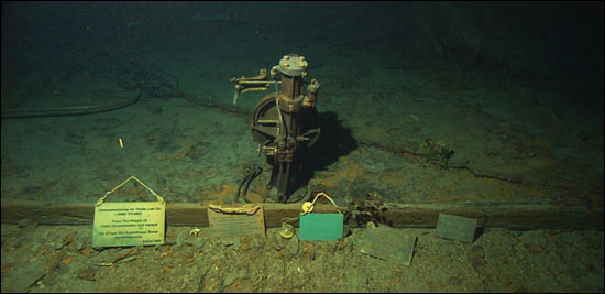
Titanic's bridge with memorial plaques and Mr. Fisher's ashes, 2004. Behind them are a U.S. flag and plastic flowers left by an expedition to the site. (Institute for Exploration/Center for Ocean Exploration at the University of Rhode Island) |
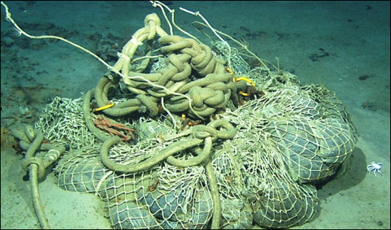
Sand bags, line and mesh on the site, 2004. (Institute for Exploration/Center for Ocean Exploration at the University of Rhode Island) |
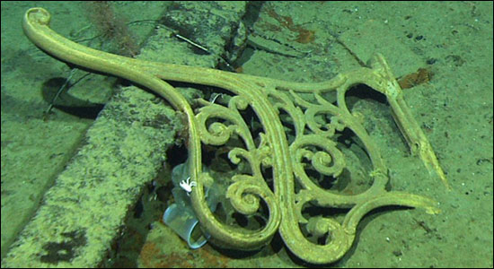
Plastic cup wedged beneath the side of a deck bench, 2004. (Institute for Exploration/Center for Ocean Exploration at the University of Rhode Island) |
The 2010 mission noted the same items as well as what appears to be a beer can next to the remains of one of Titanic's funnels.
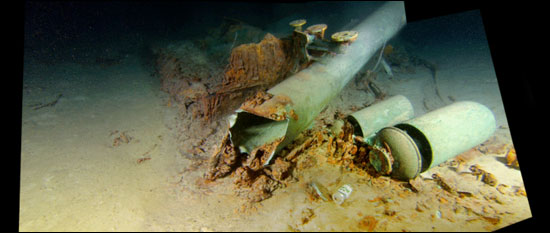
Just off the whistles, a modern metal beer can has come to rest on the seabed. (Image by Woods Hole Advanced Imaging Laboratory, Courtesy of RMS Titanic, Ltd)
|
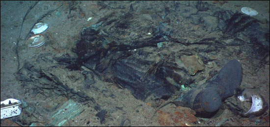
The presence of modern materials, especially garbage, is a matter of concern. The location of the wreck in deep water should not be a factor in how we treat the site. It is an archaeological site, a memorial and it is visited both by submersible divers and remote technology. Titanic is accessible by these means to the public. Titanic should be accorded the same respect as a site such as Gettysburg. This is particularly important in that unlike a site like Gettysburg, the results of the Titanic disaster remain in their original context, including what appear to be where victims came to rest.
In this image, released by Dr. Ballard in 2004, what seems to be a heavy coat with a work or sea boot protruding from beneath its seam suggests that this is where someone came to rest on the bottom. Should we dump modern garbage on such a site?
In response to this issue, and with the impending 2012 anniversary of the sinking, with a number of anticipated visits to the wreck site, including submersible dives by tourists, NOAA worked with the U.S. Coast Guard, the lead Federal agency representing the United States in the International Maritime Organization, as well as the National Park Service and Woods Hole Oceanographic Institution to create a voluntary exclusion zone for dumping, discharge and disposal around the Titanic site, and to establish zones on the site in non-sensitive areas where submersibles could land, and depart from the wreck, as well as where their "drop weight" ballast can be deposited as they begin their ascent to the surface. The text of the Coast Guard's letter to the IMO can be found
here  . .
Proposed (and voluntary) exclusion zone the letter recommends .
Here is the recommended submersible landing and departure zone map .
Archaeological Results
Archaeological analysis continues and a final report will be published in 2013. Terabytes of data are being processed and that takes time. As well, all imagery is currently held by RMS Titanic, Inc. and their media partners who funded the 2010 expedition. They will publicly release the images in April 2012. Following this, NOAA will share preliminary archaeological results and observations.
|