Error processing SSI file
|
Mission Blog: August 14, 2008
The Gledstanes and Beyond
By Dee O'Regan, Editor, Sea History Magazine
National Maritime Historical Society
Six archaeologists, one film-maker, three
shipwreck sites, one day. The
adrenalin from yesterday’s big discovery of the shipwreck
site of the British whaler Gledstanes was still running strong this
morning as we loaded the small boat for another day of diving. The
search for this site had been on our original work plan for Kure Atoll,
but no one could have anticipated we’d find it and so
quickly. In 2002, when Dr. Hans Van Tilburg began studying historical
records for information on USS Saginaw’s wrecking event of
1870, he located a hand-drawn map that Saginaw’s survivors
had made noting the location of the whaler Gledstanes on the east side
of the atoll. Armed with an historical chart, notes, and a hand-held
GPS, the team searched the spot thought most likely to hold the remains
of the ship. After preliminary surface surveys, one dive and there it
was. Remarkable.
 |
|
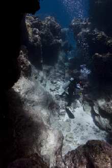
The
spur and groove topography of the Gledstones site
is beautiful and dramatic.
|
This morning we started with a short detour back
to the USS Saginaw site so that our film-maker, Stephani Gordon, could
get some footage of the paddlewheel shafts and hubs. This allowed the
rest of the team a chance to check out this part of Saginaw’s
wreck site and to get some specific measurements on the components of
the paddlewheels.
Then it was back to Gledstanes, as we were all
eager to investigate it further. This part of the reef is strikingly
beautiful. The narrow sandy grooves heading into the shallows of the
reef are defined by steep ridges of coral on either side. Small piles
of ballast lie in these outside sandy grooves in a path that leads
toward the reef, where the coral ridges come together in a confusion of
underwater cliffs and arches. This is where the heavier components of
the wreck lie—the anchors, cannon, and some heavy iron bands
and bars. Past the last anchor is the location of the trypot, nearly
buried in the sand and coral. We returned to the trypot for a series of
photographs and a measured drawing of the pot and surrounding
artifacts. Even though the sea conditions have been
uncharacteristically calm, even small swells build in the shallows and
can toss divers around a bit. The site is long and narrow, and the
buddy teams finished up their assigned tasks in a single dive. Some of
us, perhaps unwilling to say goodbye to our exciting find, did one last
snorkel around the area for a last look and to see if we’d
missed any outlying artifacts.
 |
|
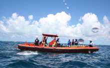
The
team enjoys lunch aboard HI-1, our daily transport
to all the shipwreck sites.
|
The day was not done, however. On the way back to
Hi’ialakai, we made a stop by Dunnottar Castle for a
reconnaissance dive, so we could make a plan for tomorrow to make the
best use of our one day left of diving at Kure Atoll. As the afternoon
sun began to descend, we swam across the huge area that this massive
sailing ship, albeit a broken ship, now occupies. It is indeed huge.
Dunnottar Castle was a 258-ft. riveted iron hull sailing ship,
reminiscent of San Diego’s Star of India and San
Francisco’s Balclutha and Honolulu’s Falls of
Clyde. In about 25 feet of water, there are iron ship parts everywhere.
We will return to Dunnottar Castle tomorrow and make the best
preliminary site plan we can in our limited amount of time. Our hope is
to set a baseline and map the most recognizable features so that future
archaeologists who return here can continue the work we’ll
start tomorrow.
All in all, a long day but a productive day in the
spectacularly beautiful environment of Kure Atoll.
To ask us questions, you can email the team at: sanctuaries@noaa.gov
and we will answer your questions within the blog, or in a live
internet broadcast later in the cruise. Again, stay tuned for details.
|