Error processing SSI file
|
Expedition to the Dry Tortugas 2009 - Florida Keys National Marine Sanctuary
September 22 - 30, 2009
Join the expedition led by a team of researchers from NOAA’s Center for Coastal Fisheries and Habitat Research aboard the NOAA Ship Nancy Foster as they head back to the Dry Tortugas.
This mission provides coastal managers with scientific information and tools to make informed stewardship decisions about one of NOAA’s protected areas—the Tortugas North Ecological Reserve. The Reserve was designated in July 2001 to protect and preserve the diverse marine life and special habitats in critical areas of the Florida Keys National Marine Sanctuary. In doing this, NOAA strives to balance society’s environmental, social, and economic goals.
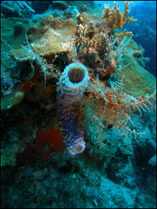 |
| Tube sponge and corals. (Photo: NOAA CCFHR) |
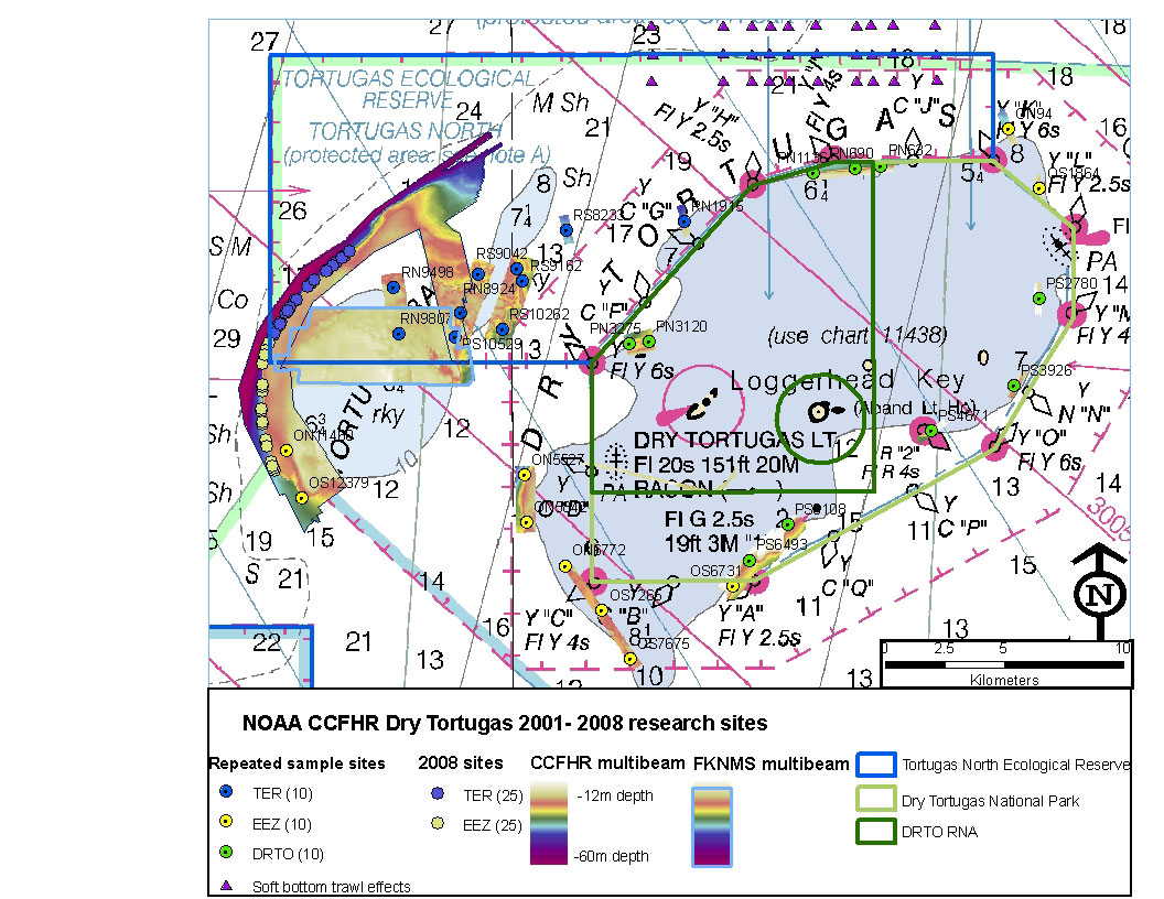
The Reserve, located west of the Dry Tortugas National Park, has an area of 90 square nautical miles. It includes the coral reefs of the Tortugas Banks and the soft-bottom habitats of the West Florida Shelf. An ecological reserve is one type of marine zoning intended to protect habitats and the species using those habitats - an element of marine spatial planning.
For nearly ten years, the research team, with help from crew and NOAA Corps officers aboard the NOAA Ship Nancy Foster, monitored fish and their habitats through diver surveys, hi-resolution underwater photography and sophisticated sonar.
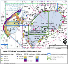 |
| Study Sites. Click here for a larger image. (Photo: NOAA CCFHR) |
Read their daily logs as they conduct research to examine habitat utilization of fishes by sampling both on and off the reef, focusing on the deep edge of the reef where it transitions into sand.
During our 2009 research cruise, we plan to revisit all our permanent stations from reef and soft-bottom habitats of the Tortugas. This will increase the fish and habitat data set that describes changes through time. We also plan to sample a portion of the Tortugas Banks that is still undescribed. Using multibeam sonar, we intend to develop a detailed contour map of the sea floor. Our split-beam sonar system will show how fishes are distributed relative to this landscape. Where the boundary bisects this area of the Tortugas Banks, divers will provide a detailed description of the distribution of benthic resources. Such data on the distribution and trends of natural resources is critical to understanding how establishment of the Tortugas Ecological Reserve has affected the ecological balance of the region.
Visit these links to learn more about the entities described on these expedition pages:
National Centers for Coastal Ocean Science
National Marine Sanctuary Program
Florida Keys National Marine Sanctuary
Center for Coastal Fisheries and Habitat Research
NOAA’s Ecosystem Research Program
Florida Fish and Wildlife Conservation Commission
NOAA’s Coral Reef Conservation Program
Center for Coastal Monitoring and Assessment
Dry Tortugas National Park
Cape Fear Community College, Marine Technology
|


