Potentially Polluting Wrecks in U.S. Waters
Home | Wreck Reports | Wrecks by District
There are concerns about potential environmental impacts from eventual release of cargo and fuel from the 20,000 shipwrecks in U.S.waters. Although a few, such as the U.S.S. Mississinewa and the Jacob Luckenbach, are well-publicized oil pollution threats, most wrecks, unless they pose an immediate pollution threat or impede navigation, are left alone and are largely forgotten until they begin to leak, often becoming the source of "mystery spills" that harm coastal economies and environments.
On May 20th, 2013, NOAA presented the U.S. Coast Guard a national report that finds 36 sunken vessels scattered across the U.S. seafloor could pose an oil pollution threat to the nation's coastal and marine resources. Of those, 17 were recommended for further assessment and potential removal of both fuel oil and oil cargo. The report ( , 9.7MB), part of NOAA's Remediation of Underwater Legacy Environmental Threats (RULET) project, identifies the location and nature of potential sources of oil pollution from sunken vessels. Knowing where these vessels are helps oil response planning efforts and may help in the investigation of reported mystery spills--sightings of oil where a source is not immediately known or suspected. The sunken vessels are a legacy of more than a century of U.S. commerce and warfare. The scope of the problem is much more manageable than initially thought. With this assessment we can put reliable bounds on the potential oil pollution threats and start to plan accordingly. The distribution of vessels is skewed heavily to World War II casualties in the Battle of the Atlantic. Some of these vessels may be eligible for listing under the National Register of Historic Places, in addition, many of them are either civilian or military gravesites. While the Great Lakes are known for their heavy toll on maritime commerce, coal was used more frequently as a fuel and the larger casualties in the Lakes were coal fired. , 9.7MB), part of NOAA's Remediation of Underwater Legacy Environmental Threats (RULET) project, identifies the location and nature of potential sources of oil pollution from sunken vessels. Knowing where these vessels are helps oil response planning efforts and may help in the investigation of reported mystery spills--sightings of oil where a source is not immediately known or suspected. The sunken vessels are a legacy of more than a century of U.S. commerce and warfare. The scope of the problem is much more manageable than initially thought. With this assessment we can put reliable bounds on the potential oil pollution threats and start to plan accordingly. The distribution of vessels is skewed heavily to World War II casualties in the Battle of the Atlantic. Some of these vessels may be eligible for listing under the National Register of Historic Places, in addition, many of them are either civilian or military gravesites. While the Great Lakes are known for their heavy toll on maritime commerce, coal was used more frequently as a fuel and the larger casualties in the Lakes were coal fired.
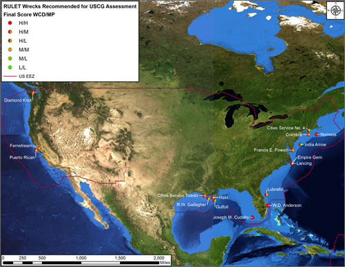 | | The locations of the 17 wrecks NOAA is recommending be considered for in water assessment and pollution recovery if necessary. |
In 2010, Congress appropriated $1 million for NOAA to identify the most ecologically and economically significant potentially polluting wrecks in U.S. waters. NOAA worked closely with the U.S. Coast Guard Office of Marine Environmental Response Policy in implementing this mandate. The Remediation of Underwater Legacy Environmental Threats (RULET) effort supported by these funds provides information that assists the U.S. Coast Guard and the Regional Response Teams (RRTs) as well as NOAA in prioritizing potential threats to coastal resources while at the same time assessing the historical and cultural significance of these nonrenewable cultural resources. The report summarizes this oil pollution threat assessment process and scores vessels based on a broad multi-disciplinary, weight-of-evidence approach that combines the historical evidence, archaeological interpretation, and salvage engineering with pollutant fate modeling, and ecological and socio-economic risk assessment. The 87 individual wreck risk assessments are available here.
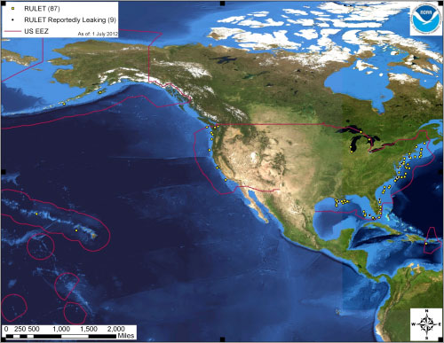 | | The locations of the 87 wrecks addressed in the national risk assessment. |
Only a fraction of the estimated 20,000 shipwrecks in U.S. waters are likely to contain oil. Many older wrecks were coal-fired or sailing ships and never carried oil as fuel or cargo. More contemporary ships often came to a violent end, breaking apart in storms, collisions, or in battle. Many shallow wrecks were salvaged or were deemed hazards to navigation and intentionally destroyed. Others sank off the continental shelf and were never located. All have suffered from corrosion and the passage of time. The National Oceanic and Atmospheric Administration (NOAA) maintains a large internal database of shipwrecks, dumpsites, navigational obstructions, underwater archaeological sites, and other underwater cultural resources. This internal database, Resources and Undersea Threats (RUST), includes approximately 20,000 shipwrecks in U.S. waters.
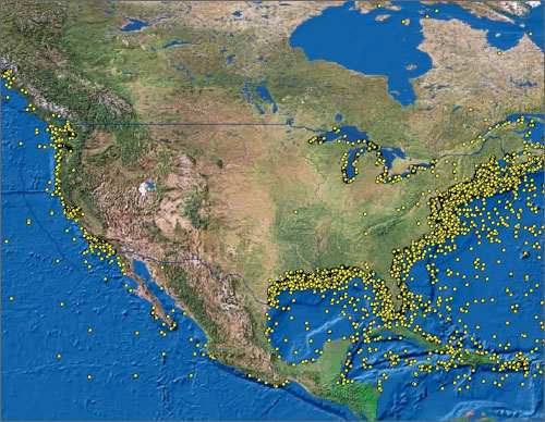 | | Over 20,000 shipwrecks exist in U.S. waters. |
How Many Really Contain Oil?
NOAA used a tiered approach to develop an initial priority list of vessels for risk assessment. This process narrowed down the 20,000 vessels in US waters to 573 that met the initial criteria. Additional research revealed that the actual number of wrecks posing a substantial pollution threat was much lower (107) due to the violent nature in which some ships sank and the structural reduction and demolition of those that were navigational hazards. A total of 87 risk assessment packages were developed for USCG. Based on vessel contents, condition, environmental sensitivity and other factors, NOAA has determined that 6 vessels are high priority for a Most Probable (10%) discharge, and 36 are high priority for a Worst Case Discharge of the 20,000 wrecks in US waters.
Overall results of the assessment for Worst Case Discharge (WCD) and Most Probable Discharge (MP).
| Category Rank | No. Wrecks for Worst Case Discharge | No. of Wrecks for Most Probable Discharge |
| High Priority | 36 | 6 |
| Medium Priority | 40 | 36 |
| Low Priority | 11 | 45 |
Types of NOAA recommendations
| Vessel Scores |
Possible NOAA Recommendations |
Number of Vessels Receiving Recommendation |
High
(+1 Medium)
|
Wreck should be considered for further assessment to determine the vessel condition, amount of oil onboard, and feasibility of oil removal action |
17 |
| High & Medium (Unknown Loc.)
|
Use surveys of opportunity to attempt to locate this vessel and gather more information on the vessel condition |
46 |
| High & Medium
|
Conduct active monitoring to look for releases or changes in rates of releases |
22 |
| All
|
Be noted in the Area Contingency Plans so that if a mystery spill is reported in the general area, this vessel could be investigated as a source |
87 |
| All
|
Conduct outreach efforts with the technical and recreational dive community as well as commercial and recreational fishermen who frequent the area, to gain awareness of changes in the site |
87 |
These are recommendations; the final determination of what type of action, if any, rests with the U.S. Coast Guard under authority from the National Contingency Plan and the Oil Pollution Act of 1990. As the risk assessments are incorporated into regional and area contingency plans, it is likely that local knowledge will bring forward other vessels that meet the criteria that the U.S. Coast Guard can apply the RULET methodology to as well.
An example of one of the scoring sheets can be found here.
The majority of the 36 higher risk wrecks identified in RULET are located off the North Carolina and Florida coasts. They reflect the intensity of World War II casualties in the Battle of the Atlantic. For the 6 Most Probable Discharge(10%) scenario, the high priority wrecks are located off of New England and Florida.
The findings presented here are preliminary and are intended to provide input for Area Contingency Plans. Those vessels considered to be potentially high-risk based on the best available data and modeling results would be candidates for further investigation, including on-site surveys, to validate assumptions about vessel condition, oil content, oil type, and other factors that would weigh into an informed wreck-specific response decision. Small wrecks were excluded from the analysis, but these may be locally significant sources of pollution. There are likely still significant potentially polluting wrecks that have not been discovered or evaluated during the NOAA assessment.. Historical information used in our analysis is often incomplete with records based on subjective witness statements often made during or just after times of great stress. Information was certainly lost in the fog of time and warfare. A ship's cargo or bunkers may have been reported incorrectly, or confused with another vessel or voyage. However, we believe that the combination of the historical data, archaeological information, salvage engineering, and environmental modeling information here provides a strong basis for future actions and decision-making and allows U.S. Coast Guard FOSCs, RRTs, and local Area Committees to evaluate the local and regional risks that may be associated with these vessels in the context of other pollution threats within their areas of responsibility.
Each of the 87 wreck specific reports contains an overall score and preliminary, vessel-specific recommendations for further action, ranging from awareness within the local response community, to monitoring, to further assessment and planning for underwater remediation. In most cases the vessel's position, condition and orientation are only generally known. ROV or other underwater surveys will be necessary to determine the vessel's structural integrity and potential for oil remaining onboard.
|