|
 Sanctuary Turns Twenty-Five Sanctuary Turns Twenty-Five
The site hosted events throughout the year to educate the public about its ocean conservation, research and education accomplishments from the last 25 years and plans for the sanctuary’s future. These accomplishments include a prohibition on oil and gas drilling in sanctuary waters, an increase in the blue whale population, discovery and documentation of shipwrecks, educating thousands of children, the acquisition of a state-of-the-art research vessel, more than 100,000 hours of service by community volunteers, and the establishment of the largest network of fully protected marine reserves on the west coast.
Scientists Study Effects of Marine Protected Areas Network
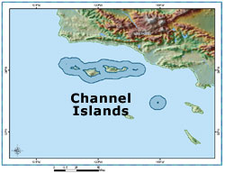
Scientists completed remotely operated vehicle surveys in October 2005 that explored several Channel Islands marine protected areas (MPAs) and quantified fish abundance inside and outside the protected areas. In 2003, 12 areas were set aside to protect and enhance Channel Islands marine life.
The cruise was conducted in partnership with the California Department of Fish and Game and Marine Applied Research and Exploration and is part of the marine reserves and conservation areas monitoring plan. The science team completed surveys in all ten planned survey sites and completed 120km of transects (20km more than planned). Transects were completed inside and outside MPAs at San Miguel, Santa Rosa, Santa Cruz, and Anacapa Islands.
In addition, sanctuary staff, in partnership with scientists from U.C. Santa Barbara's Marine Science Institute, also completed a cruise using the submersible Delta. This cruise was part of the monitoring plan for the deep-water portions of existing and proposed marine reserves and conservation areas. One major goal of this cruise was to use the submersible to conduct habitat and fish surveys over areas recently surveyed by remotely operated vehicles (ROV) to compare data collected using these two methods. Researchers want to ensure that data will be comparable between Delta Submersible observations and ROV observations. The advantage of using the Delta submersible is it can operate in deeper waters (up to 225 feet).
Twenty-three transects (approximately 16.5km) were completed inside reserves at Anacapa Island, repeating the same transect lines surveyed using the ROV. Another 23 transects (approximately 14.5km) were completed at the Gull island reserve, where the ROV had also surveyed. A highlight of this cruise was surveys conducted on Footprint Reef, a very important habitat for many rockfish species south of Anacapa Island. The reef is proposed as a marine reserve or marine conservation area. Scientists explored two unique geologic features in the area, the Footprint Ridge and the Piggy Bank. During the cruise, scientists recorded video and photographs of three extremely rare rockfishes (the bronze-spotted, chameleon, and semaphore).
Results from both cruises will be available on the Channel Islands sanctuary Web site later this year.
White Abalone Restoration Project Continues
Sanctuary staff are supporting the California Department of Fish and Game in its efforts to enhance white abalone populations in the Channel Islands. Working aboard the sanctuary program's research vessel Shearwater, scientists collected abalone to increase the number of breeding size adults in captivity.
White abalone are a deep water, marine snail found between 80 and 200 feet on rocky reefs from Point Conception in California to Punta Abreojos in Baja California, Mexico. They are listed as endangered under the Endangered Species Act, and this project supports recovery efforts of the National Marine Fisheries Service's Office of Protected Resources. Scientists on-board conducted several ROV dives to locate areas of suitable white abalone habitat and, whenever possible, to collect abalone specimens. Traps were deployed to collect additional specimens, in an attempt to increase the number of brood stock in captivity. At the completion of the project, three abalones had been collected and several hours of underwater video recorded, exceeding the initial goals of the project. Eventually, scientists hope to introduce captive-bred animals to the wild, in the hopes of restoring local populations.
A component of the project included taking students and faculty from Oxnard College and Channel Islands Marine Resource Institute out to Santa Cruz Island to monitor white abalone habitat modules. Student interns worked alongside Channel Islands National Park divers and researchers to record size and abundance of transplanted white abalone in four underwater habitat modules. Divers used audio and video systems to communicate with the students on the surface as they worked underwater. This program is in support of a new, 5-year NOAA Minority Serving Institution and Environmental Partnership Program Grant that the Channel Islands Marine Resource Institute and Oxnard College were recently awarded. Oxnard college students receive formal training in Oxnard College's Marine Studies Program, while observing white abalone at Channel Islands Marine Resource Institute's hatchery. Students are also given opportunities to participate in monitoring the reintroduction of the endangered white abalone. Additional student monitoring cruises are planned for 2006.
Scientists Document Gas Amounts Escaping From Seep Fields
Scientists observed a significant increase in the oil and gas seepage from the Coal Oil Point seep field located in the northern Santa Barbara Channel. The seep field is one of the largest in the world and by far the dominant oil source in the channel. It is likely that the extensive oiling of birds observed this winter was a result of the increased seepage. The results of the study conducted by scientists at the University of California at Santa Barbara will help managers to monitor effects of the seepage or other natural or human-caused activities on wildlife over time.
New Sea Center Focuses on Marine Conservation
Visitors and local residents can now visit a world-class education and research facility at Stearns Wharf in Santa Barbara. The Ty Warner Sea Center, which is owned and managed by the Santa Barbara Museum of Natural History, focuses on marine conservation within the Channel Islands region. While the facility welcomes all ages, its exhibits and programs are primarily focused on elementary school students. The sanctuary funded a major exhibit and interactive kiosk in the Sea Center, which highlights NOAA weather and sanctuary information. The center received 70,000 visitors in its first eight months.
Exclusive Stories for the Web
Tiny Instruments Help Locate Shipwrecks
Marine scientists and researchers working in the national marine sanctuaries are always looking for new and better ways to improve our understanding of the ocean world. Their efforts and the application of improved technology, leads to more effective ways to make necessary management decisions that enhance the future of the sanctuaries and of our maritime cultural heritage. And sometimes, the biggest strides in science and exploration come from the tiniest of instruments. Click here for the full story and see a short video on divers exploring the wreck.Volunteers Led The Way in the Channel Islands
Channel Islands Naturalist Corps, established in 2001, are a group of volunteer, ocean stewards dedicated to educating passengers on board whale watch vessels visiting Channel Islands sanctuary and the Channel Islands National Park. Volunteers participating in the program are trained to educate the community about the cultural and biological resources found on the five Channel Islands and sanctuary waters surrounding the islands.
Naturalist Corps volunteers educate local school children, residents, and tourists, monitor sanctuary and park resources, and conduct research on board local whale watch vessels departing out of Santa Barbara Harbor, Ventura Harbor, and Channel Islands Harbor. The field season runs from January to October, which captures the presence of migrating gray whales and foraging blue and humpback whales. In addition to field interpretation and research, volunteers also offer slide presentations for local schools and community groups and represent the sanctuary and park at marine-related community events.
Volunteers receive training from scientists and other experts in the field of marine science, marine mammals, seabirds, island ecology, oceanography, geology, and cultural history of the Santa Barbara Channel. Please visit the Naturalist Corps Web page to learn about how to become a volunteer at the Channel Islands.
Channel Islands Argonauts Explore the Channel Islands
The 2004-2005 Channel Islands Argonauts, an elite group of underserved 5th-8th grade students and their parents and teachers participated in a cruise aboard the R/V Shearwater on April 23, 2005 to Anacapa Island in the sanctuary and Channel Islands National Park. Undergraduate students from the University of California, Santa Barbara Marine Science Institute offered a hands-on touch tank with invertebrates and other intertidal life on the back deck of the Shearwater. The group also participated in an island hike lead by a member of the Channel Islands Naturalist Corps, and paddled a Tomol (Chumash wood plank canoe) as part of their experience. On the cruise out to the Channel Islands, argonauts, parents and teachers joined staff in collecting data from marine mammal sightings.
Sanctuary Supports Third Tomol Crossing
Sanctuary staff supported the local Chumash Community's third Tomol crossing in recent years. The Tomol is a handmade wooden canoe that carries four to six paddlers at a time and is over twenty feet in length. The crossing to the Chumash's native homeland of Santa Cruz Island from Channel Islands Harbor occurred on September 10 and was completed in about eleven hours. Staff supported the crossing on with the research vessel R/V Xantu. When the Tomol reached Santa Cruz Island, it was welcomed by more than 100 cheering members of the Chumash Community singing native Chumash songs.
 Plans for 2006 Plans for 2006
NOAA will release the Channel Islands Draft Management Plan, which will serve as the future blueprint for resource protection, science and education activities. The public is encouraged to provide feedback to NOAA once the plan is released. Scientists will continue to study the effects of the Channel Islands marine protected areas network on sanctuary marine life.
|