UPDATE: Watch video of the U-352 (10MB Quicktime) taken during the expedition by UNC Coastal Studies Institute.
NOAA’s Office of National Marine Sanctuaries, in collaboration with the National Park Service, Minerals Management Service, East Carolina University, the University of North Carolina Coastal Studies Institute, and the State of North Carolina, conducted an archaeological expedition to survey ships sunk off the coast of North Carolina during the WWII Battle of the Atlantic. The 2008 expedition was lead by the Monitor National Marine Sanctuary and conducted in two parts that began on July 6 and ran through July 25. Additional support was provided by Gray’s Reef National Marine Sanctuary, and NOAA’s National Centers for Coastal Ocean Science.
The 2008 summer expedition was the first part of a larger multi-year project to research and document a number of historically significant shipwrecks tragically lost during WWII. The project is dedicated to raising awareness of the war that was fought so close to the American coastline and to preserving our nation's maritime history. Explored ships will include American, British and German naval vessels, as well as merchant vessels all located in an area known as the Graveyard of the Atlantic.
Consistent with U.S. and international policy, the expedition did not disturb the wreck sites and treated them as war graves and with respect. Visible sections of the vessels, as well as the biological characteristics of marine life found at the sites, were surveyed, photographed and documented using non-invasive methods. NOAA also ensured that exploration of the German U-boat sites met the provisions outlined by the German government.
Expedition Leg 1:
The first leg of the expedition was conducted off the coast of Morehead City, N.C., from July 6-11. During this time, the wreck site of U-352 was surveyed using traditional archaeological mapping techniques coupled with video and photographic documentation. The site was discovered in the 1970s and has suffered the effects of storms, time and looters. NOAA's objective during the survey was to map the site in detail and to assess its historical significance and archaeological integrity. NOAA divers used various technologies to document the sites, including employing underwater cameras and sonar to create a photo-mosaic of the wreck.
Expedition Leg 2:
The second leg of the expedition was conducted out of Oregon Inlet, N.C., from July 13-23. During that time, U-701 and U-85 were surveyed using archaeological mapping techniques, as well as video and photo documentation. U-85 has undergone considerable salvage and needs immediate documentation to preserve a record of its remains. However, U-701 was discovered in 1989 and has not yet been affected as severely as the other wrecks.
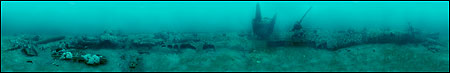
Rough single view photo-mosaic of U-85 created by Joe Hoyt on June 22, 2008.
Click here for a larger view.


 . The 2008 expedition was lead by the
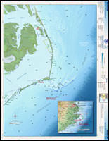