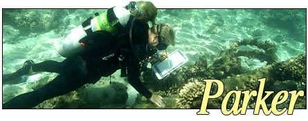
One July 23rd, 2006, the NOAA ship Hiialakai returned to Honolulu following a 28-day research cruise to the Northwestern Hawaiian Islands. The multidisciplinary expedition included six maritime archaeologists with NOAA's National Marine Sanctuary Program conducting non-invasive survey at Kure Atoll and Pearl and Hermes Atoll. The NOAA team included: Brenda Altmeier (Florida Keys NMS), Dr. Kelly Gleason (Pacific Islands Region NMS), Tane Casserley (Maritime Heritage Program NMS), Lindsey Thomas (Hollings program intern from the University of Georgia), Robert Schwemmer (West Coast Region NMS), and Dr. Hans Van Tilburg (Pacific Islands Region NMS, principal investigator). Surveying wreck sites in the vast Hawaiian archipelago reveals our seafaring history and provides a platform for the message of preservation and comprehensive ocean stewardship. The Parker is one of those opportunities.
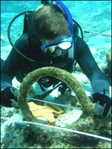 |
| NOAA archaeologist measuring rigging elements near the reference baseline. (Photo: NOAA NMSP) |
|
|
The New Bedford whaler Parker was lost on September 24th 1842 at Kure Atoll during a fierce storm. The seas crashed through the cabin windows at 2:00 AM, and immediately the vessel went onto the reef. The ship had struck on the north side of the atoll and became a complete wreck in under an hour, very few provisions (1 peck of beans, 15 pounds of salted meat) being hastily salvaged by the unlucky survivors. Cutaway masts and some of the floating spars were fashioned into a crude raft, for the lowered boats had been stove in by the seas. It took the exhausted men eight days to drift and warp this raft to the island on the southeastern side of the atoll. There, some of the ship remains of the wrecked British whaler Gledstanes (lost in 1837) provided firewood and building materials. The Gledstanes' dog, having gone wild during his years of isolation, provided some variety in the crew's diet of seabirds and seals, however brief.
The castaways spent a hard eight months fighting for survival on the low island at the atoll. 120 Laysan albatross took flight with inscribed wooden tallies fixed to their legs in an attempt to alert rescuers. More than 7,000 seabirds were killed for food and some 60 seals as well. What impact did this have on the species at the atoll? Fortunately for the original inhabitants, the Captain and a few others were finally picked up from Ocean (Green) Island on April 16, 1843 by the ship James Stewart. The rest of the crew remained on island until May 2, when they were rescued by the New Bedford whaler Nassau and taken to Honolulu.
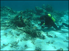 |
| The scattered remains of a whaling vessel lie among the coral patch reefs and sandy depressions of the lagoon. (Photo: NOAA NMSP) |
|
|
The physical remains of the ship fill in more details of the story. At Kure Atoll the maritime team completed a phase two in situ mapping survey of the shipwreck site designated MA-12. Anchors, anchor chain, hull sheathing, copper fasteners, hawse pipes, windlass, rigging hardware, wire rope, bricks, and other material are distributed in a line over 100 meters in length. These were meticulously drawn into a site plan, an accurate map of all the visible artifacts in their untouched state. The team also discovered a trail of bricks and broken try pot shards (cauldrons used to render the whale oil from the blubber) in a small pass through the reef crest. Yet survey outside the reef crest found almost no artifacts at all. It's possible that the extremely violent storm and seas brought the vessel entirely into the shallow back reef area, hundreds of meters from the reef pass, where she grounded at a heading of 135 degrees magnetic. Deck features like the tryworks and pots were washed over the side as the ship first entered the lagoon.
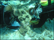 |
| NOAA archaeologists measuring some of the many small artifacts at the site. (Photo: NOAA NMSP) |
|
|
The lagoon site is relatively shallow, 8-18 feet of water. The bottom type is patch coral reef, coralline substrate, and rubble and sand areas. Coral cover is abundant, and great care was taken by all divers to avoid any and all inadvertent damage to living resources. But is this wreck site really the whaler Parker? The types of artifacts correspond to a mid-19th century whaler, and the site location is consistent with the historical report, but there is no conclusive piece of evidence as yet, so the identification as the Parker remains preliminary. Site survey work in 2005 involved the removal of a few diagnostic artifacts (with oversight by the appropriate management agencies). These were conserved at the Heritage Resources Conservation Lab, California State University, Chico. Artifact 2006-018 appears to be a section of early wire rope. Analysis (pending) of these and other clues may lead to a positive identification in the future.
The underwater survey of the Parker site provides images and data to be shared with the public. The survey also completes the in situ artifact inventory for the purposes of monitoring and management of this protected and rare resource. The Parker lies within State waters, also part of the Northwestern Hawaiian Island Marine National Monument.
 |
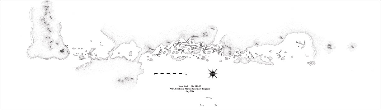
| The site plan of MA-12 at Kure Atoll. Click here for a larger image. (Photo: NOAA NMSP) |
|
|
The scattered and deteriorated whaler wreck rests quietly under the dappled waters of Kure lagoon, surrounded by reef fish and the colorful coral ecosystem. Nonetheless, the peaceful location serves as a window into a violent event and distant struggle for survival, stories which are a common theme in the historical component of the Northwestern Hawaiian Islands Marine National Monument.

Additional Resources and Links
Northwestern Hawaiian Islands Marine National Monument
To learn more about the expedition click here.
Hawaii Department of Land and Natural Resources
|


