State of Sanctuary Resources
This section provides summaries of the conditions and trends within four resource areas: water, habitat, living resources, and maritime archaeological resources. For each, sanctuary staff and selected outside experts considered a series of questions about each resource area. The set of questions is derived from the Office of National Marine Sanctuaries' mission, and a system-wide monitoring framework (NMSP 2004) developed to ensure the timely flow of data and information to those responsible for managing and protecting resources in the ocean and coastal zone, and to those that use, depend on, and study the ecosystems encompassed by the sanctuaries. The questions are meant to set the limits of judgments so that responses can be confined to certain reporting categories that will later be compared among all sanctuary sites and combined. The Appendix (Rating Scheme for System-Wide Monitoring Questions) clarifies the set of questions and presents statements that were used to judge the status and assign a corresponding color code on a scale from "good" to "poor." These statements are customized for each question. In addition, the following options are available for all questions: “N/A” –the question does not apply; and “undetermined” – resource status is undetermined. In addition, symbols are used to indicate trends: “ ▲” – conditions appear to be improving; “▬” – conditions do not appear to be changing; “ ▼” –conditions appear to be declining; and “?” – the trend is undetermined.
This section of the report provides answers to the set of questions. Answers are supported by specific examples of data, investigations, monitoring and observations, and the basis for judgment is provided in the text and summarized in the table for each resource area. Where published or additional information exists, the reader is provided with appropriate references and Web links.
Judging an ecosystem as having "integrity" implies the relative wholeness of ecosystem structure and function, along with the spatial and temporal variability inherent in these characteristics, as determined by the ecosystem's natural evolutionary history. Ecosystem integrity is reflected in the system's ability to produce and maintain adaptive biotic elements. Fluctuations of a system's natural characteristics, including abiotic drivers, biotic composition, complex relationships, and functional processes and redundancies are unaltered and are either likely to persist or be regained following natural disturbance.
Not all questions, however, use ecosystem integrity as a basis for judgment. One focuses on the impacts of water quality factors on human health. Another rates the status of key species compared with that expected in an unaltered ecosystem. One rates maritime archaeological resources based on their historical, archaeological, scientific and educational value. Another considers the level and persistence of localized threats posed by degrading archaeological resources. Finally, four ask specifically about the levels of ongoing human activity that could affect resource condition.
Thunder Bay National Marine Sanctuary regulations specify the management of cultural resources. Therefore, the sanctuary manages shipwrecks and related maritime archaeological resources, and not ecological resources. Consequently, this condition report does not directly address other aspects of the ecosystem. Specifically, Questions 5, 6, 7 and 8 relating to Habitat and Questions 9, 10, 12 and 13 relating to Living Resources were deemed not applicable due to the scope of sanctuary management regulations and therefore, responses to these questions have not been provided. Exceptions, however, occur when the natural resource-based questions can be addressed in the context of how that ecosystem element impacts maritime archaeological resources and the public's access to these resources. For this reason, Questions 1, 2, 3 and 4 relating to Water Quality are answered, as are Questions 11 and 14 relating to non-indigenous species. A text box provides a general overview of the condition and trends of ecological resources in the sanctuary, as determined by agencies other than the sanctuary.
Although its regulations specify the management of cultural resources, the Thunder Bay sanctuary promotes and facilitates a broad spectrum of natural resource research (see Response to Pressures section). From real-time weather observation and instrumentation to artificial reefs to the chemistry and microbiology of submerged sinkholes, the sanctuary's research efforts seek to better understand the natural aspects of northern Lake Huron. The sanctuary's role in this natural resource research is evolving and expanding. Consequently, future condition reports may seek to address natural resources as stand-alone questions.
In 2010, the Nature Conservancy (TNC) in Michigan released a report titled, "The Sweetwater Sea: Strategies for Conserving Lake Huron Biodiversity" (Franks Taylor et al. 2010). This report, developed through a two-year planning process involving more than 400 individuals from more than 100 agencies and organizations from around the Lake Huron basin, summarizes the condition and long-term outlook of Lake Huron. The report describes Lake Huron as an ecologically rich and globally significant ecosystem; however, its biodiversity is at risk. The most critical threats to Lake Huron's biodiversity were identified as non-native invasive aquatic and terrestrial species, climate change, rapid and poorly planned residential and industrial growth, altered shorelines and hydrology (e.g., dams and barriers), and agricultural, forestry and urban non-point source pollution.
Status ratings were assigned to seven key biodiversity features:
- Open water benthic and pelagic ecosystem (open water ecosystem beyond the 30-meter bathymetric contour from the mainland or islands, including reefs and shoals): FAIR
- Nearshore zone (submerged lands and water column of Lake Huron starting at zero meters in depth and extending to 30 meters in depth, not including areas upstream from river mouths and riverine coastal wetlands): FAIR
- Islands (land masses within Lake Huron that are surrounded by water, including artificial islands that are 'naturalized' or support nested targets. Nested feature examples: colonial nesting waterbirds, globally rare species, migratory bird stopover sites): GOOD
- Native migratory fish (native fish that migrate to and depend on tributaries, nearshore areas, or wetlands as part of their natural life cycles): FAIR
- Coastal wetlands (all types of wetlands with historic or current hydrologic connectivity to, and directly influenced by Lake Huron: FAIR
- Coastal Terrestrial System (natural communities from the line of wave action to two kilometers inland): FAIR
- Aerial Migrants (migrating species with high fidelity to Lake Huron, and for which migratory corridors and stopover habitat associated with the lake are crucial to their survival): FAIR
The ratings used by TNC were as follows:
- Very Good - the indicator is functioning at an ecologically desirable status and requires little human intervention.
- Good - the indicator is functioning within its acceptable range of variation; it may require some human intervention.
- Fair - the indicator lies outside its acceptable range of variation and requires human intervention. If unchecked, the target will be vulnerable to serious degradation.
- Poor - allowing the indicator to remain in this condition for an extended period will make restoration or preventing extirpation practically impossible.
A copy of the full report may be downloaded here.
Water
1. Are specific or multiple stressors, including changing oceanographic and atmospheric conditions, affecting water quality and how are they changing?
This question is rated "good/fair" because selected conditions may degrade maritime archaeological resources and reduce the public's access to these resources, but are not likely to cause substantial or persistent declines. The trend is "undetermined."
Water quality in Lake Huron has been strongly influenced by invasive zebra and quagga mussels. These mussels occur at high densities, filter large water volumes while feeding on suspended materials, and deposit particulate waste on the lake bottom. Because phosphorus is associated with suspended particulate matter, mussels located in shallow, nearshore areas are believed to sequester phosphorus from tributaries before it can be transported offshore. Phosphorus is the limiting nutrient for primary production; therefore, nearshore areas are experiencing enhanced eutrophication and its effects, including deposits of filamentous benthic algae on beaches and algal blooms, which in turn can limit public access to sanctuary resources. In contrast, however, offshore areas are experiencing starvation symptoms such as pronounced declines of zooplankton and benthic invertebrate communities and a collapse of the demersal fish community. This assessment applies generally to Lake Huron, but is applicable to Thunder Bay. Although eutrophication does not directly impact shipwrecks, the presence of invasive mussels does (see Question 11 for additional explanation regarding the impact of invasive mussels on sanctuary resources).
Changing atmospheric conditions can potentially impact sanctuary resources, though the range and significance of these changes has not been well studied. Several potential direct connections likely exist. For example, in Lake Huron there has been an average yearly decline in ice cover of 1.64%, resulting in a 62% total ice loss over the last 38 years (Wang et al. 2011). However, researchers have also noted that decreased ice coverage enhanced evaporation and led to a significant water level decline of as much as three to four feet (varies by lake) from the early 1990s to the early 2000s (Sellinger et al. 2008). Decreasing water levels present a range of potential negative impacts to sanctuary resources, including exposing sites that were previously submerged.
Research is needed to better understand the extent to which changing atmospheric conditions, including climate change, could impact sanctuary resources. Similarly, atmospheric conditions that trigger changes in Lake Huron's water quality may indirectly affect sanctuary resources by impacting public visitation and archaeological research at shipwreck sites.
2. What is the eutrophic condition of sanctuary waters and how is it changing?
This question is rated "fair" because selected conditions may cause measurable but not severe declines in maritime archaeological resources and possibly the public's access to these resources, as well. However, eutrophication from the Thunder Bay watershed is currently low and not growing appreciably because human population growth in the area is near zero and there are recent changes in laws governing land application of phosphorus. Additionally, reservoirs trap nutrients coming down the Thunder Bay River and the watershed still is largely forested or in pasture, and dreissenid effects appear to be declining. Therefore the trend is "not changing." However, given the poor eutrophic conditions in other areas of the Great Lakes and the dynamic nature of Thunder Bay, the potential effects of change in condition are summarized briefly below.
Eutrophication resulting from excessive nutrient loads generally promotes excessive algae growth (harmful algal blooms) and decay, thus causing a disruption in the normal function of the ecosystem. Water quality can be severely reduced and will usually become cloudy and discolored, thus potentially impacting sanctuary resources and the public's access to them (e.g., reduced visibility; algal blooms can result in beach closures). In the Great Lakes, eutrophication is often associated with green algae (Cladophora) and blue-green algae (cyanobacteria) blooms that are capable of drastically altering benthic conditions. These algal blooms are likely due to multiple factors, including inadequate municipal wastewater and residential septic systems; runoff from increased impervious surface areas and agricultural row-crop areas; discharges from tile drainage, which result in more dissolved reactive phosphorus loading; industrial livestock operations; ecosystem changes from invasive mussel species; and impacts from climate change, which include warmer water and more frequent and intense precipitation and stormwater events (International Joint Commission 2011).
In the past five to 10 years, excessive Cladophora growth in parts of the Great Lakes has re-emerged as a management problem. A 2004 workshop held at the Great Lakes WATER Institute at the University of Wisconsin-Milwaukee noted that "[Cladophora] has resulted in public complaint, generally related to the decline in aesthetic conditions near the lakeshore. Other negative impacts include human health hazards (e.g., Cladophora mats may promote the growth or retention of pathogens), the clogging of water intakes (including those of power plants), the loss of recreation opportunities, and declining lakefront property values. In addition to direct impacts on humans, excessive Cladophora growth may have significant impacts on ecosystem functions and properties such as nutrient cycling, energy flow and food web structure" (Bootsma et al. 2004). Although algal blooms do not directly impact sanctuary resources, algal blooms that lead to beach closures and reduced water clarity could negatively impact the public's access to shipwrecks. Although eutrophication from the watershed appears to be less in the Thunder Bay area than at many other locations in the Great Lakes, Cladophora is indeed a problem, and nearshore shunt of nutrients is thought to be the leading cause (Hecky et. al. 2004).
3. Do sanctuary waters pose risks to human health and how are they changing?
This question is rated as "good/fair" because selected conditions that have the potential to affect human health, and thereby impact the public's access to sanctuary resources, may exist, but human impacts have not been reported. The trend is "not changing."
Escherichia coli (E. coli) is often used as an indicator organism in nearshore water quality monitoring, and its presence can indicate that the water may be contaminated and health impacts such as fever, flu-like symptoms, ear infection, respiratory illness, rashes, gastroenteritis, cryptosporidiosis and hepatitis can occur. As such, county health departments in Michigan regularly monitor levels of E. coli in waters adjacent to public beaches and compare levels against state water quality standards. When E. coli levels exceed guidelines set by the state, swimming advisories are issued and beaches are closed for swimming. Beaches are only reopened when E. coli levels fall within acceptable levels again.
The Michigan Department of Natural Resources and Environment's "BeachGuard"database includes 14 beaches in Alpena County. Two of the Lake Huron beaches in the city of Alpena had closures in 2009 and 2010, and one had a closure in 2011 (http://www.deq.state.mi.us/beach/BeachDetail.aspx?BeachID=285):
Blair Street
- 2009: One day of closure (8/18-19, 2009) for high bacteria levels due to stormwater runoff.
- 2010: Three days of closure (8/18-19, 2010) for high bacteria levels due to stormwater runoff and 8/10-12/10 for rainfall due to stormwater runoff.
Starlite Beach
- 2010: Two days of closure (8/10-12, 2010) for high bacteria levels due to stormwater runoff
Michekewis Beach
- 2011: One day of closure (6/23-24, 2011) for high bacteria levels due to stormwater runoff
Harmful algal blooms (HABs) are becoming an increasing problem in the Great Lakes. While HABs are more prevalent in Lake Michigan and Lake Erie, there are incidents of HABs on the Thunder Bay shoreline. HABs can cause fishkills that can wash up on shore and produce harmful conditions to marine life as well as humans. In addition, blue-green algae (cyanobacteria) can produce skin irritants under certain conditions, and some can produce multiple types of harmful toxins. These issues could potentially limit recreational access to sanctuary resources.
4. What are the levels of human activities that may influence water quality and how are they changing?
This question is rated as "good/fair" because some potentially harmful activities exist, but they do not appear to have had a negative effect on water quality, thus there is minimal impact to public access of sanctuary maritime archaeological resources. The trend is "improving."
Human activities that may influence water quality include both point and nonpoint source pollution. The Thunder Bay River watershed has relatively few point source pollutant sources. Few factories and wastewater treatment plants are in the watershed, with only six permitted discharges in the basin. Recent surveys by the Michigan Department of Environmental Quality (MDEQ) indicate that most of the Thunder Bay watershed is meeting state water quality standards.
As mentioned previously, poor water quality has the potential to limit recreational use of sanctuary resources. At this time, however, the human activities that influence water quality do not appear to have had a negative effect on water quality.
Water Quality Status and Trends
Status: Good Good/Fair Fair Fair/Poor Poor Undet.
Trends:
▲ Conditions appear to be improving.
5. What is the abundance and distribution of major habitat types and how is it changing? Thunder Bay National Marine Sanctuary regulations specify the management of only maritime archaeological resources. For this reason, this question was deemed "not applicable." 6. What is the condition of biologically structured habitats and how is it changing? Thunder Bay National Marine Sanctuary regulations specify the management of only maritime archaeological resources. For this reason, this question was deemed "not applicable." 7. What are the contaminant concentrations in sanctuary habitats and how are they changing? Thunder Bay National Marine Sanctuary regulations specify the management of only maritime archaeological resources. For this reason, this question was deemed "not applicable." 8. What are the levels of human activities that may influence habitat quality and how are they changing? Thunder Bay National Marine Sanctuary regulations specify the management of only maritime archaeological resources. For this reason, this question was deemed "not applicable." Habitat Status and Trends Status: Good Good/Fair Fair Fair/Poor Poor Undet. Trends:
▲ Conditions appear to be improving.
9. What is the status of biodiversity and how is it changing? Thunder Bay National Marine Sanctuary regulations specify the management of only maritime archaeological resources. For this reason, this question was deemed "not applicable." 10. What is the status of environmentally sustainable fishing and how is it changing? Thunder Bay National Marine Sanctuary regulations specify the management of only maritime archaeological resources. For this reason, this question was deemed "not applicable." 11. What is the status of non-indigenous species and how is it changing? Non-indigenous species in the sanctuary, particularly zebra and quagga mussels, have caused or are likely to cause declines in the integrity of maritime archaeological resources. For this reason, the response to this question is rated "poor." The rate that mussels may be impacting resources is very slow and not comprehensively documented in the sanctuary, but the impact is negative and irreversible. Due to uncertainty regarding future changes in non-indigenous species dynamics and their impacts on sanctuary resources, the trend is "undetermined." Zebra and quagga mussels (dreissenids) are highly concentrated near the mouth of the Thunder Bay River, which enters Thunder Bay at the city of Alpena (Black et al. 2000). Because zebra and quagga mussels have an affinity for hard substrates, they are commonly found attached to submerged maritime archaeological resources. When first introduced into the Great Lakes in the 1980s, zebra and quagga mussels first colonized shallow, well-lit shipwreck sites. Today, however, sanctuary archaeologists have observed significant quagga mussel infestation on shipwrecks sites as deep as 300 feet (R. Green, TBNMS, pers. obs.). Although dreissenids settle on all hard substrates, it has been documented that they appear to prefer wrought iron and steel surfaces (Watzin et al. 2001). As a result, there is concern over the effects of the spread of dreissenid colonization on shipwrecks. The latest lake-wide survey of quagga mussels, which included sites within the sanctuary, showed that mussel abundances increased two-fold between 2003 and 2007 at depths greater than 50 meters, and about four-fold at depths between 51 and 90 meters (T. Nalepa, NOAA GLERL, unpub. data). The initial impact of dreissenid attachment is the loss of "archaeological visibility" - the surfaces of a historic shipwreck can literally disappear under layers of mussels (Kraft 1996, Watzin et al. 2001). While the shape of the shipwreck is still recognizable, the details of its surface and construction are obscured, thus severely impacting the potential for detailed study of these resources (Figures 45 and 46). Infestation of dreissenids could also diminish the interest in diving on these wrecks, resulting in an economic impact in the area through loss of tourism (Black et al. 2000). The weight of these mussels can also affect the structural integrity of the wrecks, causing portions to break off or collapse. Also, removing dreissnid mussels from the surfaces of these resources could result in further damage and loss (Watzin et al. 2001). A dramatic example of this is the wooden nameboard on the stern quarter of the schooner Kyle Spangler (see Figures 27 and 28 in Pressures section). In addition, when mussels colonize steel structures such as walls, pipes, and iron fasteners and fittings on shipwrecks, the iron and steel corrodes at a significantly accelerated rate as compared to ferrous material not encrusted with mussels (Watzin et al. 2001). As dreissenid colonies grow, a thick layer of organic matter accumulates under a mat of living and dead shell material, and a complex community of bacteria becomes established. These microorganisms are likely facilitating the corrosion process because they are capable of lowering pH levels on substrate surfaces, thus greatly increasing rates of corrosion (Little et al. 2000,Watzin et al. 2001). Since many of the wooden ships in the Thunder Bay sanctuary are primarily iron and steel fastened, the structural integrity of these resources could potentially be compromised (Watzin et al. 2001). In some locations, mussels have also been shown to contribute to the concentration of toxic metals on and in the proximity of shipwrecks. A study by LaValle et al. (1999) showed that as a consequence of utilizing shipwrecks as suitable attachment substrates, the wastes from the mussels necessarily accumulate on the shipwrecks. 12. What is the status of key species and how is it changing? Thunder Bay National Marine Sanctuary regulations specify the management of only maritime archaeological resources. For this reason, this question was deemed "not applicable." 13. What is the condition or health of key species and how is it changing? Thunder Bay National Marine Sanctuary regulations specify the management of only maritime archaeological resources. For this reason, this question was deemed "not applicable." 14. What are the levels of human activities that may influence living resource quality and how are they changing? As was described in Question 11, the introduction of zebra and quagga mussels (dreissenids) in the Great Lakes has caused declines in maritime archaeological resource quality. However, the cause of this introduction (transoceanic shipping and ballast water exchange in the late 1980s) is now regulated; these regulations are in place to prevent or minimize new introductions. Therefore, although some potentially harmful activities exist that could pose a concern for invasions of new species, they do not appear to currently have a negative effect on maritime archaeological resources. For this reason, this question is rated as "good/fair" with a "not changing" trend. The dispersal of dreissenid mussels is mediated by both natural (currents, birds and other animals) and human-related mechanisms (Carlton 1993). Human mechanisms include those related to waterways, vessels, navigation and fishery activities, and a wide variety of miscellaneous vectors (e.g., intentional movements, aquarium releases, and scientific research). The various life stages of mussels (larvae, juveniles and adults) can be transported by one or more of the following mechanisms: currents, animals, canals, ballast water, other vessel water, fish stocking, bait bucket, fire truck water, aquarium releases, amphibious planes and scientific research. Ballast water in transoceanic vessels was the initial cause of mussel introduction from Europe to the Great Lakes.
Living Resources Status and Trends Status: Good Good/Fair Fair Fair/Poor Poor Undet. Trends:
▲ Conditions appear to be improving.
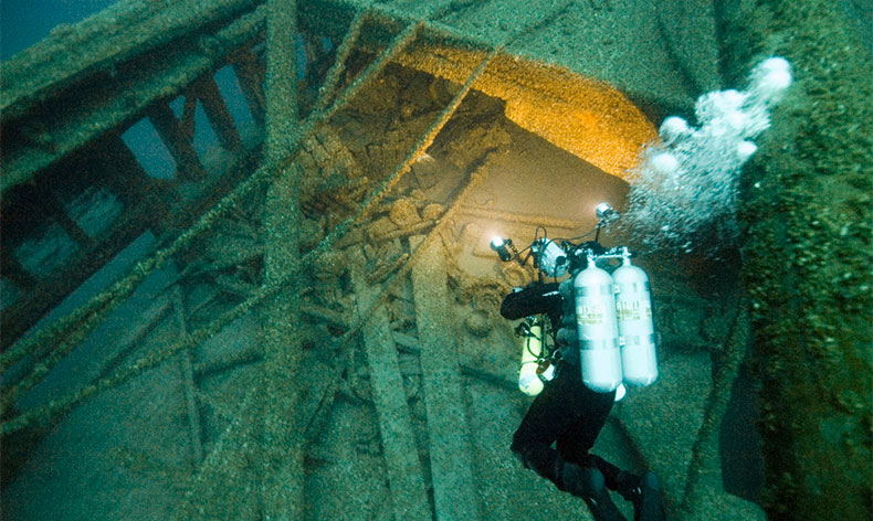
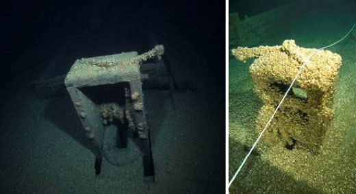
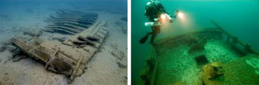
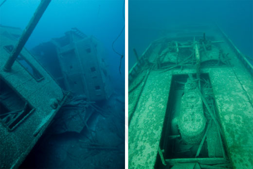
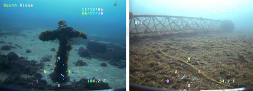
15. What is the integrity of known maritime archaeological resources and how is it changing? As with any question regarding archaeology, context plays an important role in determining the answer. As indicated previously, Lake Huron's cold, fresh water ensures that Thunder Bay's shipwrecks are among the best preserved in the world, some nearly completely intact with a high degree of physical integrity. For the purposes of this report, however, the archaeological integrity of Thunder Bay's resources has been assessed irrespective of their preservation versus shipwrecks located in other environments around the world; instead, the resources have been evaluated within the context of the Great Lakes environment. It is important to note, however, that although the state of preservation and archaeological integrity are often closely tied, a site does not have to be "intact" to be considered archaeologically significant (Figures 47 and 48). For example, the scattered but well-preserved timbers of the 1844 paddlewheel steamer New Orleans possess high archaeological value because few examples of such craft exist. The response to this question is rated "good/fair" because selected archaeological resources exhibit indications of disturbance or change, but there appears to have been little or no reduction in historical, archaeological or educational value. The presence of mussels (see Question 11) is the primary reason for a "good/fair" rather than a "good" rating. Here again, context plays an important role. The presence of invasive mussels on nearly all sanctuary sites currently makes detailed data retrieval difficult - although the information still exists, it is beneath a layer of invasive mussels. As described in Question 11, it is possible that mussels are causing permanent damage, though the scale of the damage and the time over which it is occurring is not presently known. Additionally, although future negative human impacts can be lessened (and indeed, some have been; see Responsesection), the slow, natural deterioration of sanctuary resources is inevitable, though generally occurring on a timescale that is generations long rather than months or years. For this reason, the trend is considered "declining," although this too must be taken within context. Of the 45 known shipwreck sites in the sanctuary's current 448-square-mile boundary, sanctuary staff and partners have conducted field assessments at 44 sites. Of the 47 known wrecks in the proposed expansion area, the sanctuary has conducted field assessments at 32 sites. Conducted using various methods and data, including diver observations, sonar images, physical measurements, hand drawn maps, and video and still imagery acquired by divers and remotely operate vehicles, these assessments form the basis for judging the integrity of Thunder Bay's maritime archaeological resources. The reader is directed to the Site History,Pressures, and Response to Pressures sections for representative visuals of sanctuary shipwreck sites and data products. Several factors influence a shipwreck's integrity from the moment of its sinking to the present, with some factors playing more significant roles than others. Shipwreck sites addressed in this report occur in a range of locations and environments (i.e. nearshore vs. offshore, consistently cold vs. seasonally changing water temperatures, sand vs. hard bottom, etc.) and depths (0-300 feet), and represent a wide range of ship types and casualty causes. These factors and more play a role in the "site formation process," which is essentially the cumulative effect of forces at play on a shipwreck site from its sinking to the present. In and around the sanctuary, there is substantial variation in the way archaeological sites have formed, each presenting researchers with unique opportunities. For example, as mentioned previously, depth has a considerable impact on a site's formation. Deeper shipwrecks are generally more intact than shallower sites and have greater potential for smaller artifacts to survive in context. Conversely, shallower sites located in more dynamic environments will become broken up more easily, but may more readily reveal internal construction and design attributes difficult or impossible to document in fully intact shipwrecks. Though the sites look physically much different, each retains archaeological integrity. Notably, the resources addressed in this report break down into well-balanced depth categories: 45 sites are located at depths of 0-30 feet; 23 sites are located at depths of 31-130 feet; 18 sites are located at depths of 131-200 feet; and six sites are located at depths greater than 200 feet. Coupled with the historical significance of the vessels, the result is an impressive and comprehensive archaeological record. In some cases, similar ship types may be studied via the dual lenses of different archaeological site formation processes. For example, the sister ships Norman andGrecian, both 300-foot-long steel bulk freighters built in 1890 and 1891, respectively, provide unique opportunities to study historically significant ship architecture. Resting in 200 feet of water, the mostly intact Norman retains many features not present at the shallower Grecian site, which rests in just 100 feet of water (Figures 49 and 50). Conversely, the Grecian's many exposed construction features allow for detailed study, and its shallower depth affords divers more time to work. Other steamers and schooners located in and around the sanctuary, though not sister ships, exist at similar complementary depths. Finally, and most powerfully, the archaeological integrity of individual sanctuary resources is strengthened tremendously by the fact that, collectively, Thunder Bay's shipwrecks present a microcosm of Great Lakes commercial shipping and culture. The area's shipwrecks reflect transitions in ship architecture and construction methods, from wooden sailboats to steel-hulled vessels, and represent virtually all types of vessels used on the open Great Lakes. These vessels were engaged in nearly every type of trade, thereby linking Thunder Bay inextricably to Great Lakes commerce. Encompassing an extensive array of historical themes, backed by an impressive archaeological record, Thunder Bay's collection of shipwrecks presents a broad history of Great Lakes culture. 16. Do known maritime archaeological resources pose an environmental hazard and is this threat changing? Known maritime archaeological resources within the sanctuary pose no environmental threats. One known shipwreck outside the sanctuary's eastern boundary may still contain fuel oil, but there have been no reported fuel leaks since the vessel's sinking in 1959. Therefore, this question is rated "good" with a "stable" trend. The shipwreck within the sanctuary that historically represented the greatest environmental hazard is the German freighter Nordmeer, given the large quantity of fuel oil onboard when the vessel grounded just north of Thunder Bay in 1966. The removal of fuel oil is well documented and was carried out within the first five years of the vessel's sinking. A number of contractors and government agencies coordinated the removal of the vessel's fuel oil. On July 16, 1971, Michigan State Rep. Joseph P. Swallow announced that officials of the U.S. Environmental Protection Agency, in conjunction with the U.S. Coast Guard and Michigan Department of Natural Resources, made a final inspection of the sunken freighter and determined that the vessel was free of oil (The Alpena News, 1971). Because small amounts of oil were still trapped in the inaccessible piping system and bulkheads of the Nordmeer, it was postulated that an iridescent sheen of oil would continue to be visible on the surface of the water around the vessel when certain weather conditions prevail. In 2010, a small amount of residual oil was discovered at the Nordmeer site, creating a light sheen on the water's surface. The U.S. Coast Guard Alpena Station and the sanctuary responded in a well-coordinated effort, highlighting the good working relationship between these two agencies. The oil discovered in 2010 was determined to be residual oil located in the vessel's piping, allowed to leak to the surface when a mating flange between two pipes broke and water temperatures warmed sufficiently to make the oil less viscous. The pipe has since been capped off and no sheen has reappeared at the site. Just outside the sanctuary's eastern boundary is the wreck of the Liberian-flagged freighter Monrovia. Built in 1943 in Scotland, the vessel was converted from coal to oil fuel in 1950 (Lloyd's Register of Shipping, 1950). The victim of a collision with the Canadian steamer Royalton, Monrovia sank in 1959 with no loss of life. The quantity of fuel oil onboard at the time of the vessel's sinking is not presently known, but one informal estimate made by the U.S. Coast Guard's 9th District well after the sinking, and reported in The Alpena News, suggested that less than 50,000 gallons would have been onboard at the time of Monrovia's sinking. The sanctuary is currently conducting historical research and contacting divers and salvagers who have worked on the site (the wreck's steel cargo was salvaged) in an effort to determine if any fuel oil remains. Retired local salvager Robert Massey has related to the sanctuary that his company did not remove any fuel oil because the water was too cold and the oil too viscous (R. Massey, pers. comm., 2012). To date, the sanctuary is not aware of any current or historic reports of fuel leaking from the wreck site. Should the question remain unresolved through historical research, the sanctuary will work with appropriate partners to investigate the wreck of Monrovia and determine its potential as an environmental hazard. Additional 20th-century shipwrecks occur in and around the sanctuary, including Viator (1904-1935), D. R. Hanna (1906-1919), W. H. Gilbert (1892-1914), W. C. Franz (1901-1934), Etruria (1902-1905) and Isaac M. Scott (1909-1913). The sanctuary has determined that none of these shipwrecks carried fuel oil. Notably, should sanctuary expansion occur, the proposed boundaries would include a 1,300 square-mile area that has potential for unexploded ordnance and military-related debris within it. NOAA's Lake Huron chart 14860 contains a note cautioning mariners against "anchoring, dredging, or trawling in the area due to the possible existence of unexploded ordnance." As demonstrated by recent University of Michigan (U of M) research, the potential for prehistoric archaeological sites exists in this area. The sanctuary partnered with U of M in 2010 to map the area with multibeam sonar and again in 2011 to ground truth promising targets with divers. Given the potential for both prehistoric and historic archaeological resources, as well as the area's significance as a fish habitat, the sanctuary is interested in facilitating a fuller cultural and natural assessment of the area. The sanctuary is currently working with the Michigan Department of Environmental Quality (MDEQ) Superfund Section to identify stakeholders with an interest in assessing the area. MDEQ has requested assistance from the U.S. Army Corps of Engineers to evaluate the known munitions in the area (Figures 51 and 52) and potentially address their findings via the Military Munitions Response Program. 17. What are the levels of human activities that may influence maritime resource quality and how are they changing? The various human activities identified in the "Pressures on Sanctuary Resources" section of this report can have measurable impacts to maritime archaeological resources, but evidence suggests effects are localized, not widespread. For this reason, this question is rated as "fair" with an "improving" trend. Visiting dive boats and divers have the greatest potential to influence the quality of maritime archaeological resources. This includes anchor damage to sites, leaving temporary mooring lines attached to sites where the lines later become derelict, poor diving practices by divers (e.g., brushing mussels off delicate wood surfaces or handling and moving artifacts), and souvenir hunting and looting. The sanctuary's shipwreck mooring program, education and outreach efforts, and enforcement efforts in partnership with the U.S. Coast Guard mitigate some of these pressures at selected sites. However, the prevalence and degree of these kinds of disturbances at all sites in and around the sanctuary is not known. Consistently monitoring sites particularly susceptible to diver impacts is an important first step, but this evidence must be correlated with overall diving activity in the sanctuary to be truly meaningful. Currently, the sanctuary does not have a precise accounting of diving activity in and around the sanctuary, although it maintains good relationships with area dive charter businesses. Informal data suggests that there is a significant demand for scuba diving charter services in the Thunder Bay area, with two of the most established dive charter businesses reporting nearly full capacity over the last two years. Currently, four dive charter businesses are located in Alpena and Rogers City. Several southern Michigan and out-of-state charters also visit sanctuary resources. Additionally, there are private vessels that visit sanctuary resources. At present, it is unknown if there are more or fewer dive boats and divers visiting the sanctuary in comparison to previous years. Per the sanctuary's 2009 Final Management Plan, the sanctuary is developing a mechanism whereby dive charters and private vessels visiting the sanctuary can voluntarily submit diving statistics. The sanctuary is currently (2012) working with the University of Michigan's Economic Development Administration University Center to study the broader economic and cultural impacts of the sanctuary on the region. Included in this study is a mechanism to measure the number of divers and dive charters visiting the sanctuary.
Maritime Archaeological Resources Status and Trends Status: Good Good/Fair Fair Fair/Poor Poor Undet. Trends:
▲ Conditions appear to be improving.
- Conditions do not appear to be changing.
▼ Conditions appear to be declining.
? Undeterminted trend.
N/A Question not applicable.
#
Status
Rating
Basis For Judgement
Description of Findings
1.
Stressors
Invasive zebra and quagga mussels have altered water quality; ice coverage has declined and water levels have fluctuated. Changes in water quality could negatively impact public access to sanctuary resources.
Selected conditions may degrade maritime archaeological resources, but are not likely to cause substantial or persistent declines.
2.
Eutrophic Condition

Algal blooms that lead to beach closures and reduced water quality could negatively impact the public's access to sanctuary resources.
Selected conditions may cause measurable but not severe declines in maritime archaeological resources.
3.
Human Health
Documented swimming advisories and beach closures may limit the public's access to sanctuary resources.
Selected conditions that have the potential to affect human health may exist but human impacts have not been reported.
4.
Human Activities
![]()
Few point sources, however, nonpoint source pollution can occur after heavy rain. Poor water quality could limit the public's access to sanctuary resources.
Some potentially harmful activities exist, but they do not appear to have had a negative effect on water quality.
Habitat
- Conditions do not appear to be changing.
▼ Conditions appear to be declining.
? Undeterminted trend.
N/A Question not applicable.
#
Status
Rating
Basis For Judgement
Description of Findings
5.
Abundance/ Distribution
Thunder Bay National Marine Sanctuary regulations specify the management of only maritime archaeological resources. For this reason, Questions 5 - 8 were deemed "not applicable."
N/A
6.
Structure
N/A
7.
Contaminants
N/A
8.
Human Activities
N/A
Living Resrouces
- Conditions do not appear to be changing.
▼ Conditions appear to be declining.
? Undeterminted trend.
N/A Question not applicable.
#
Status
Rating
Basis For Judgement
Description of Findings
9.
Biodiversity
Thunder Bay National Marine Sanctuary regulations specify the management of only maritime archaeological resources. For this reason, Questions 9 & 10 were deemed "not applicable."
N/A
10.
Extracted Species
N/A
11.
Non-indigenous Species
Zebra and quagga mussel colonization is causing archaeological resources to deteriorate and hinders the ability to accurately and precisely conduct archaeological documentation.
Non-indigenous species have caused or are likely to cause severe declines in maritime archaeological resources.
12.
Key Species
Thunder Bay National Marine Sanctuary regulations specify the management of only maritime archaeological resources. For this reason, Questions 12 & 13 were deemed "not applicable."
N/A
13.
Health of Key Species
N/A
14.
Human Activities
The original vector for invasion is not likely to affect the future fate of existing mussels, but could introduce other non-indigenous species.
Some potentially harmful activities exist, but they do not appear to have had a negative effect on maritime archaeological resources.
Maritime Archaeological Resources
- Conditions do not appear to be changing.
▼ Conditions appear to be declining.
? Undeterminted trend.
N/A Question not applicable.
#
Status
Rating
Basis For Judgement
Description of Findings
15.
Integrity
![]()
Mussel colonization and natural deterioration will persist, but resulting declines in integrity are slow. Management actions have slowed diver and boating impacts.
Selected archaeological resources exhibit indications of disturbance, but there appears to have been little or no reduction in historical, scientific, or educational value.
16.
Threat to Environment
Few, if any, wrecks pose an environmental threat, and those that do are localized.
Known maritime archaeological resources pose few or no environmental threats.
17.
Human Activities
![]()
All human activities are on the decline due to management actions (e.g., mooring, education, and enforcement activities).
Selected activities have resulted in measurable impacts to maritime archaeological resources, but evidence suggests effects are localized, not widespread.