Error processing SSI file
2010 Expedition Results
The expedition was led by David L. Gallo, special projects director for Woods Hole, and Christopher J. Davino, the president of RMS Titanic, Inc.
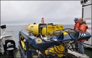
Mark Dennett of Woods Hole and Mike Dessner from the Waitt
Institute prepare to launch an AUV. (Photo: Robert Sitrick/WaittInstitute, 2010) |
This work began in late 2010 after the initial processing of terabytes of data collected by the REMUS 6000 Autonomous Underwater Vehicles (AUVs) "Ginger" and "Mary Ann" of the Waitt Institute and the REMORA Remotely Operated Vehicle (ROV) of Phoenix International and its camera and lighting systems from the Advanced Imaging and Visualization Laboratory (AIVL) of Woods Hole Oceanographic Institution (WHOI). The data resulted in a sonar map at various degrees of resolution (and hence detail) that narrowed the survey areas from the maximum extent of scattered artifacts and wreckage to close-up views of specific clusters of "features" (which could be artifacts ranging from pieces of the hull, superstructure or machinery of Titanic). Processing of the data continues in 2012.
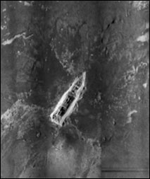
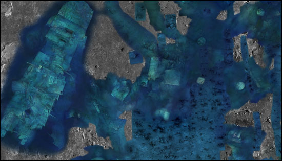
The sonar map of the bow section of the Titanic wreck site, showing seabed features and impact marks. (RMS Titanic, Inc./Woods Hole Oceanographic Institution AIVL) |
Together, they began the "tagging" of features as well as plotting changes in the seabed that included mud disturbed by the impact of sections of the hull striking bottom, scattered silt "blasted" by impact, and the mud plowed up by the striking and sliding of Titanic's bow on the ocean floor. The team also plotted scatters of coal and ceramics (dishes such as plates, cups and saucers) that as lighter objects had been distributed in distinct patterns on the sea floor by ocean currents as Titanic sank.
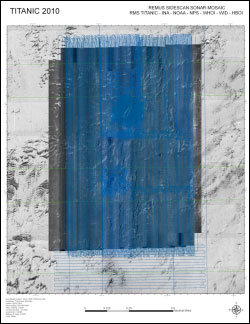
REMUS Sidescan Sonar coverage of the Titanic site. Click here for a larger image. (RMS Titanic, Inc./Woods Hole Oceanographic Institution AIVL) |
The GIS was then systematically added to with overlays of detailed photo-mosaics gathered by the ROV of the major hull sections as well as a number of the features. Among the features shown on the map are the hatch for cargo hold #1, which lies forward of the bow, boilers, the remains of the domed skylight from the aft grand staircase, a group of lifeboat davits, and sections of the hull which have been identified by the team and consulting Titanic historian Bill Sauder. Mr. Sauder's expertise in particular has been helpful thanks to his encyclopedic knowledge and thoroughness in documentation. This work continues - as one would expect with an immense number of artifacts lying on the sea floor.
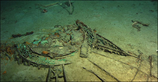 | | The aft grand staircase dome, as imaged in 2004. Click here for a larger version and more.
(Institute for Exploration/Center for Ocean Exploration at the University of Rhode Island/NOAA office of Exploration and Research)
|
The photo-mosaics created by William Lange's team at the AIVL offer a never-before seen perspective on the entire site and in particular the massive remains of the ship's detached bow and stern sections. While imaged previously, including down-looking mosaics of the bow in 1986 and 2004, the new images are in full color, and include profiles (the sides) of the bow as well as the gaping wound that represents where Titanic's bow tore free of the stern as it sank. Another new aspect of the 2010 work was the complete photo-mosaic documentation of Titanic's battered stern section, including a profile view and a dramatic mosaic of the stern, the last part of the ship to leave the surface.
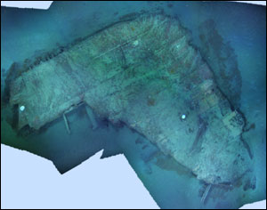
 | | A partially completed mosaic merging sonar and visual imaging data of the area around the stern. Click here for a larger version and more. (RMS Titanic, Inc./Woods Hole Oceanographic Institution AIVL)
|
What the GIS map does, with the addition of these dramatic, high-resolution images, is convey a full sense of not only the extent but the nature of the Titanic wreck site. It is a disaster scene, not unlike the site of an airplane crash, and due to its location in the deep sea, in many ways this is an accident scene that remains fresh and dramatic a century after it happened. Scattered in distinct patterns among the larger pieces of hull and machinery are thousands of artifacts that came from the inside the ship and from the people on board. They include dishes, fittings from cabins such as sinks and doorknobs, leaded glass windows, bottles of wine, silverware, cooking pots and pans, suitcases and bags, shoes, and other traces that show where victims came to rest amongst the wreckage. While no distinct human remains were observed, there were a number of places where it was obvious that someone had come to rest, as represented by articulated pairs of shoes, still laced or tied, and in one case, as observed in 2004, a crumpled large coat with a protruding boot, a clearly identifiable and heart-catching reminder of the tragedy of April 15, 1912.
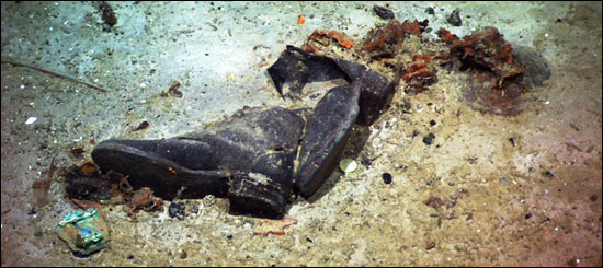 | | Shoes on the seabed at the Titanic site, 2004. (Institute for Exploration/Center for Ocean Exploration at the University of Rhode Island/NOAA office of Exploration and Research)
|
The significance of the GIS is more than a detailed graphic representation of the wreck site. It is a tool that allows the team to measure, plot and record the location of each feature and artifact and place them in "the real world" as represented by the GPS coordinates for the site and its major features. Through the plotting of each feature, patterns of distribution, showing how each piece fell to the sea bed, allows the team to reconstruct the sinking and break-up of Titanic, something archaeologists call the "site formation process." In addition to adding to the forensic study of the ship's destruction led by James Cameron and others, this also led the team to one of the most striking observations of the 2010 expedition.
A visual photo-mosaic of a piece of Titanic's hull. (RMS Titanic, Inc./Woods Hole Oceanographic Institution AIVL) |
When Titanic broke apart and sank, as has been known since its discovery, the bow and stern tore apart and sank separately. Subsequent expeditions located two large sections of the bottom of the hull, with the ship's keel (backbone). An approximately 70-foot section of Titanic - called at the time "the missing piece" -- is the source of the scattered remains of the hull and machinery that lay in that area - a section that included the galleys, pantries, wine stores, silverware locker, a handful of cabins, the ship's hospital and coal bunkers, the verandah cafe, and a portion of the first class dining room, to name a few of the compartments that were in that now disintegrated section of Titanic. The mapping of the wreck site not only shows where each piece was from and where it fell but also shows that this section of the ship - less than 10 percent of it - is the source for almost everything that lies scattered on the site. Other than a few items from the decks - the funnels, benches, the remains of the bridge - only a small portion of Titanic came tumbling out of the ship as it sank. What that means, in simple terms, is that Titanic's bow and stern remain largely intact, albeit "cracked" time capsules. This is also made apparent by the discoveries of James Cameron inside the bow, where intact paneling, furniture and other fittings makes Titanic an aptly named ghost town in the abyss.
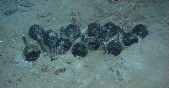 | | Bottles resting on the seabed outline a now disintegrated wooden crate that held them, 2004. Click here for a larger version and more. (Institute for Exploration/Center for Ocean Exploration at the University of Rhode Island/NOAA office of Exploration and Research)
|
The mapping of the site and the exceptional two and three-dimensional images of Titanic created by the AIVL set a new standard for deep-water archaeology and the documentation of underwater sites.
The GIS will serve not only as a scientific tool, but also provides the means for ongoing monitoring changes to the site, an invaluable resource for managing and protecting this internationally significant maritime memorial and historical archaeological site.
Links
Scanning Titanic for the future - E & T Magazine
Interactive: The Crash Scene - National Geographic
The Bow From Above - National Geographic
The Bow: Starboard Profile - National Geographic
The Stern From Above - National Geographic
The Stern: Starboard Profile - National Geographic
|