|
Researchers Shed New Light on Gulf of Mexico 'Flower Garden'
by Walter Bonora
National Marine Sanctuaries
Shelley DuPuy
Flower Garden Banks National Marine Sanctuary
Most of the reefs and banks scattered throughout the northwestern Gulf of Mexico have some degree of protection from human impacts. None of them, however, enjoy the level of protection that national marine sanctuary status confers on the Flower Garden and Stetson Banks, located approximately 100 miles off the Texas-Louisiana coast.
 |
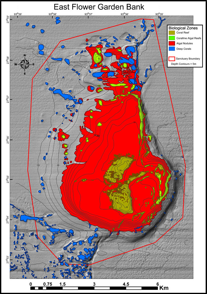
| Graphic of four major types of habitat within the boundaries (the red line) of the East Flower Garden Bank. Each habitat is shown in a different color. Coral reef areas are colored olive green, coralline algae areas are in lime green, algal nodules are in red and deep corals are in blue. Image produced by Doug Weaver. Click here for a larger view. |
|
|
A lot goes into selecting areas for protection, including years of scientific research, observation and discussions with numerous partners and citizen groups. But what then? How do you manage a place that not only is 100 miles off shore, but underwater?
“To know how to make meaningful management decisions, we have to know what the area and its surroundings look like,” says Steve Gittings, science coordinator for the NOAA National Marine Sanctuary Program. “We cannot protect and manage sanctuaries in a vacuum. We have to see and understand what lies beneath the waves.”
Uncovering the secrets of the deep is no easy task. It takes years of careful, deliberate exploration with ships, sonar, remotely operated vehicles and scuba gear to paint a detailed picture of the landscape, habitats and marine life of the undersea world. But, researchers say, this “characterization” work pays off.
Expeditions to Flower Garden Banks National Marine Sanctuary, for example, have revealed that some reefs may be connected to other banks in the northern Gulf of Mexico through low reef ridges previously unknown. These “habitat highways” likely provide protection and foraging grounds for animals traveling between the various banks.
Detailed habitat maps produced by sanctuary staff recently helped the NOAA Fisheries Service and the Gulf of Mexico Fishery Management Council determine the boundaries for “marine managed areas” known as Essential Fish Habitat and Habitat Areas of Particular Concern. These designations raised the protection level for these sensitive and unique habitats, which are used by fish sought by commercial and recreational fishermen.
“Increasing protection of areas outside the sanctuary may ultimately help protect resources within the sanctuary,” says Gittings. “They are all connected in some manner.”
To learn more about habitat characterization mapping at Flower Garden Banks National Marine Sanctuary, visit sanctuaries.noaa.gov/sos05/mapping.html
|


