Contact:
Shelley Dupuy
409-621-5151 x106
409-370-9525 (Mobile)
State of the Art Sonar Map Reveals New Details
of Sunken Civil War-era Warship
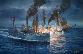 |
| The fatal battle between USS Hatteras and CSS Alabama on January 11, 1863, is depicted in a new painting by noted naval and maritime artist Tom W. Freeman using historical and archaeological data collected during the 2012 USS Hatteras project. (Copyright Tom Freeman/All Rights Reserved - Released for Media Use) |
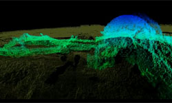
A new 3-D state of the art sonar map released today by NOAA's Office of National Marine Sanctuaries, ExploreOcean, Teledyne Blueview, and Northwest Hydro shows never-before seen details of the USS Hatteras, the only Union warship sunk in combat in the Gulf of Mexico during the Civil War.
One hundred and fifty years ago today, approximately 20 miles off the coast of Galveston, Texas, the Hatteras, an iron-hulled steamship the U.S. Navy converted into a gunboat, was sunk during a battle with the famous Confederate commerce raider CSS Alabama. The battle was one of the skirmishes that saw the key southern port of Galveston change hands twice and remain one of the last bastions of the Confederacy.
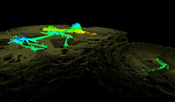 |
| This three-dimensional sonar scan shows remains of the USS Hatteras protruding above the seabed as surveyed in late 2012. For more sonar imagery click here. |
Today, the wreck of the Hatteras is largely intact, resting 57 feet underwater in sand and silt. Recent hurricanes and storms have removed some of the sediment and sand that once encased the vessel like a time capsule. Given shifting sands may once again rebury the Hatteras, the team used a short window of opportunity for a two-day mission last fall to create 3-D photo mosaics of the Hatteras for research, education, and outreach purposes.
"Most shipwreck survey maps are two-dimensional and based on observations made by sight, photographs or by feeling around in murky water while stretching a measuring tape," said James Delgado, director of maritime heritage for NOAA's Office of National Marine Sanctuaries. "Thanks to the high-resolution sonar, we have a three-dimensional map that not only provides measurements and observations, but the ability for researchers and the public to virtually swim through the wreck's exposed remains and even look below the surface at structure buried in loose silt."
Delgado said the survey revealed previously unknown details like the survival of most of one paddlewheel, as well as the fact that the ship's stern and rudder are emerging from the sand. The three-dimensional map also plots damage to engine room machinery and the ship's paddlewheel shaft, which seems to have bent when the ship capsized and sank after being shot full of holes.
"The engine room spaces were a dangerous place in the battle," Delgado said. "Cannon fire severed steam lines and filled these spaces with scalding steam. Fires broke out, and yet the crew stayed at their post to keep the ship running and fighting, and in here, two of them paid the ultimate price."
Listed in the National Register of Historic Places, the Hatteras was part of the 1863 West Gulf Blockading Squadron commanded by Union Rear Admiral David Farragut. The squadron was part of the U.S. Navy's efforts to block the passage of goods, supplies, and arms to and from the Confederacy on the Atlantic and Gulf coasts.
The USS Hatteras is located in federal waters administered by the Bureau of Ocean Energy Management (BOEM) and the Bureau of Safety and Environmental Enforcement (BSEE), but the ship itself is administered by the Navy. The vessel is protected by the Sunken Military Craft Act as a war grave.
BOEM, working with private cultural resource management firms and the state of Texas, has documented sections of the vessel that protrude above the seafloor. Previously acquired data illustrates the changing nature of the wreck site, and the current level of site exposure presented an opportunity to document the site.
 |
| Close up video of paddlewheel. |
Funding and support for the project was provided by the Edward E. and Marie L. Matthews Foundation, ExploreOcean, and Teledyne BlueView. Participants included NOAA's Office of National Marine Sanctuaries, BOEM, BSEE, the Texas Historical Commission, the U.S. Navy's History and Heritage Command, Tesla Offshore LLC, and private citizens including noted Houston underwater photographer and journalist Jesse Cancelmo, whose reports of the sand moving off the wreck prompted the project. NOAA, which manages Flower Garden Banks National Marine Sanctuary off the Galveston coast, provided vessel support. The detailed final maps were produced by James Glaeser of Northwest Hydro, Inc. of Skamania, Washington.
NOAA's mission is to understand and predict changes in the Earth's environment, from the depths of the ocean to the surface of the sun, and to conserve and manage our coastal and marine resources. Join us on
Facebook, Twitter and our other social media channels.