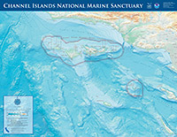
Aerial Surveys Look at Trends in Sanctuary Waters
The sanctuary aerial survey program was started in 1997 to perform marine mammal surveys, monitor vessel and visitor use within sanctuary waters, and to respond to emergencies such as oil spills. Known as Sanctuary Aerial Monitoring and Spatial Analysis, researchers are looking at how the recent establishment of no-take zones within sanctuary waters affects ocean users and their impact on the marine environment. Since the program began, researchers have seen changes in blue whale feeding locations over time, a distinct geographic delineation of areas used by recreational and commercial visitors, and significant increases in recreational use directly related to policy changes regarding island visitation. Click here for more information.
 |
|
A Lake Renegade Seawolf flies survey routes over California's Channel Islands. (Photo: NOAA Library)
|
 |
|
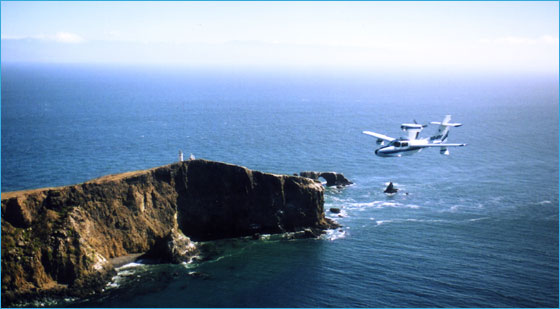
Aggi a 3-masted full-rigged ship stranded on Talcott Shoal in 1915 with a cargo of barley. (Photo: Monterey Maritime and History Museum)
|
Researchers Mount Shipwreck Expedition
A key mandate of the National Marine Sanctuary Program is to explore, characterize, and protect submerged historic resources and to share these discoveries with the public. To that end, a five-day shipwreck reconnaissance expedition in sanctuary waters in October documented several submerged heritage sites. Expedition team members surveyed the remains of a Grumman AF-2W Guardian airplane lost off Santa Cruz Island in 1954, and reported on the condition of F/V Reliance, a modern ship lost at Santa Rosa Island in 2005. Divers recorded a third site, the three-masted sailing ship Aggi lost 90 years ago off Santa Rosa Island. The shipwreck reconnaissance program has been an ongoing collaboration between the sanctuary office, National Park Service, Coastal Maritime Archaeology Resources, and State of California for nearly 25 years.
Sanctuary Volunteers Help in Two Innovative Cleanups
Sanctuary volunteers shined again when they removed more than 4,000 pounds of marine debris from Santa Barbara Harbor’s Marina 3 in Operation Clean Sweep, a sea floor debris removal effort, and scuba divers helped recover nearly 10 tons of abandoned fishing gear from waters around the Channel Islands. In Operation Clean Sweep, city officials hope to make this inaugural effort an annual event and cover all areas of the harbor. Channel Islands Naturalist Corps volunteers assisted with the harbor cleanup and reported that divers retrieved a wide variety of discarded items such as crab traps, bicycles, batteries, cans, and nets. The gear removed from Channel Islands waters included nearly 250 commercial lobster traps, many fishing rods and sport traps, and a huge fishing net covering 5,000 square feet of the seafloor. An important goal of this project, supported in part by NOAA’s Marine Debris Program, was to work with fishermen to locate debris and establish volunteer reporting among the fishing and maritime communities. The project was based at University of California at Davis.
 |
|
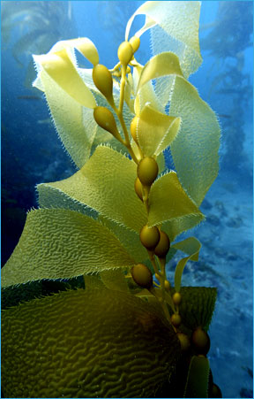
Kelp forests provide shelter and protection for a variety of marine animals. (Photo: Robert Schwemmer)
|
Researchers Monitor Kelp Forest Community
To evaluate whether marine protected areas in the Channel Islands are affecting the overall health of the ecosystem, researchers conducted surveys of fish, invertebrates, and algae in the kelp forests at and near the Channel Islands. Researchers with the Partnership for Interdisciplinary Studies of Coastal Oceans also retrieved and replaced devices that measure temperature and currents at five sites. The partnership has carried out a large-scale, long-term study of nearshore habitats and the physical and ecological processes responsible for structuring these communities. These monitoring efforts meet many goals of the National Marine Sanctuary Program including to “improve the conservation, understanding, management, and wise and sustainable use of marine resources.” The data will also be used in a statewide effort to establish other marine reserve networks.
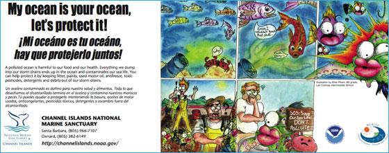
Cartoon Contest Winners Get ‘MAD’ Prizes
Sanctuary staff hosted the first ever cartoon contest with an environmental message for 8th-12th grade students as part of a new outreach strategy called Multicultural Education for Resource Issues Threatening Oceans (MERITO). MAD Magazine cartoonist Sergio Aragones presented cash prizes to Elise Pham, grand prizewinner, and five runner-up winners. The selected cartoons promote protection of the sanctuary waters, coastal watersheds and the importance of ocean water quality to a bilingual audience. Additionally, sanctuary staff produced bus signs with the grand-prize winner’s cartoon strip that were placed on Ventura and Santa Barbara city buses. An estimated four million passengers, the majority Hispanic, ride the buses where the cartoon signs were placed. The sanctuary program launched MERITO in 2002 as a marine conservation effort designed to reach culturally diverse groups including students, teachers, adults and families living near the Monterey Bay and Channel Islands national marine sanctuaries.
 |
|
Winning entry for MERITO cartoon contest (Photo: Elise Pham)
|
Plans for 2007
- Complete the federal designation process for expansion of Channel Islands marine protected area network into federal waters.
- Release the final version of the sanctuary management plan by end of 2007.
- Conduct approximately 160-180 days at sea of research and monitoring to study the Channel Islands marine protected area network.
- Enhance education and outreach partnerships with the National Park Service and State of California.
Sanctuary Atlas Maps
New sanctuary atlas maps depicting physical ocean and land features, other state and federal
managed areas and parks, and other basic atlas features are now available on the sanctuary program Web site.
Click here to view print version. (pdf, 552K)
|