|
Maritime Heritage
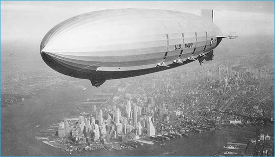
Navy Airship Gets Revisted
The wreck of the USS Macon, the U.S. Navy’s last dirigible, got another look in September when a team of NOAA researchers explored its remains. The Macon was lost in a storm in 1935 and now rests in 1,500 feet of water in Monterey Bay National Marine Sanctuary. Researchers are producing photomosaics of the site’s debris fields, a technique that combines separate smaller images into one large image. Photomosaics are an important tool for devising a management strategy for this unique part of Navy aviation history.
 |
|
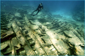
Exploring the Dunnottar Castle wreck at Kure Atoll. (Photo: Robert Schwemmer)
|
New Wreck Explored in Northwestern Hawaiian Islands
Marine archaeologists surveyed a newly discovered wreck, the Dunnottar Castle, while on a summer expedition to the Northwestern Hawaiian Islands. The iron-hulled British sailing ship sank in 1886 while en route from Sydney to California. Archaeologists also investigated other shipwrecks, including a 19th-century American whaling ship and the USS Saginaw that sank there in 1870.
 |
|
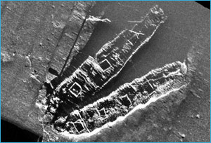
Side scan sonar image of the Frank A. Palmer and Louise B. Crary (Photo:
NURC-UConn/NOAA)
|
Two Schooners Get Top Listing
The Frank A. Palmer and Louise B. Crary, which rest on the seafloor of Stellwagen Bank National Marine Sanctuary, have been added to the National Register of Historic Places, the nation's official list of cultural resources worthy of preservation. The 19th century coal schooners embody a distinctive vessel type and their archaeological remains will likely yield important historical information.
Researchers Map Shipwrecks in Florida Keys
 |
|
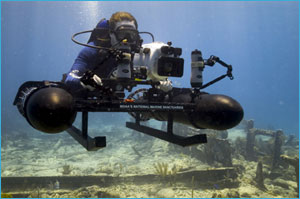
Archaeologist photographing wreck site. (Photo: Russ Green)
|
Archaeologists deployed a newly developed propulsion sled to create high-resolution photomosaics of five shipwrecks on Florida Keys National Marine Sanctuary’s Shipwreck Trail. Archaeologists “flew” over the wrecks while high-resolution cameras on the sled captured multiple images of the shipwrecks below. The mosaics are pieced together digitally to create a detailed image of each wreck, which will help researchers monitor changes in these sites over time. With photomosaics, a new window will open up for those who want to preserve and experience a piece of America’s maritime history.
|