 | |||||||||||||||
|
|
|
|
|
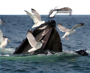
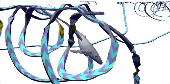
Shipping Lane Shifts Reduces Risks to WhalesThe sanctuary is a critical seasonal feeding area for endangered humpback, finback and the remnant population of North Atlantic right whales (researchers believe less than 400 remain in the world). It is also an area where large, commercial ships – to the tune of nearly 200 per month - enter the Port of Boston. Sanctuary scientists analyzed more than 20 years of over 250,000 whale sightings collected by the Provincetown Center for Coastal Studies, Whale Center of New England and North Atlantic Right Whale Consortium to determine the areas in which the highest concentrations of whales are regularly found. This research paid off in a big way when the International Maritime Organization approved a shift in shipping lanes in the region, to become effective in July 2007. The move will reduce the risk of ship strike to critically endangered right whales by up to 58 percent and all large whale species by up to 81 percent. This will provide a major safeguard for these marine mammals that are a thrilling component of the sanctuary’s biodiversity. Sanctuary staff worked closely with the NOAA Fisheries, NOAA General Council, U.S. Coast Guard and the local maritime transportation industry to accomplish the protective shift. Acoustic Studies Offers Means of Detecting Whales in Sanctuary WatersTen acoustic pop-up buoys that record sounds in the sanctuary may prove to be a means of monitoring the distribution of endangered whales by pinpointing their distinctive vocalizations. Through the use of the buoys, the team has developed an acoustic array that covers over 85 percent of the sanctuary. A better understanding of the temporal and spatial aspects of right whale distribution will help the sanctuary protect the animals from ship strike and entanglement in commercial fishing gear. The project also served as a model for the mitigation effort developed for the proposed Liquid Natural Gas terminals in Massachusetts Bay. Sanctuary scientists are collaborating with researchers from NOAA Fisheries and Cornell University on the project. The team is also using sound data in a pioneering effort to measure noise in the sanctuary. Human produced noise in the ocean has increased dramatically over the past few decades. Because light travels only short distances in the ocean, many types of marine life, including whales and dolphins, use sound for key activities such as communication and feeding. Unwanted noise can mask sounds produced by animals and interfere with their ability to find food or each other. Vessel Tracking Sheds New Light on Sanctuary UseThe sanctuary is collaborating with the U.S. Coast Guard’s Research and Development Center to document and track the passage of large commercial vessels. The project uses the Coast Guard’s Automatic Identification System and three newly established receiver stations around the sanctuary to gather continuous data on the location and speed of boats through the area. This information will allow the sanctuary to describe patterns of vessel use. When combined with data from the acoustic buoys, it will also allow scientists to investigate noise generated from commercial ships using sanctuary waters. Humpback Whale Behaviors Underwater Now RevealedIn a continuing project that began last year, scientists from the sanctuary, NOAA Fisheries and several academic institutions have been tagging humpback whales to study their behaviors. Non-invasive suction-cup tags developed at the Woods Hole Oceanographic Institution record depth, heading, pitch, roll, and sounds made and heard by the animals. Until now, whale behavior studies were based primarily on surface activity. With this project, data collected from the tags can be programmed into visualizations that show a whale’s underwater movements. This year, the movements have been correlated with information about seafloor topography, prey concentrations, and with tracks and sounds of vessels in the area. New GeoZui4D and TrackPlot software from the University of New Hampshire now allows almost immediate production of visualizations from downloaded tag data. Distinctive behaviors, such as bubble nets and bottom feeding, theorized but never observed underwater, have now been recorded by the tags. Analysis of the tracks may lead to a better understanding of whale behavior and lead to more informed decision-making in managing ocean areas for the protection of endangered great whales.
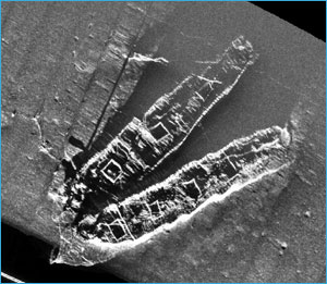
Two Sunken Schooners Listed on National Register of Historic PlacesIn April 2006, the wrecks of the coal schooners Frank A. Palmer and Louise B. Crary, which rest on the sanctuary’s seafloor, were listed on the National Register of Historic Places, the nation's official list of cultural resources worthy of preservation. These vessels represent excellent examples of the great coal schooners that served the East Coast during the turn of the 20th century. The ships qualified for listing on the National Register of Historic Places by meeting three criteria: 1) they were associated with events that made a significant contribution to the broad patterns of American history; 2) they embodied the distinctive characteristics of a type, period and/or method of construction; and 3) their archaeological remains have yielded, or will likely yield, important historical information. Sanctuary Exhibit Unveiled at the Gloucester Maritime Heritage CenterThe Gloucester Maritime Heritage Center unveiled new exhibits featuring the marine life, habitats and shipwrecks of the Stellwagen Bank National Marine Sanctuary. A major component to the exhibit is a three-dimensional seafloor map with lights that indicate the significant habitat types within the sanctuary and the sanctuary’s gateway communities on land. The Gloucester Maritime Heritage Center is open daily from Memorial Day Weekend through October, and by appointment throughout the rest of the year. Divers Come Out in Force to Support Fish Count and Sanctuary CelebrationFor the fifth year in a row, the sanctuary hosted the largest one-day Great Annual Fish Count event in the nation. This year, 86 divers submitted 134 surveys from dives around Cape Ann, Mass., and the New Hampshire coastline. These surveys give divers the opportunity to lend their voices to ocean conservation and marine education efforts. Plans for 2007
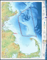
Sanctuary Atlas MapsNew sanctuary atlas maps depicting physical ocean and land features, other state and federal managed areas and parks, and other basic atlas features are now available on the sanctuary program Web site.
Click here to view print version. (pdf, 512K) |
|
||||||||||
|
|||||||||||||||