 |
|
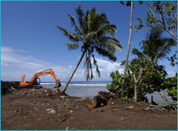
Excavator clears a section of land. (Photo: Richard Murphy, Ocean Futures Society)
|
Program Looks at Ways to Stop Soil Erosion
Sanctuary staff are working with local partners to mitigate the effects of land clearing on the ridge slopes above Fagatele Bay. The forest clearing has expanded in recent months and may be impacting sanctuary water quality. To help control soil erosion, a project is in development to plant rows of vetevier, a non-invasive grass, within the taro plantations. Students from the American Samoa Community College will measure the amount of soil transport in areas planted with the grass and compare this to plantations without it. Researchers hope this effort will engage landowners in better land-use practices and help to promote stewardship of American Samoa’s forests and adjacent coastal environments. This project is a collaboration with U.S. Department of Agriculture National Resource Conservation Service, American Samoa Land Grant and the American Samoa Community College.
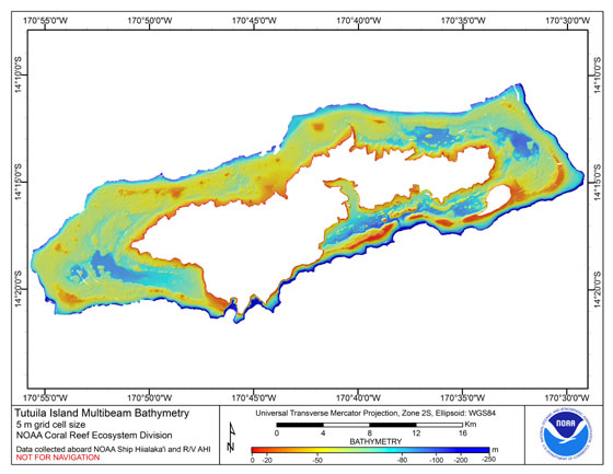
Research Cruise Produces New Findings
NOAA scientists aboard NOAA ship Hi`ialakai visited American Samoa in early 2006 to conduct a month-long monitoring cruise of the region’s coral reefs and marine habitats. The research team also completed multi-beam bathymetric mapping of American Samoa’s shallow and deep-water coral reef habitats that provide significant new understanding of where reefs are found and how to protect them. The deep offshore banks and reefs the survey identified highlight the need to characterize and potentially protect these areas from fishing, as they may be key to sustaining shallow near-shore coral reefs and their fisheries.
 |
|
Bathymetric map of American Samoa. Red areas are shallow banks and reefs
surrounding the island.
|
Bay Water Quality Monitored
Sanctuary staff collaborated with the American Samoa Environmental Protection Agency to establish water quality monitoring protocols for the sanctuary. This effort will expand the agency's island-wide beach water quality monitoring to include monitoring the sanctuary for bacteria. It will provide a baseline to judge potential changes in water quality if human use in and around Fagatele Bay increases. Researchers hope that these procedures can be expanded to include other contaminants that could enter the bay from springs, coastal runoff and other sources.
Fagatele Bay Staff and Ocean Futures Launch Education Program
To help Samoans develop stewardship for their coral reefs, Jean-Michel Cousteau’s Ocean Futures and Rock and Waterscape International launched the Sustainable Reefs Program in American Samoa. A free, innovative education package that includes a DVD, cartoon book story, and an ocean science curricula and activities guide was given to schools, educators and other groups dedicated to coral reef protection in American Samoa. The sanctuary program coordinated the launch of the education initiative. Sustainable Reefs was also featured in Cousteau’s PBS film, America’s Underwater Treasures.
 |
|
Céline Cousteau and Richard Murphy, foreground, with Samoan children during filming of America’s Underwater Treasures. (Photo: Carrie Vonderhaar, Ocean Futures Society)
|
Samoa Waters Key for Protecting Humpback Whales
Recent studies have shown that American Samoa is a significant habitat for humpback whales. During 2006 surveys, researchers documented a record number of whales in American Samoa waters. Up to eighteen individuals were sighted in a single day over a relatively small area west of Tutuila. This area is part of a recently mapped system of submerged reefs and banks that surround Tutuila and extend up to five miles offshore. The shallow areas provide unique habitats where humpback whales calve and breed after spending the southern summer months feeding in Antarctic waters. Whale research in American Samoa is a collaborative effort between the National Marine Sanctuary Program, National Park Service, American Samoa Department of Marine and Wildlife Resources and the Western Samoa Government.
 |
|
Humpback whales often calve and breed in Samoan waters. (Photo: Paul Brown)
|
Twenty Years Serving Samoa
Fagatele Bay reached a milestone in 2006 – 20 years as a national marine sanctuary. To celebrate the event, sanctuary staff, the American Samoa Department of Commerce, Ocean Resources Management Council and the American Samoa Community College sponsored a forum 2010: Balancing Ocean Uses with Conservation. The forum’s recommendations to the territory included increased community involvement in environmental stewardship, better enforcement of environmental laws, balance development with conservation, find ways to utilize by-catch from fisheries, and provide incentives for students to pursue degrees in marine science and policy.
Plans for 2007
- Staff will begin their management plan review process to evaluate the role the sanctuary program can play in helping the territory manage and protect its marine environment.
- The sanctuary office will play an important role in the territory's hosting of the U.S. Coral Reef Task Force meeting scheduled for August 2007. This will include engaging the participation of regional South Pacific island nations and build more regional collaboration in coral reef management and conservation efforts.
- In collaboration with the American Samoa National Park, a nature trail is being constructed that will link Fagatele Bay to adjacent Larson's Bay and the coastal villages to the east and west. This trail will provide better access for visitors to the sanctuary, and will give a wider public understanding of the sanctuary and stake in protecting the coastal environment.
Sanctuary Atlas Maps
New sanctuary atlas maps depicting physical ocean and land features, other state and federal
managed areas and parks, and other basic atlas features are now available on the sanctuary program Web site.
Click here to view print version of this report. (pdf, 552K)
|