Coastal Discovery Center Opens
The sanctuary’s first public visitor center opened its doors in July in partnership with California State Parks. Located at Hearst State Beach, the small but vibrant Coastal Discovery Center at San Simeon Bay highlights the marine ecosystem of the Monterey Bay National Marine Sanctuary and California’s Central Coast. Exhibits include the first public display about Davidson Seamount, video voyage to the wreck of the Montebello, a talking tidepool, and a 150-gallon steelhead tank. Visitors can see how their activities on land affect the ocean and how the ocean affects them. The center anticipates more than 10,000 in its first year of operation.
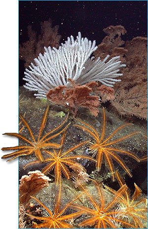 |
Corals and feather stars on the Davidson Seamount at 2669 meters. (Photo: NOAA/MBARI) |
|
Scientists Study Deep Sea Corals on Davidson Seamount
In January 2006, researchers journeyed to the Davidson Seamount to understand why deep-sea corals live where they do, determine age and growth patterns of these corals, and identify what species live there. Scientists placed markers at specific locations in the area to help make future photographic measurements and determine growth rates of the giant corals, some as old as 200 years. More than 70 hours of observations were recorded. Hundreds of images and video clips can be viewed on the NOAA Ocean Explorer Web site. The Davidson Seamount is proposed for inclusion in the sanctuary to protect these slow growing, deep water corals and other species associated with the unique underwater environment.
 |
|
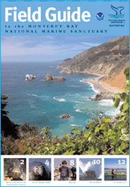
The field guide can be used as a travel guide or for educa-tional purposes. (Photo: NOAA)
|
New Monterey Bay Sanctuary
Field Guide
A new sanctuary publication, Field Guide to the Monterey Bay National Marine Sanctuary is now available. The 12-page publication is designed for both visitors and residents, and encourages exploration, enjoyment and protection of the sanctuary. The guide introduces readers to the sanctuary’s natural wonders and ways to experience its beauty by foot, boat, bike or car. Readers will find information on sanctuary habitats, descriptions and photographs of common wildlife and information on the best times and places to see wildlife. The guide also includes tips for watching wildlife responsibly and keeping sanctuary waters clean. A detailed map of the central California coast identifies points of interest, and features things to do in and around the sanctuary. Copies are available from the sanctuary office and can be downloaded from the sanctuary’s Web site.
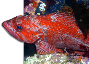 |
Vermillion rockfish. (Photo: Chad King) |
|
New Image Database Available to the Public
The Sanctuary Integrated Monitoring Network (SIMoN) now boasts a new searchable database of more than 2,500 digital images showing the sanctuary’s unique collection of animals, plants and habitats. Visitors can search by species name or keyword and then download high-resolution images. The database contains a vast collection of marine life images as well as images from research projects and locations throughout the sanctuary. This proven resource continues to grow monthly as 56,700 images have already been viewed.
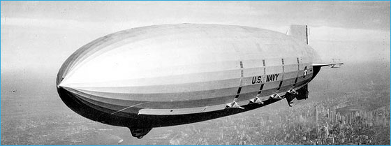
Revisiting the USS Macon
The U. S. Navy’s last dirigible got another look in September when a team of NOAA researchers explored the remains of the USS Macon. This was the first large scale maritime heritage project in the sanctuary. Researchers completed over 40 hours of deepwater surveys at the wreck site, documenting two major debris fields. Among the airship’s artifacts located were five of the Macon’s eight gasoline engines, and the remains of four Curtiss F9C-2 Sparrowhawk biplanes. Grant funding for the expedition was provided by NOAA Office of Ocean Exploration, NOAA National Marine Sanctuary Program, NOAA Preserve America Initiative and the Monterey Bay Aquarium Research Institute. The expedition fulfilled a key mandate of the National Marine Sanctuary program and that is to explore, characterize, and protect submerged historic resources and to share these discoveries with the public. Streamed live over the Internet at OceansLive.org and on Monterey Bay’s sanctuary Web site, over 30,000 hits were received from five continents in a four-day period.
 |
|
USS Macon over Manhattan. (Photo: U.S. Navy)
|
Volunteers Conduct Annual Water Quality Monitoring
Monterey Bay sanctuary held its seventh annual Snapshot Day to gather water quality data from creeks entering the sanctuary. Approximately 160 volunteers gathered to monitor the health of 197 sites on creeks from Pacifica to Morro Bay, Calif. Snapshot Day is a one-day water quality monitoring event on the Central Coast that utilizes volunteers to collect and analyze water samples. The hard work of sanctuary volunteers allows sanctuary staff to have a comprehensive look at water quality that would not be possible without their dedication.
Plans for 2007
- The sanctuary’s revised draft management plan was released in October 2006 and will be finalized in 2007. Twenty-eight action plans outline the many issues facing sanctuary resources including desalination, marine protected areas, inclusion of Davidson Seamount in the sanctuary, interpretive facilities, tidepool protection and beach closures.
Sanctuary Atlas Maps
New sanctuary atlas maps depicting physical ocean and land features, other state and federal
managed areas and parks, and other basic atlas features are now available on the sanctuary program Web site.
Click here to view print version. (pdf, 620K)
|