Location
The Special Location: Lāna`i Island’s Shipwreck Beach
 |
|
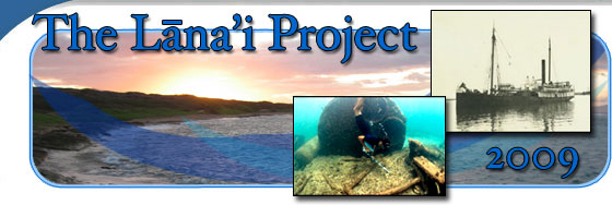
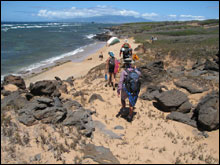
The north shore coast during the 2.5 mile hike back to camp, with the hull of the Bacchus on the beach, and the navy barge YOGN-42 on the distant horizon. (H Van Tilburg/NOAA ONMS)
|
The north shore of Lāna`i is unique, for among the many miles of coastline surrounding the islands of Hawai`i there is one particular area which possesses by far the greatest share of historic wrecks from the days of sail and steam. The rough and treacherous north shore, particularly within the ahupua`a or traditional Hawaiian land divisions of Paoma`i and Mahana, features the wrecks of many inter island steamships. This area is also known locally as Shipwreck Beach. The six-mile stretch of lava rock and sand today features opportunities for hiking, fishing, and photography. Many people visit the eastern end of Shipwreck Beach to see the hulk of the YOGN-42, a navy fuel barge upright and locked in the reef near Pō`aīwa (also a former settlement and location of petroglyphs). However, regarding the many other historic shipwrecks, there is little information currently available to the public.
 |
|
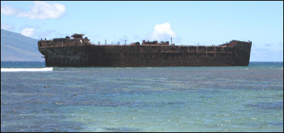
The stout navy fuel barge YOGN-42, hard aground on the reef and broadside to the weather, as she has been for decades. (H Van Tilburg/NOAA ONMS)
|
 |
|
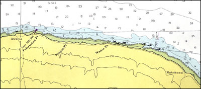
Seven wrecks, each with a portion of hull or superstructure above the surface, located on the 1973 chart for Shipwreck Beach, Lāna`i. Click here for a larger map. (US Coast and Geodetic Survey 4120)
|
The Ocean Environment: Accidental Losses and Intentional Deposition
In a very real sense, the forces of wind and current have conspired to make Lāna`i’s north shore the ship’s graveyard of Hawai`i’s maritime past. The strong prevailing trade winds blowing east-northeast across Hawai`i are funneled through the gap between the islands of Moloka`i and Maui. Lāna`i ‘s north shore lies immediately downwind from this gap. Vessels emerging from the wind shadow in either direction are struck by the sudden gusts and the rough conditions of the channel, and find themselves facing a lee shore. Any ships cast loose from their moorings at Lahaina, Maui, will drift quickly onto Lāna`i’s reef. These conditions along the Kalohi Channel also allowed 19th-century steamship owners to carelessly dispose of aging vessels simply by releasing them near Lāna`i’s shore. The stripped hulks would beach themselves, rather than remain adrift as navigational hazards. Deposition at Shipwreck Beach reflects a combination of accidental shipwrecks and intentional groundings. Fortunately, we now know more about the long term effects of ship disposal.
The Ahupua`a of Paoma`i:
 |
|
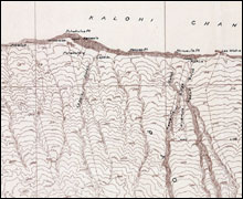
Historic map of the north shore of Lāna`i, depicting the ahupua`a land division of Paoma`i and the Hawaiian names for specific locations. Click here for a larger map. (University of Hawai`i map collection)
|
The land area of Paoma`i refers to the Hawaiian chief Pao, who named a hill near Lahaina “Pu`u Lāna`i” (Lāna`i Hill). Exhausted after making his crossing to Maui, he was known as sick Pao (Paoma`i). This western section of Shipwreck Beach stretches from longitude 157 00.80W to 156 56.30W and includes the coastal locations of Hale o Lono, Awalua, Honowae, Pohakuloa Point, Kanaele, Paopao Point, Honuaula Point, and Kahue.
Specific locations in Paoma`i possess cultural and historical meaning. Hale o Lono, or House of Lono, at the western end of Paoma`i, featured an ancient heiau or temple dedicated to Lono, the god of peace and fertility, associated with agricultural and planting traditions. Awalua Bay (Double Channel Bay) was the site of a traditional village, as well as a steamship landing area during the ranching days of Lāna`i. Here, sheep and cattle were rounded up by paniolos (local cowboys) and, lashed to whaleboats, made to swim out to the waiting steamers, where they were loaded for transport to Honolulu. Awalua Bay was also the site of the 2001 Maritime Cultural Resource Survey, a University of Hawai`i Marine Option Program project focusing on two shipwrecks, the navy yard oiler YO-21 and an inter island steamer presumed to be involved in the cattle trade (see Project History). The YO-21 marks the western end of Shipwreck Beach. The coast between Kanaele (a former village site near a rocky cleft) and Paopao Point contains several major concentrations of large ship timbers, all cast ashore during significant storm events. A modern trimaran sailing vessel is embedded in the sandy shore just west of Honuaula Point. To the east of Kahue a sunken steel barge lies in near shore waters. Steamship machinery, submerged in the surf, appears just west of Lae Wahie or Firewood Point. This location is also called Yamada’s, referring to the Japanese fisherman Yasukichi Yamada, who traveled on mule-back to this coast to supply his fish market on Lāna`i.
The Ahupua`a of Mahana:
 |
|
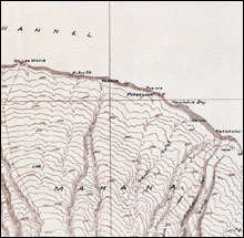
Historic map of the north shore of Lāna`i, depicting the ahupua`a land division of Mahana and the Hawaiian names for specific locations. Click here for a larger map. (University of Hawai`i map collection)
|
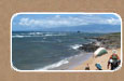
The eastern section of Shipwreck Beach stretches from longitude 156 56.30W to 156 53.00W, and includes the named locations of Lae Wahie (Firewood Point), Kukui Point, Kuahua, and Pō`aīwa (Ninth Night). There are a greater number of large ship timber concentrations in this area. The 2009 survey work was conducted between Lae Wahie and Kukui Point, not far from the wreck of a modern fiberglass sloop Bacchus. East of Kukui Point shipwreck timbers have been fashioned into shelters for fishermen, and another modern sailing vessel, Romar III, lies half buried in the sand. Keel and keelson timbers, large frames and sections of deck planning and areas of scattered iron ship fasteners, litter the coast between Kuahua and Pō`aīwa. The large ferro-concrete navy fuel barge YOGN-42 marks the eastern extent of Shipwreck Beach.
The 1973 chart of the waters surrounding Lāna`i show six emergent hulks within the two-mile stretch of coastline between Lae Wahie and Pō`aīwa alone. Over time, the emergent wreck symbol was removed from navigational charts, as the vessels broke apart on the rugged shore.
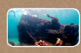
Once the team had established the base camp on the coast (tents, portable cooking facility, equipment storage and drawing tables etc.), the divers were then ready to head out on the daily five mile round-trip trek, carrying all the survey and ocean equipment needed to-and-from the wreck site. (Proximity to shore allowed for free diving, so no heavy scuba tanks!) Water and supplemental supplies were brought by truck from Lāna`i City.
Kaiolohia Bay and Federation Camp:
The Hawaiian word Kaiolohia describes the smooth sea of this sheltered bay at the eastern end of Shipwreck Beach. The area is also sometimes known simply as “Shipwreck.” During reconnaissance of the survey area in June 2009, project staff received permission to establish the survey camp at Kaiolohia Bay, setting up tents around the group of the buildings known as Federation Camp.
 |
|
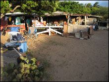
One of the beach structures at Federation Camp on Kaiolohia Bay. This building was originally constructed in the 1920�s by the Calibes family. (H Van Tilburg/NOAA ONMS)
|
Federation Camp itself has a fascinating history relating directly to the plantation period in the Hawaiian Islands. For many years, the island of Lāna`i was the largest pineapple plantation in the world, owned by Dole Pineapple Company (later Dole Food Corporation). Plantation laborers came from many different locations. By the 1930’s, Lāna`i’s population reflected a multicultural plantation society: Korean, Puerto Rican, Chinese, Caucasian, Portuguese, Hawaiian, Japanese, and Filipino.
The Filipino Federation of America (FFA) was a mutual aid society, formed in 1925 in response to contract labor migration and the difficult working conditions throughout the Pacific region. Some of the beach shacks on Lāna`i’s coast were built in the 1940’s by the local FFA organization as a meeting place, a place to relax during the brief respite from field labor. In fact, some of the timbers used in the construction of the camp came from the 19th century ruins of the Maunalei Sugar Company village at Keomoku. Over the years these shacks have been maintained by local families as recreational spots. The 2009 survey team was fortunate to have shelter for the food stores and equipment, and camp at a location associated with plantation history while diving on a plantation-era steam vessel.
Location, and Recognizing the Value of in situ Preservation:
There are those who hold that maritime archaeologists have an obligation to recover all the artifacts from shipwreck sites, because if left underwater they will eventually all disappear. While there might be some truth in that, it is simply not always feasible to conduct this amount of costly excavation and conservation. The key concepts of in situ preservation focus on preventing the intentional or inadvertent human destruction of a heritage resource like an historic shipwreck (through dredging, looting, net and anchor damage etc.) and understanding and appreciating that resource while it exists. For removing shipwreck artifacts from their specific location destroys their context, the meaning derived from their environment. And at Shipwreck Beach, within the ahupua`a of Paoma`i and Mahana, locations have cultural and historic meaning and value.
The 2009 survey aimed to understand and appreciate the historic resources all around us every day, and to value their coastal and marine locations, rather than remove them for display elsewhere. Not only did all the participants learn about the history and construction of steamships in Hawai`i, but they were also exposed to local perspectives of land and sea, and to the plantation history of Federation Camp, and the current fishing practices on the north shore, and most of all to the people of Lāna`i themselves. The historic sites on this coast are part of a complex cultural landscape, where environment and history and culture come together to create a place unique among the islands. Only by appreciating these multiple perspectives can we gain a better understanding of the real value of coastal and marine spaces.
|