Methods
Survey methods for the 2009 project emphasized two basic goals: 1) recovering information from the wreck site, and 2) interpreting this information in the context of Hawai`i’s plantation-era past. To do this, the Return to Shipwreck beach project included a training phase on O`ahu, and a field survey phase on Lāna`i. Students were introduced to maritime archaeology survey methods in the classroom, and then practiced these techniques at an underwater training site. But preparing for a heritage resource survey requires much more than just learning the data collection methods. Preparations also included adapting data collection methods to Hawai`i’s environment, and gaining an understanding of the resource by learning about inter island steam navigation and to the history of Lāna`i.
Training, and the Waimānalo Plantation Landing
 |
|
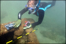
Establishing the baseline at the Waimānalo beach training site on O`ahu. (J Coney/NOAA ONMS)
|
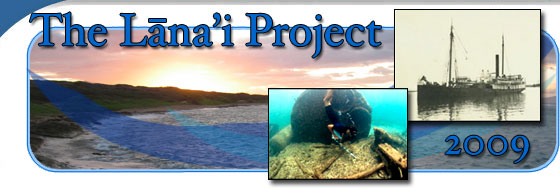
Baseline trilateration is the standard low-impact hands-on method for mapping wreck sites in relatively shallow waters. First, a reference or “baseline” is temporarily placed on the bottom through the wreck site. Then measured plan view sketches, from above looking down, are made of all the major features and artifacts. (These sketches are backed up by digital photography where conditions allow.) The position of all of these features can then be accurately recorded by recording measurements to known points on the baseline. Finally, the wreck site plan or map is drafted to scale on a roll of architectural graph paper, and then digitized.
 |
Parts of the rotating crane at the Waimānalo training site, the submerged landing ruins on O`ahu.
(T Casserley/NOAA ONMS)
|
Usually the labor intensive and time-consuming task of mapping a shipwreck site is conducted while scuba diving. The rough terrain on Lāna`i, inaccessible to vehicles, meant that the 2009 team had to hike two and one-half miles to the wreck site, and this ruled out the use of scuba equipment. Fortunately, the wreck’s shallow depth and proximity to shore allowed for snorkeling or free diving techniques. And O`ahu has an excellent training site for shallow water free diving baseline trilateration, the submerged ruins of a 19th century steamship landing. This was the perfect spot for the team to practice the synchronized timing required to set up the baseline underwater and sketch submerged equipment, all while breath holding. Baseline trilateration was adapted to shallow water free diving techniques.
The underwater training site tells its own story of the maritime past. The Waimānalo plantation was established in 1877 when plantation owner John Cummins (son of Thomas Cummins, who raised cattle, sheep, and horses in the area) started construction of the sugar mill. Product from the mill was shipped to Honolulu via the Waimānalo Sugar Company’s coastal steamer SS Waimānalo (later renamed SS John A. Cummins or Kaena). The railroad tracks from the mill culminated at a long wooden pier, extending 650 feet offshore. At the end of the pier winches and cranes lifted the bags of sugar onto the vessel alongside. Today this portion of Waimānalo history, the line of broken pilings and all the landing’s machinery and crane and rigging, lies submerged beneath 12-15 feet of water at Waimānalo Beach Park.
Background: Archives and the Hunt for History
 |
|
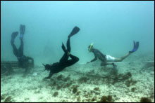
Diver conducting photo documentation of the major features of the wreck site. (J Coney/NOAA ONMS)
|
Two days of the week long training period on O`ahu were spent in the libraries and archives, gaining an introductory understanding of the historical background to the project. The search included the Hawaiian Historical Society at the Mission House Museum and the Bernice P. Bishop Museum, as well as the University of Hawai`i’s Hawaiian and Pacific collection in Hamilton Library and the University’s map collection. The Lāna`i Culture & Heritage Center’s online resources provided valuable information about island history as well. Finally, a visit to the O`ahu Train Museum near Barber’s Point helped give the students a feel for the type of steam engine machinery they would see at the wreck site.
Field Survey on Lāna`i
 |
|
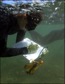
Taking notes in the water on slates and mylar. (J Coney/NOAA ONMS)
|
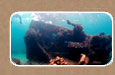
The research team flew to Lāna`i on July 11, and spent 10 days conducting the wreck site survey. The typical day began with a quick breakfast in camp. Lunches and survey equipment were then packed for the two and one-half mile hike to the remote site. The trek started at 6:30 AM to maximize survey hours before the prevailing trade winds made the ocean conditions unworkable. Once at the site, the team dressed out in full wetsuits for protection from the sharp-edged features of the wreck, and went to work conducting the measured sketching, baseline trilateration, and underwater photography. The temporary shoreline reference datum was recorded by Garmin GPS (WGS84) with reported accuracy of 46 feet. The shoreline sketch was completed by tape-and-compass method, and the major features of the wreck site, including the endpoints of the baseline, were plotted by triangulation from multiple features on the shore. Basic tools included handheld GPS units, digital cameras, underwater survey slates and tapes, photo scales, snorkeling equipment, folding rulers and pencils. By early afternoon the ocean conditions became too rough for safe diving, and the team began the trek back to camp.
 |
|
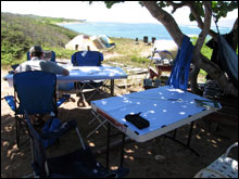
The drawing tables at camp, where students created the site plans. (H Van Tilburg/NOAA ONMS)
|
After cleaning up from the hike, the students completed their notes, and transcribed the detailed drawings from their dive slates onto the large format site plan. The benefit of drawing the site map while still conducting the site survey is that any missing data can be quickly addressed, the divers returning to the site the following day to fill in the blanks. Meanwhile the project staff used the truck into Lāna`i City for the daily water and ice run, and the cooks prepared dinner in camp. The 12-hour work day ended at 6:30 PM, leaving the rest of the quite evenings for enjoying the natural beauty of the island.
 |
|
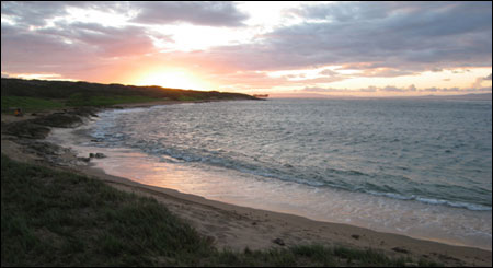
Sunset on Kaiolohia Bay, looking towards Pō`aīwa, the grounded YOGN-42 in the distance. (H Van Tilburg/NOAA ONMS)
|
Links:
Lāna`i Culture & Heritage Center
Bernice P. Bishop Museum
Hawaiian Historical Society
University of Hawai`i at Mānoa library
O`ahu Train Museum
|