Error processing SSI file
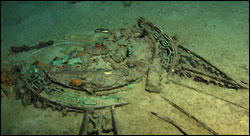
Plastic cup wedged beneath the side of a deck bench. |
The 2010 Scientific Expedition to Titanic
In August 2010, The Office of National Marine Sanctuaries joined a coalition of government and private partners to conduct a comprehensive scientific mapping of the entire Titanic wreck site. The mission's primary goal was a detailed archaeological map of the entire site - every scattered artifact and section of hull that rests on the sea bed, two and a half miles beneath the surface of the North Atlantic.
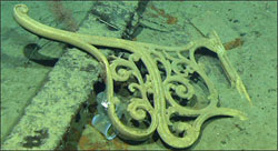
The aft grand staircase dome. |
2010 Expedition Results
The final archaeological report on the 2010 archaeological mapping expedition is currently being written. This work began in late 2010 after the initial processing of terabytes of data collected. The data resulted in a sonar map at various degrees of resolution that narrowed the survey areas from the maximum extent of scattered artifacts and wreckage to close-up views of specific clusters of "features".
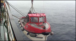
The work boat launched over the side of the Keldysh in order to aid in the deployment of the Mir submersibles. |
Previous Missions to Titanic
In the immediate aftermath of the sinking, proposals to locate the sunken Titanic were discussed and ultimately dismissed because the wreck lay well beyond the limits of technology at that time. Through the decades, the development of subsea technology finally provided the means to locate the wreck.
|