|
Science at Sea
Scientists on the Flying Bridge
In an effort to better understand the biological resources of the Gulf of the Farallones and Cordell Bank National Marine Sanctuaries, the sanctuaries along with Point Reyes Bird Observatory (PRBO) Conservation Science are collecting ecosystem information needed to estimate density and abundance of seabirds and mammals, as well as documenting frontal zones, marine debris and other wildlife. At sea-observations of birds and marine mammals currently provide the best source of data to obtain standardized density estimates by species, bioregion and season.
 |
| Observation Scientists on Flying Bridge. (Photo: Jamie Hall) |
Each day, we follow “standard strip-transect survey” methodology, surveying marine wildlife and frontal zones found within a certain width as we proceed along a set of predetermined transect lines. For our survey, we census birds, pinnipeds, sea otters, fish at the surface, drift algae, jellies, sea turtles and the location of frontal zones out to 300 m (986 feet) and cetaceans, vessel activities and albatross out to 800 m (2629 feet). Some transect courses are straight lines with no stops; other transect lines require periodic breaks in order to collect oceanographic readings or water samples. See the Charting our Course Section.
Our wildlife observations require a minimum of two observers and one recorder to complete the tasks of identifying and recording the animals, marine debris and vessels seen in our study area. On this cruise, we have two observers and two recorders. One observer is responsible for identifying birds, pinnipeds and turtles. Another observer identifies the cetaceans (e.g. whales, dolphins and porpoises). Two observers record the sightings and the respective details such as name and number of species, the behavior (i.e. feeding, flying, sitting on the water) and direction of travel. The recorders also note the latitude, longitude and environmental conditions such as visibility, swell height, sea state, wind and wind direction.
Aboard the McArthur II, the team of observation scientists sits atop the Flying bridge, a platform that is 14.4 m (47 feet) above the sea surface allowing for unobstructed viewing. The census area is 90 degrees wide from the bow, on either the starboard or port sides. We chose the optimal side based on the current weather, sun angle or visibility conditions. All observations occur when we are underway and traveling at a speed of at least 5 knots, with the optimal speed of 10 knots.
When sightings are made, the recorders enter the details into portable computers, and at the end of the day, they download the data for analysis.
We are trying to answer the question - why are birds so abundant around the Farallon Islands? Jaime Jahncke is Senior Marine Ecologist for Point Reyes Bird Observatory (PRBO) Conservation Science and our co-Principal Investigator. His research indicates a high abundance of prey along the chain of submerged promontories that extends from Cordell Bank to the Farallones Archipelago. The amount of prey is the result of wind-driven upwelling that fuels nutrients and enhances phytoplankton production over most of the region. During this cruise, we will collect and analyze data in order to build maps indicating the productive hot spots. With these data and images, agency managers can better protect these resources.
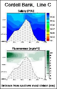
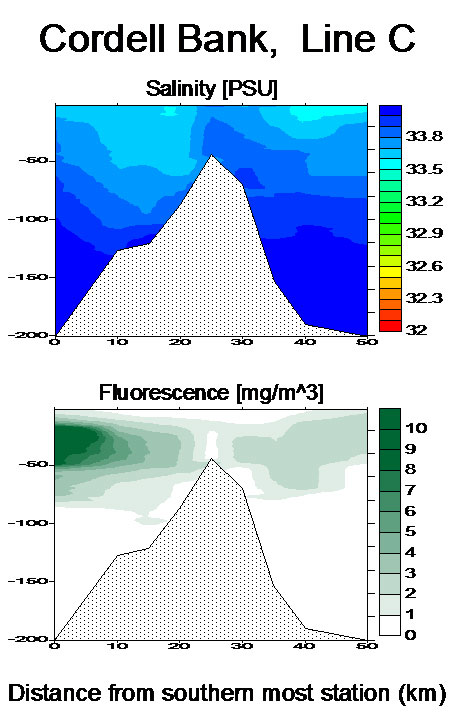
Localized upwelling over Cordell Bank
The top illustration is a cross section of the ocean over Cordell Bank. In the California Current, water flows in a southern direction, and as it reaches Cordell Bank (gray area), it finds an obstacle, forcing the water upwards. The deep saltier water in dark blue travels along the ocean bottom from the North (right side of diagram), and the Bank pushes the water upwards as it flows toward it, causing mixing at the top of Cordell Bank. This provides fertilizer for photosynthesis on the south side of Cordell Bank - as shown in the lower illustration in dark green.
 |
| Krill in tucker trawl capture. |
Krill, a tiny shrimp-like crustacean, is a keystone species in these waters. Virtually everything depends on it, from small fish to seabirds, to giant blue whales that eat almost nothing else. 2005 and to some extent 2006, have been low krill production years, resulting in massive seabird breeding failure and temporary but dramatic shifts in blue whale distribution. Since seabirds and mammals are indicators of the health of the ocean, one of the objectives of this research cruise is to determine how oceanographic and bathymetric features influence the abundance and distribution of krill and their marine predators within the sanctuary habitats. This research cruise is a collaboration between PRBO Conservation Science, and, Gulf of the Farallones and Cordell Bank National Marine Sanctuaries. These data are part of an on going study from PRBO funded by California Sea Grant to look at Krill and their predators in the region. For more information about Jahncke and his research, go to www.prbo.org.
Meet Professional Bird Observer and Field Biologist, Sophie Webb
What is a nice girl from Massachusetts going to do when she grows up? Our onboard ornithologist, Sophie Webb, spends most of her life out at sea studying and documenting birds in their natural habitats.
After studying art and graduating with a degree in biology, Webb donned her traveling shoes and has been studying marine wildlife and birds around the globe. You can find her conducting scientific research aboard ocean-going vessels such as the McArthur II, guiding trips in Antarctica as a naturalist aboard cruise ships or sketching birds in South America. Combining her talents and passions for wildlife and art, Webb has created award-winning field guides including A Guide to The Birds of Mexico and Central America, co-authored with Steve Howell; and children’s non-fiction books, Looking for Seabirds and My Season with Penguins. After this voyage, Webb will spend the next five months studying birds as part of the Equatorial Tropic Pacific study for Southwest Fisheries. With her expertise and keen eye, Webb is our primary wildlife observer responsible for identifying and counting birds along our designated transect lines. For more information about Webb and her work, see www.oikonos.org.
Our two principal investigators, Gulf of the Farallones Sanctuary Research Coordinator, Jan Roletto, and Senior Scientist at PRBO Conservation Science, Jaime Jahncke, guide us to our respective stations and brief us on our specific tasks, work schedules and daily routines.  | | L: GFNMS Research Coordinator, Jan Roletto. R: Senior Scientist at PRBO Conservation Science, Jaime Jahncke (Courtesy of Jamie Hall and GFNMS Photo Library). |
"The Day Begins at Night."
 |
| Deploying hoop net. (Photo: Jan Roletto) |
All our months of preparation have led us up to the first real research of our journey. On Monday, July 10, at 2000 hours (8pm), we truly set to work. As the sun disappears and the wildlife observers retire to their cabins, a full moon rises, and the night shifters begin to probe the column of dark water that flows beneath our hull, peering into the blackness with sophisticated sonar, the ER60, a "glorified fish-finder."
 |
| Hoop net in water. (Photo: Jamie Hall) |
We learn how to deploy various plankton nets (hoop net, Tucker trawl), and how to label the jars in which we will keep our specimens. Repeated net tows brought up krill, copepods, tiny crabs and other small creatures that migrate toward the surface at sunset.
We use a CTD instrument to record conductivity and temperature at varying depths to analyze the vertical profile of the water.
 |
| Scanning for wildlife from the flying bridge. (Photo: Jamie Hall) |
From dawn to dusk, we make ocean surface observations of seabirds and marine mammals from the flying bridge, the highest open vantage point on the ship. We document any seabirds, pinnipeds (seals and sea lions), sea otters, turtles, fish, jellies, any drift algae and marine debris found within 300 meters of our vessel. Also, we document any whales, dolphins and porpoises, and vessels within 800 meters of our ship. On deck, we utilize specialized data logging systems to record sightings and conditions and allow for nightly review of data.
|


