 | |||||||||||||||||||||||||||||||||||||||||||||||||||||||||||||||||||||||||||||||||||||||||||||||||||||||||||||||||||||||||||||||||||||||||||||||||||||||||||||||||||||||||||||
|
|
|
|
|
The following information summarizes an assessment, made by sanctuary staff and experts in the field, of the status and trends pertaining to water quality and its effects on the environment of the coastal and offshore zone in the Gulf of the Farallones sanctuary. 1. Are specific or multiple stressors, including changing oceanographic and atmospheric conditions, affecting water quality and how are they changing? Stressors on water quality in the nearshore environment, particularly impacts from oil pollution, sediment spills, and non-point source pollution from San Francisco Bay and the Russian River, may preclude full development of living resource assemblages and habitats, but are not likely to cause substantial or persistent declines. For this reason, the response to this question is rated "good/fair." The overall trend is considered to be "stable" because of a mix of improving conditions from some stressors and worsening conditions from other stressors.
According to NOAA Office of Law Enforcement case tracking software, illegal spillage and discharges from barges transporting dredge spoil-sediment across the sanctuary have also decreased. Increased compliance is, in large part, due to the discovery that a large dredging company had dumped dredged material from its disposal vessels into the Gulf of the Farallones over 200 times from 1999 through 2006. After settling with the U.S. Environmental Protection Agency and NOAA in 2006, the agencies have worked with the dredging company to improve monitoring systems and increase reporting requirements to minimize such violations (USEPA 2006). Populations of naturally occurring toxic algae occasionally grow to very high concentrations and produce extremely potent biotoxins. These events are termed harmful algal blooms. The California Department of Public Health and the State Water Resources Control Board's Preharvest Shellfish Protection and Marine Biotoxin Monitoring Program has found few harmful algal blooms within the Gulf of the Farallones region in recent years (although highest levels of amnesic shellfish poisoning were observed in the 1980s and can be expected to occur again). Increased development and urbanization in San Francisco Bay Area counties and within Sonoma County along the Russian River are of concern. There continue to be non-point source discharges of contaminants including persistent organic pollutants (e.g., DDT, PAHs, PCBs), pesticides, chemicals, heavy metals (e.g., nickel, cadmium) and sediments from outside sanctuary boundaries including San Francisco Bay, the Russian River, and Campbell Cove at the mouth of Bodega Harbor, but measurable impacts are not apparent (SFPUC 2006). Additionally, the state has listed two coastal beaches as impaired bodies of water on the 303(d) listing2, temporarily closing Muir Beach and Stinson-Bolinas Beaches due to high coliform counts and unsafe swimming conditions (see Table 2; SWRCB 2006). 2. What is the eutrophic condition of sanctuary waters and how is it changing? This response to this question is rated "good" because there are no known eutrophication problems in the offshore and nearshore zones of the sanctuary; therefore, conditions do not appear to have the potential to negatively affect living resources or habitat quality. In addition, the phytoplankton assemblage in the sanctuary is typical of surrounding coastal areas (G. Langlois, CA Dept. of Public Health, unpubl. data). However, a trend is "undetermined" with productivity largely affected by upwelling events (Falkowsi et al. 1998). Domoic acid, a potent neurotoxin that can cause neural damage, disorientation, short-term memory loss and even seizures and brain damage in vertebrates, has caused problems for seabirds and pinnipeds in other areas along the coast, primarily between Monterey Bay and Los Angeles. Despite this, domoic acid has not yet been the source of similar impacts within the Gulf of the Farallones sanctuary. However, the causative species - a diatom called Pseudo-nitzschia australis - has often been observed in sanctuary waters, and low levels of domoic acid have been detected in shellfish samples from the region by the California Department of Public Health (G. Langlois, CA Dept. of Public Health, unpubl. data). Furthermore, there have only been 15 years of monitoring for precursors of phytoplankton known to produce biotoxins. Since 2007, the sanctuary has been working with the California Department of Public Health to monitor the pelagic zones of the sanctuary for the biotoxin-producing phytoplankton Alexandrium catenella and P. australis. Recent work has shown that anthropogenic inputs of urea (a waste product of mammals, found in fertilizer and sewage systems) and possibly iron and copper (byproducts from agricultural runoff and dairy ranching) may promote the growth of biotoxin-producing phytoplankton (Armstrong et al. 2007, Scholin et al. 1999). 3. Do Sanctuary waters pose risks to human health and how are they changing?
Two localized stormwater-related beach closures at Stinson and Bolinas Beaches occurred in the past decade due to septic overflow. The state has listed Muir Beach as being an impaired body of water on its 303(d) listing (see Table 2; SWRCB 2006) due to concentrations of fecal indicator bacteria exceeding standards. These standards are also exceeded regularly at San Mateo County, Stinson, Bolinas and Bodega Harbor beaches. Hartwell (2007, 2008) notes that levels of contaminants including DDT, PAHs and PCBs are not deposited in sediment at alarming levels, but expressed concern that these pollutants may accumulate over time in the upper trophic levels (such as in large pelagic fishes that make up the commercial fishery), creating the potential for impacts to human health. While DDT, PAHs and PCBs are not accumulating in most regions of the sanctuary, there is some accumulation at depth relative to the shallower areas. A comparison of DDT, PAH, and PCB concentrations in sediment samples from the shelf, slope and submarine canyons between Point Reyes and the Big Sur coast found the highest levels in the canyons, including Pioneer and Bodega Canyons, and the lowest concentrations on the shelf (Hartwell 2008) (Figure 31). Normalizing data for total organic carbon content of the sediment shows where concentrations are elevated after adjusting for the affinity of the sediment to accumulate organic contaminants. For the PAH and PCB data, this procedure illustrates that the sediments in the Gulf of the Farallones appear to receive PAHs and PCBs from San Francisco Bay through tidal exchange through the Golden Gate and the offshore sewer outfall more than from longshore drift up the coast. The concentrations of contaminants are below National Status & Trends Sediment Quality Guidelines, but the nature of the chlorinated compounds will cause them to accumulate in the food chain at some level (Hartwell 2008).
Table 2. Impaired bodies of water in the sanctuary outer coast habitat as listed under the State 303(d) list. 303(d) lists are prepared as part of the Water Quality Assessment of the State's major water bodies, and meet a requirement of section 303(d) of the federal Clean Water Act. (SWRCB 2006).
4. What are the levels of human activities that may influence water quality and how are they changing?
The levels of human activities that influence water quality in the coastal and offshore areas of the sanctuary have resulted in measurable impacts to the ocean. However, although selected activities have resulted in measurable resource impacts, evidence suggests effects are localized and not widespread, and therefore the response to this question is rated as "fair." The levels of many human polluting activities are decreasing due to increased management and enforcement efforts since establishment of the sanctuary, thus, the trend rating is "improving." Vessel traffic in the sanctuary has grown over the past 10 years (Table 3), increasing the impact from noise, discharges of ballast and wastewater from cargo vessels and cruise ships, and the potential for large oil spills (HSCSFBR 2008). However, there has also been an increase in management and enforcement activities to help reduce the amount of acute and chronic oil pollution from sunken vessels and illegal discharges of oily bilge water, through increased regulatory actions and increased inspections of tank vessels by the state's Office of Spill Prevention and Response. In 2002, state and federal resource trustee agencies began the removal of oil and oil products from the sunken vessel S/S Jacob Luckenbach. Since the removal of over 60,000 gallons of oil, the sanctuary has detected a decrease in the number of oiled wildlife and tarballs along sanctuary outer coast beaches. Increased reporting and enforcement actions regarding illegal discharges of dredge spoil-sediment has also reduced impacts to the marine environment. Management efforts to implement best management practices to curtail non-point source pollution due to increased development and urbanization may also have helped show a decrease in pollutants in the coastal and offshore areas of the sanctuary. Increased urbanization and increased anthropogenic inputs of urea and possibly iron and copper may promote the growth of biotoxin-producing phytoplankton, thus increasing potential for paralytic shellfish poisoning and domoic acid toxicity (Armstrong et al. 2007, Scholin et al. 1999). Leaky septic tanks resulting from failing infrastructure at Muir and Stinson-Bolinas Beaches have led to closure of these beaches due to high coliform counts and unsafe swimming conditions (see Table 2 and Boehm 2009). But even with the increases in coastal use and urban areas along the coast, accumulation of non-point source pollutants have been seen only in the deeper regions of the sanctuary, Pioneer and Bodega Canyons. However, there is a concern that pollutants (DDT, PAHs and PCBs) may accumulate over time in commercial fish. Table 3. Vessel traffic in the sanctuary has increased from 1999 to 2008. "Tank" vessels carry oil as cargo and "Non-Tank" vessels are cargo vessels and barges that do not carry oil as cargo. (Source: HSCSFBR 2008).
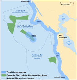
The following information summarizes an assessment, made by sanctuary staff and experts in the field, of the status and trends pertaining to the current state of the coastal and offshore habitat in the Gulf of the Farallones sanctuary. 5. What are the abundance and distribution of major habitat types and how are they changing? The abundance and distribution of major habitat types in the coastal and offshore zones of the sanctuary are rated "good/fair," as selected habitat loss or alteration has taken place, precluding full development of living resource assemblages, but it is unlikely to cause substantial or persistent degradation in living resources or water quality. The condition is rated as "improving," because although human population growth continues to have localized impacts, these may be offset by the recent reduction in trawling that impacts biologically structured habitats and the improved enforcement of dredge disposal practices. Sandy Shoreline In California, shorelines are naturally eroding, but this erosion rate may have increased because of an increase in storm intensity, sea level rise, and as a consequence of human activities that disrupt the natural sediment supply. A recent comprehensive analysis of long-term (over 100 years) and short-term changes (1950s-1970s vs. 1998-2002) in the abundance of sandy shoreline habitat in California found that the average net long-term shoreline change rate in the Central California region was undetectable, but the short-term average rate was strongly erosional (-0.5 m/yr) (Hapke et al. 2006). This shift to overall increased erosion in the more recent time period may be related to the climatic shift that began in the mid-1970s when California's climate entered a period of more frequent and stronger storms, including two of the most intense and damaging El Niño winters of the last century, during the winters of 1983-84 and 1997-98. Coastal armoring and coastal development projects continue to affect the sanctuary. Coastal armoring in the sanctuary has been prohibited since 1981 and thus limited to one beach on the outer coast and above the mean high tide. However, the maintenance of current armoring structures at Stinson Beach, which were placed in the sanctuary prior to 1981, and the development of new structures in order to reduce bluff erosion and protect buildings, particularly at Stinson Beach, has resulted in a narrowing and loss of sandy beach habitat (GFNMS 2008a). Road repair and maintenance has, at times, included coastal armoring and is thought to contribute to increased erosion and drainage problems in some of these areas. Though the cumulative impact of existing structures on the abundance and distribution of soft sediments in the sanctuary is not well understood, the localized impacts of armoring are better understood (Stamski 2005). Armoring alters the type of habitat in a given location, converting soft-sediment habitats (e.g., sandy beaches) to hard substrates such as rock, cement or steel, which support very different biological communities. The sanctuary monitors the erosion and deposition patterns along sandy shores through photo-documentation of the beach profile. Qualitative analysis of the beach profile images has not yet been done, but studies to examine the relationships between beach profiles, climate change and storm patterns are being planned.
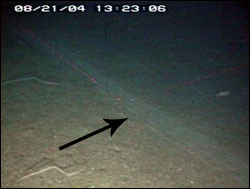
In general, the abundance of algae (e.g., red algal turf and rockweed) and surfgrass in the rocky intertidal habitat appears to be in good condition and currently stable, with the possible exception of areas with high levels of human visitation resulting in trampling of algae (Capitolo 2009, Tenera Environmental 2003, 2004). Studies of the impact of human visitation in the Point Piños area and the James V. Fitzgerald Marine Reserve (both in the Monterey Bay sanctuary) found that lower coverage of some types of algae in the upper intertidal zone and around the margins of tidepools may have been caused by chronic trampling from visitors (Tenera Environmental 2003, 2004). However, these studies also found that for the most part, areas with high visitation did not differ substantially from areas with low levels of visitation in the abundance and diversity of habitat-forming organisms. The rocky intertidal reef most visited in the sanctuary is Duxbury Reef, located in Marin County, and it is thought that visitation is increasing, although to what extent is unknown. Visitation is lower at Duxbury Reef than at the Point Piños area and the James V. Fitzgerald Marine Reserve, but Duxbury Reef is more easily accessible than other rocky intertidal areas in the Gulf of the Farallones sanctuary and it is still exposed to impacts from visitor use (Figure 32, Tenera Environmental 2004). The Sonoma County coast also contains some rocky intertidal sites; however, visitor information is not readily available for these areas. The sanctuary is currently evaluating the extent of trampling impacts at Duxbury Reef and developing outreach programs to minimize potential trampling impacts. Offshore Benthic Zone A number of studies have shown that mobile, bottom-contact fishing gear (e.g., trawl nets) can alter seafloor habitats and associated biota (NRC 2002). Mobile fishing gear reduces seafloor complexity through the removal of attached and emergent fauna that provide structure (e.g., corals and sponges), the removal of other sediment-associated megafauna that produce pits and burrows (e.g., crabs, fish), and the smoothing of bedforms (e.g., sand waves; Lindholm et al. 2004). In addition to the removal of targeted species, such operations can cause a variety of incidental biological impacts to non-targeted benthic organisms including changes in population densities, species diversity, community structure and composition, trophic structure, and productivity (Thrush and Dayton 2002). The impact from trawling and any recovery will vary depending on substrate and the associated community (NRC 2002). Data indicate that communities associated with hard substrates may require a decade or more to show any recovery (e.g., Collie et al. 2000), while other data suggest that recovery in soft-sediment communities may occur more rapidly depending on water depth (e.g., Lindholm et al. 2004, de Marignac et al. 2009).
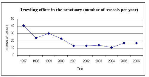
More than 47,000 barrels containing low levels of radioactive waste have been dumped into sanctuary waters (Karl 2001). This practice was ended in 1972, but the barrels remain (see Figures 23 and 24 in Pressures section). The barrels are in various states of deterioration, and debris fields have been side-scanned and mapped in the shallower areas of the dumpsites. Although only 10 percent of the radioactive waste dumpsite has been mapped, there is the possibility that the dumping of waste caused loss of habitat. Research results to date are inconclusive about the impacts on the marine habitats as a result of leakage from radioactive waste sites (Jones et al. 2001a). Tests have shown variable levels of radioactivity, and exploratory surveys using side-scan sonar and submersibles have found that the barrels are spread across the continental shelf and slope. Reference sites tens of nautical miles from the waste sites were sampled and were found to have background or less than background radioactive levels in both sediments and demersal fish tissue, indicating that in the early 1990s the impact of the shallower sites were not measurable on a large, regional scale. However, sediments directly within a radioactive waste site did contain elevated radiation levels. Benthic fish tissue from the waste site sampling location did not indicate elevated radioactivity levels; however, sampling problems and questions regarding methodology provide significant uncertainty (Karl 2001, Lindsay 1992, Suchanek 1988). Potential loss of benthic habitats is low to moderate in the areas of known barrel deposition, although actual impacts on abundance and distribution of habitat types are unknown. 6. What is the condition of biologically structured habitats and how is it changing? The condition of biologically structured habitats is rated "good/fair," as selected habitat loss or alteration has taken place, precluding full development of living resource assemblages, but it is unlikely to cause substantial or persistent degradation in living resources or water quality. Biologically structured habitat types in the coastal and offshore zones in the Gulf of the Farallones sanctuary include kelp, beach wrack, drift algae and fields of benthic invertebrates such as sea whips and sea pens. Kelp beds are not significantly abundant throughout the sanctuary and the beds that are present are seasonal. Accumulation of drift algae and beach wrack are considered to be a biologically structured habitat, because jellyfish, crustaceans and juvenile and larval fish live in the water column and within the drift algae (Reed et al. 1988, Shaffer et al. 1995, Vandendriessche et al. 2005, Laidig et al. 2007). The abundance, distribution and trends of beach wrack and drift algae are unknown. Sanctuary monitoring programs, including Beach Watch and Sanctuary Ecosystem Assessment Surveys-Pelagic Habitat (SEAS-PH), collect qualitative and quantitative data on the distribution and abundance of beach wrack and drift algae. Only a few years of SEAS data have been collected and beach wrack data have not been analyzed; therefore, the trend for this question has been rated as "undetermined."
7. What are the contaminant concentrations in sanctuary habitats and how are they changing? While there are no dramatic contaminant effects in the sanctuary (e.g., fish kills), data on contaminant concentrations are limited and it is difficult to determine a status for this question; therefore, the rating is "undetermined." There continue to be non-point source discharges of contaminants including persistent organic pollutants (e.g., DDT, PAHs, PCBs), chemicals, heavy metals (e.g., nickel, cadmium) and sediments from San Francisco Bay (SFPUC 2006). However, where there are data on contaminant concentrations in the coastal and offshore waters, it appears that concentrations are decreasing; therefore, the trend is rated as "improving." From the limited data sets that are available (Hartwell 2004, 2007, and 2008 and SFPUC 2006), the contaminant concentrations in the offshore zone are low, although there are elevated levels of PAHs and heavy metals, such as nickel and cadmium, at certain areas, accumulating primarily in the canyons to the south of the Gulf of the Farallones. Findings from Hartwell (2007) indicate that while persistent organic pollutants including DDT, PAHs and PCBs are not accumulating in the sediment in most regions of the sanctuary, there is some accumulation at depth in Bodega and Pioneer canyons relative to the shallower areas (this trend is consistent in depths greater than 1,000 meters) (I. Hartwell, NOAA, pers. comm.). Elevated concentrations are seen in fine-grained sediments at the heads and down the length of Monterey, Soquel, Ascension and Año Nuevo canyons (see Figure 31, Water Quality Question 3, in Coastal/Offshore section). Hartwell (2007, 2008) notes that levels of persistent organic pollutants including DDT, PAHs and PCBs are not deposited in sediment at alarming levels, but concerns exist that these pollutants may accumulate over time in the upper trophic levels, such as in large pelagic fishes that make up the commercial fishery. For example, Sydeman and Jarman (1998) found elevated levels of legacy pollutants (pollutants that remain in the environment long after they were first introduced) in Steller sea lions. The concentrations of contaminants in sediments are below National Status & Trends Sediment Quality Guidelines. In Monterey Bay, concentrations of the legacy pesticide DDT do not appear to be declining due to continuing watershed inputs (Hartwell 2004, 2007, 2008), but there are no trend data for the Gulf of the Farallones. Runoff from watersheds in agricultural areas, such as Monterey Bay, may influence the Gulf of the Farallones region as northward flows are common in winter, however, a tracer study would be necessary to evaluate the importance of this. 8. What are the levels of human activities that may influence habitat quality and how are they changing? The level of human activities in the coastal and offshore zone of the sanctuary is rated "good/fair" and "not changing" because some potentially harmful human activities exist, including shipping, increased urbanization and visitation, but they do not appear to have had a significant negative effect on habitat quality. Sandy beaches and rocky shores are primarily disturbed through human visitation and extraction. Impacts that result from visitation include: (i) trampling, modification, and subsequent loss of natural dune vegetation; (ii) spread of introduced species; (iii) grooming of sandy beaches resulting in the loss of habitat complexity; and (iv) littering of debris that unnaturally attracts scavengers and increases the potential for entanglement or ingestion of plastic debris. These impacts are expected to continue to increase as visitation rates are expected to increase (National Park Service Public Use Statistics Office, Annual Summary Reports). Increased urbanization could also contribute to increases in pollutants, but there are no obvious contaminant problems in the sanctuary and it appears that contaminant concentrations are decreasing in the coastal and offshore waters of the sanctuary. Vessel traffic has also increased (see Table 3, Water Quality Question 4 in Coastal/Offshore section), thus increasing the impacts from noise, dredging of shipping lanes, discharges of ballast and wastewater from cargo vessels and cruise ships (e.g., invasives), and increased potential for large oil spills (HSCSFBR 2008). However, there has also been an increase in management and enforcement activities to help reduce the amount of chronic oil pollution from sunken vessels and illegal discharges of oily bilge water. Trawling activity levels have also been reduced by recent area closures that should allow recovery of many of the impacted habitats located offshore (see Figure 34, Question 5). A recent study strongly suggests that there are impacts to sanctuary resources where trawling continues to occur, but that recovery is happening in areas where trawling has been curtailed (de Marignac et al. 2009). Roadside maintenance activities and coastal armoring placed prior to sanctuary designation continue to be localized problems that are clustered near population centers, such as near Stinson Beach and along sections of the coastal highway. Both activities can convert habitat type and increase erosion rates. Although these activities continue to occur in or adjacent to the sanctuary, they have not increased in intensity or frequency.
The following information summarizes an assessment, made by sanctuary staff and experts in the field, of the status and trends pertaining to the current state of the living resources found in the coastal and offshore environment of the Gulf of the Farallones sanctuary. 9. What is the status of biodiversity and how is it changing? The sanctuary has monitored species richness, density and percent coverage of rocky intertidal invertebrates and algae for the past 17 years. A rich and diverse ecosystem continues to exist on the Farallon Islands, with over 500 species found in the rocky intertidal communities, and a high level of layering and coverage (e.g., an average percent coverage of over 150% (Capitolo 2009)). Because of the rich and diverse rocky intertidal communities in the sanctuary, the status of biodiversity in the coastal and offshore zones of the sanctuary is rated as "good/fair" and "stable." Selected biodiversity loss has taken place, precluding full community development and function, but it is unlikely to cause substantial or persistent degradation of ecosystem integrity. Temporary or perhaps permanent changes in ecosystem structure have likely occurred. Changes in biomass within different trophic levels may have also occurred, but have not been tracked. It is unclear if there is a decline in zooplankton biomass in the Gulf of the Farallones region. There was a decline in overall copepod biomass in the mid 1970s, but community composition and diversity of copepods have not changed appreciably through time. Brinton and Townsend (2003) examined changes in euphausiid crustaceans (krill) and found that, aside from typical seasonal variations, there were no significant changes in the abundance of the two dominant species (Euphausia pacifica and Thysanoessa spinifera) within the larger California current system (British Columbia, Canada to Mexico). Studies of seabirds off California, part of the California Cooperative Oceanic Fisheries Investigations program (CalCOFI), indicate declines in the abundance of certain zooplankton-feeding species, notably shearwaters, which may be related to the change in zooplankton biomass and community structure described above (Veit et al. 1996, Hyrenbach and Veit 2003). Changes in oceanic conditions in recent years (Peterson et al. 2006, Goericke et al. 2007) have likely altered productivity within the sanctuary, with consequent changes in abundance and distribution of many taxa, including krill, fish, marine mammals and seabirds. Further, depletion of rockfish stocks due to overharvesting, as well as poor recruitment, has likely affected both species composition and reduced rockfish biomass in the sanctuary; however, recent stock assessments suggest that many populations of overfished species are increasing (PFMC 2006). In addition, the range expansion and recent addition of Humboldt squid to the marine ecosystem in this area could have a large impact on community structure, but there is not enough data at this time to formulate a trend or fully understand the impacts to ecosystem integrity. Shifts in the relative abundance of multiple species, especially those at higher trophic levels including marine mammals, are indicators of compromised native biodiversity in the system and can impact community and ecosystem structure and function. In combination, these natural and human-induced alterations have diminished, to some extent, ecosystem integrity in the sanctuary.
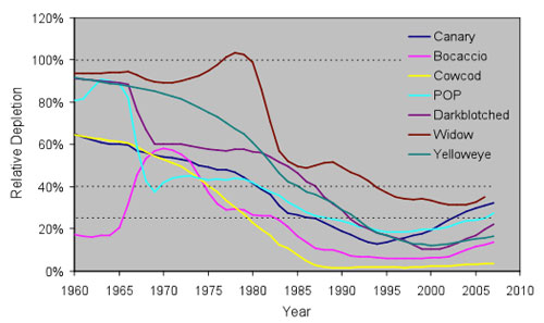
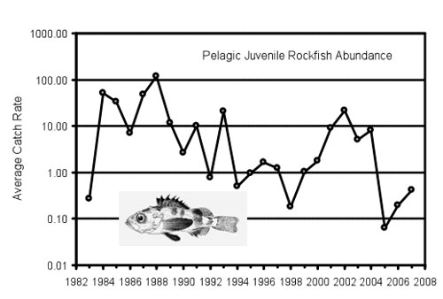
Overharvest of some rockfish populations (i.e. yelloweye, canary and cowcod), combined with poor recruitment, has severely impacted their populations along the West Coast (Ralston 2002) and has resulted in the closure of some groundfish fisheries in an attempt to rebuild depleted populations (Figure 37). There is also some indication that the general removal of large predators (e.g., yelloweye rockfish) can alter species composition, allowing populations of smaller fishes to expand, such as the pygmy rockfish (Sebastes wilsoni) and squarespot rockfish (S. hopkinsi) (Baskett et al. 2006). Closures associated with Rockfish Conservation Areas and Essential Fish Habitats have been established; these protected areas will locally reduce fishing pressure and help rebuild depleted rockfish populations (see Figure 34, Habitat Question 5 in Coastal/Offshore section). Population metrics from recent stock assessments indicate an increase in population abundance over the last five years for many overfished species, while populations of other species considered overfished appear to be stable (PFMC 2006). However, longer records are needed to determine if this is a trend due to improved management, rather than an environmentally induced fluctuation. Lingcod are a top predator and their population has been declared rebuilt after consecutive years of good recruitment (PFMC 2006). Nevertheless, pelagic juvenile rockfish surveys in 2005 within the Northern California region indicated an all-time low in catch (for a 23-year data set) (Figure 38) and an apparent shift in distribution of fish to the north and the south of the Central California region (Peterson et al. 2006, S. Ralston, NOAA NMFS Southwest Fisheries Science Center, unpubl. data). Finally, a combination of instream pressures such as water diversion, degraded spawning habitat and poor ocean conditions have taken a toll on populations of Chinook and coho salmon. Poor spawning escapement and record low numbers in the ocean elicited an unprecedented closure of the commercial and recreational fall run Chinook salmon fishery in 2008.
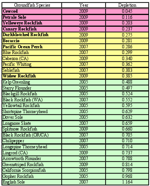
A decline in productivity of krill and fish may be associated with long-term variations in climate. Populations of some species, including Pacific sardine and northern anchovy, vary widely with decadal oscillations and climate fluctuations. Data indicate that sardine populations typically fluctuate between abundant and scarce over periods of 60 years, and somewhat in accordance with the Pacific Decadal Oscillation. Data also suggest that these species occupy similar ecological niches; as the sardine population increases, the northern anchovy population typically decreases (Takasuka et al. 2008, Chavez et al. 2003). As another example of linkages to climate variability, the entire shortbelly rockfish decline can only be attributed to natural environmental fluctuations (S. Ralston, NOAA NMFS Southwest Fisheries Science Center, pers. comm.). Only very minor landings of shortbelly rockfish have been reported in California over the last 20 years (10 - 70 mt/yr), amounting to less than 1 percent of the estimated optimum yield (13,900 mt/yr).4 Changes in fish and krill abundance can have cascading trophic effects on other species, including seabirds. For example, within the Gulf of the Farallones, Common Murres used to feed their chicks mostly juvenile shortbelly rockfish, but turned to anchovies and sardines after rockfish became scarce (Edgar 1997, Sydeman et al. 2001). As another example, local Cassin's Auklets did not breed in 2006 and had very poor breeding success in 2005 due to low productivity and severely reduced biomass of krill within the Gulf of the Farallones region (Abraham 2007). Abundance of non-resident species, such as Sooty Shearwaters and Black-footed Albatrosses, has also declined within the waters of Northern California (Ainley and Hyrenbach unpubl. data), potentially due to pressures from human impacts in their breeding areas. In addition, the Central California population of Marbled Murrelets, a seabird that forages in sanctuary waters and nests in old growth forests adjacent to the sanctuary, was recently estimated between 122 and 225 individuals, which represents a 54-55% decline since 2007 and 71-80% decline since 2003 (Peery et al. 2008). This decline is attributed in large part to terrestrial human activities that result in the degradation or loss of breeding habitat (Peery et al. 2008). Significant changes in abundance and distribution of sea otters, Steller sea lions and northern fur seals can be attributed to human activities including hunting that drove these populations in California to near extinction. All three taxa are carnivores that can have considerable influence on lower levels of the food chain, and their removal can greatly affect community structure. Pupping rates and general population health of Steller sea lions in California have decreased since the 1950s (Sease and Merrick 1997, Sydeman and Allen 1999). The breeding population at the Farallon Islands has stabilized in recent years, but remains depressed (Sydeman and Allen 1997 and 1999). Northern fur seals, extirpated from the Farallon Islands in the late 1800s, began breeding again on the Farallon Islands in 1996 (Pyle et al. 2001). Sea otters in particular are a well-documented keystone species that influence sea urchin populations and, in turn, kelp forest density (Kvitek and Oliver 1988). Historically, in the early 1800s otters were abundant in nearshore areas in the region of the sanctuary; however, they were nearly hunted to extinction. Following the otters' demise, the sea urchin population exploded, leading to severe reductions in kelp, and consequently significant biodiversity declines among species that depend on kelp habitats (Kvitek and Oliver 1988). However, the commercial sea urchin fishery has mitigated the absence of sea otters and subsequently has prevented continued reductions in kelp on the north and north-central coast (P. Reilly, CA DFG, pers. comm.) The protection and active management of marine mammal populations by state, federal and international entities has allowed the recovery to some extent of sea otter, Steller sea lion and northern fur seal populations, and these species could regain a measure of control in the ecosystem over the resources that support them. 10. What is the status of environmentally sustainable fishing and how is it changing? The status and trend ratings for this question are based on the available scientific knowledge (e.g., published studies, unpublished data and expert opinion) of targeted and non-targeted living resources that are directly and indirectly affected by fishing. Due to historical fishing impacts and recent regulatory actions to restore some fish populations, the status of sustainable fishing is rated "fair" and the trend is "improving." Experts speculate that fishing activities may inhibit full community development and function, and may cause measurable but not severe degradation of ecosystem integrity. Because this is the first sanctuary condition report, the rating reflects a more historical view of the potential effects of fishing activity on biological community development, function and ecosystem integrity over the last two to three decades. Subsequent reports will take a more contemporary view of the ecosystem-level impacts of fishing. The rating does not serve as an assessment of the status of current fisheries management practices in the region. However, the determination of an increasing trend for this question does reflect recent changes in fisheries management practices and their positive effects on living resources in the sanctuary. For this report, environmentally sustainable fishing or ecologically sustainable fishing is defined as fishing at a level that the ecosystem can sustain without shifting to an alternative or undesirable state. To determine if environmentally sustainable fishing is occurring, one has to simultaneously consider the impacts of all harvested species on an ecosystem, and community stability and resilience (Zabel et al. 2003). Environmentally sustainable fishing is designed to consider fishery yield and the integrity of ecosystem structure, productivity, and function and biodiversity, including habitat and associated biological communities. Recent amendments to the Magnuson-Stevens Act have prescribed a more holistic consideration of sustaining fisheries by stipulating that yields from a fishery must take into account the protection of marine ecosystems (NMFS 2007). In the late 1970s and 1980s there was a significant gillnet fishery in the nearshore areas of Central California targeting California halibut (Paralichthys californicus) and soupfin shark (Galeorhinus galeus). Harvest levels were substantial for a short period of time and by-catch levels were high. However, management regimes for commercial fishing are currently more risk-averse than in prior decades, and some measures are proving successful in allowing over-fished stocks to recover. Trawling for spot prawns was prohibited in 2003 in Central California. Bottom trawling was prohibited in all state waters in 2005, with the exception of the halibut trawl grounds in Southern California. The number of active trawlers in the region has declined as prohibitions, quotas and gear restrictions have made it less profitable to trawl. In 2006, there were six commercial fisheries (Dungeness crab (Metacarcinus magister), California halibut (Paralichthys californicus), Chinook salmon (Oncorhynchus tshawytscha), Pacific herring (Clupea pallasii), sablefish (Anoplopoma fimbria) and petrale sole (Eopsetta jordani)), each with over $100,000 in annual landings value in the ports of San Francisco and/or Half Moon Bay (P. Reilly, CA DFG, pers. comm.). Recreational fishing primarily targets rockfish species, lingcod (Ophiodon elongates), California halibut, striped bass (Morone saxatilis), salmon species, albacore (Thunnus alalunga), surfperch species and Dungeness crab. A recreational fishery for Humboldt squid (Dosidicus gigas) has begun, but the levels of take and impacts from the recreational take of squid have not yet been assessed. The California Recreational Fisheries Survey provides the best estimates available on recreational catch of finfish by geographical area. Overall, recreational fishing effort appears to have stabilized for at least two reasons: fishing regulations have become more restrictive by depth and season, and some bag limits have been reduced in the past decade. Commercial passenger fishing vessels (party boats) have responded to increased interest in ecotourism by directing more effort toward whale watching, seabird and shark ecotourism trips. Gillnetting can impact other living resources. For example, since the late 1970s, Common Murres declined 50 percent in Central California. Some populations were even depleted or extirpated, partly due to gillnetting, oil pollution and environmental factors (Manuwal et al. 2001). Sea otters were also impacted by gillnets, as were harbor porpoises during the 1970s and 1980s (Forney 1999, Carretta et al. 2005a). The gillnet fishery was severely restricted in 1989 in the Gulf of the Farallones and a few years later in Monterey Bay (NMFS 1999). In the past, there was significant depletion of certain rockfish populations in the Gulf of the Farallones. The National Marine Fisheries Service conducts an annual survey to estimate the distribution and abundance of pelagic juvenile rockfish in the immediate region of the sanctuary (see Figure 38, Question 9). Results show that during the late 1980s catches averaged 10 to 100 fish per trawl, but during the 1990s there was a general decline in abundance, falling to 0.2 fish per trawl in 1998. In the early 2000s, seven species of rockfish (bocaccio, cowcod, widow, yelloweye, canary, darkblotched and Pacific ocean perch) were formally declared overfished throughout their range by the National Marine Fisheries Service; all but the latter species are relatively common within the sanctuary (see Figure 37, Question 9). Subsequently catches increased to around 10 fish per trawl from 2001 to 2004, but dropped abruptly to the lowest value in the time series in 2005 (0.1 fish per trawl). Since then, catches have increased slightly, but still remain low (0.4 fish per trawl in 2007). Trends in abundance of exploited and unexploited species are very similar, implying that variation in the environment is largely responsible for these trends (S. Ralston, NOAA NMFS Southwest Fisheries Science Center, unpubl. data). Preliminary trends indicated that there are increasing numbers of groundfish (S. Ralston, NOAA NMFS Southwest Fisheries Science Center, unpubl. data). Future Gulf of the Farallones sanctuary Condition Reports will reflect these latest trends. Fishing for rockfish is prohibited within the Rockfish Conservation Areas, established in 2002. Rockfish Conservation Areas are modified annually and can vary by season, depth and fishing gear types. Recovery of overfished species is expected to take some time due to their slow maturity rates. Lingcod was previously declared overfished but has now recovered (PFMC 2006) after harvest restrictions proved successful, as the rapid growth and maturity of this species resulted in more rapid population increases than the overfished rockfish species. The prohibition of bottom trawling in state waters in 2005 and Essential Fish Habitat designations in 2006 in some offshore areas are expected to increase habitat protection (see Figure 34, Habitat Question 5 in Coastal/Offshore section). Of the 30 groundfish species stocks, four species stocks (cowcod, petrale sole, yelloweye rockfish and canary rockfish) are at or below the minimum stock size threshold for overfishing, which is 25 percent or less. Eighteen species stocks are considered not depleted by the Pacific Fisheries Management Council (Table 4). Table 4.
At one time, five species of abalone (red, pink, green, black and white) supported recreational and commercial fisheries in California. Of these five species, only red and black (Haliotis rufescens and H. cracherodii) occur in any abundance within the sanctuary (Leet et al 2001). By 1997, Central and Southern California abalone had experienced stock collapse from both natural and human-related causes, resulting in the closure of all commercial abalone fishing in those areas. The only abalone fishery currently open in the state is the red abalone sport fishery in the Northern California region, from Marin County northward. The five formerly fished species in the central and Southern California regions are at risk of further population declines and white abalone are near extinction. In 2009, the black abalone was listed as an endangered species under the federal Endangered Species Act (NMFS 2009). 11. What is the status of non-indigenous species and how is it changing? Non-indigenous species are not suspected or do not appear to affect ecosystem integrity (full community development and function) in the sanctuary; therefore, the response to this question is rated "good" and the trend is "not changing." Non-indigenous planktonic species (e.g. copepods Oithona davisae and possibly Pseudodiaptomus marinus) do occur in offshore waters, but little assessment or monitoring of their occurrence or impacts has been conducted (pers. comm. W. Kimmerer, San Francisoc State University). Of what little is known about non-indigenous planktonic species, there are no apparent ecosystem impacts. Striped bass occur offshore, but are very rare overall. Nonetheless, there is concern about the potential impacts of striped bass on tidewater gobies, salmon and anchovies, but results are not conclusive. It is unlikely that striped bass impact salmon offshore to any significant extent (S. Bennett, NMFS, pers. comm.). European green crabs (Carcinus maenas) are a threat in nearshore environments. They can prey on and compete for resources with native crabs, such as Dungeness crabs, and as such may have profound impacts on the commercial fishery (Cohen 1997). The sanctuary has limited data on non-indigenous species in the rocky intertidal habitats - data sets are available from the Farallon Islands and the mainland, dating from the 1990s. A species inventory suggests that some non-indigenous algal species (e.g., Sargassum muticum and Codium fragile tomentosoides) do occur in the rocky intertidal habitats of sanctuary, but the extent and impacts are not known. 12. What is the status of key species and how is it changing? Changes in oceanic conditions in recent years have altered productivity within the sanctuary, with changes in abundance and distribution of many taxa, including indicator species such as krill, fish, marine mammals (Carretta et al. 2005b) and seabirds (Ainley et al. 1993, Miller and Sydeman 2004). Furthermore, depletion of rockfish stocks due to overharvesting, and poor recruitment is suspected to have caused an overall decline in the rockfish biomass and altered species composition in the sanctuary (PFMC 2006), although stock assessments suggest that many populations of overfished species are increasing (S. Ralston, NOAA NMFS Southwest Fisheries Science Center, unpubl. data). Several of the indicator species appear to have been negatively impacted by the combination of natural and human-caused forces, such as overfishing during El Niño conditions (Baskett et al. 2006). Substantial or persistent declines, however, are not expected for most of these species, and several of the indicator species that feed within the sanctuary exhibit healthy populations that are increasing. Because selected key species are at reduced levels but recovery is possible, the status of key species is rated "fair." However, because there is considerable variability in trends for these species, an overall trend has been rated as "undetermined." The staff of the Gulf of the Farallones sanctuary has identified 49 species that are considered to be key species (Table 5). Some of the species were selected because they are keystone species, while others were selected for their value in monitoring (e.g., significance in the food web or have a special management/regulatory status), their susceptibility to acute events such as oil spills, or because they are charismatic or iconic. Table 5
The status of the 49 species varies significantly, and while it can be confidently stated that the reduced abundance of certain species, such as rockfish, sea palms, sea turtles, abalone, etc., has altered the ecosystem to some extent, the overall trend is unclear. Some species are clearly in decline, while others have been increasing in abundance over recent years (e.g., humpback and gray whales, coralline algae, fur seals, Common Murres and several other species of seabirds). The following section focuses on a few examples from each of the major groups. Rocky Intertidal Species: Large-scale climate and oceanographic changes also influence the composition, abundance and distribution of intertidal organisms. Shifts in the composition of the Central California rocky intertidal zone may be attributed to climate changes in recent decades (Barry et al. 1995, Sagarin et al. 1999, Pearse 1998). Sanctuary staff continues to monitor abundance and range extensions for species in the rocky intertidal habitat (Helmuth et al. 2002, Airamé et al. 2003). Sardine and Northern Anchovy: Populations of some species, including the Pacific sardine and northern anchovy, vary widely with climate fluctuations. Data indicate that sardine populations typically fluctuate between abundant and scarce over periods of 60 years, and somewhat in accordance with the Pacific Decadal Oscillation. After a collapse of the sardine fishery in the 1950s, northern anchovy populations increased dramatically, suggesting that these species occupy similar ecological niches. As large populations of sardines reappeared in the early 1970s, the northern anchovy population declined steadily (Takasuka et al. 2008, Chavez et al. 2003, Airamé et al. 2003). Rockfish: Rockfish are one of the most ecologically important species groups in the sanctuary, and status varies by species. In the early 2000s, seven species of rockfish - widow (Sebastes entomelas), yelloweye (S. ruberrimus), canary (S. pinniger), darkblotched (S. crameri), bocaccio (S. paucispinis), cowcod (S. levis) and Pacific ocean perch (S. alutus) - were formally declared overfished throughout their range by the NOAA National Marine Fisheries Service. Population metrics from recent stock assessments indicate an increase in abundance over the last five years for many overfished species, while populations of other species considered overfished appear to be stable (PFMC 2006; see Figure 37, Question 9). Nevertheless, pelagic juvenile rockfish surveys in 2005 within the Central and Northern California region (Carmel to Bodega Bay) indicated an all-time low in catch (for a 23-year data set) (see Figure 38, Question 9) and an apparent shift in distribution of fish both to the north and the south of the Central California region (Peterson et al. 2006). There is also some indication that the general removal of large predators such as yelloweye rockfish can alter species composition, allowing populations of smaller fishes such as pygmy and squarespot rockfish to increase (Baskett et al. 2006). Leatherback Turtle: Since 1980, the population of leatherback sea turtles in the Pacific Ocean has declined by 95 percent (Benson et al. 2007). Leatherback sea turtles are killed accidentally during gillnet and longline fishing activities, many are hunted for food on their breeding beaches in the Western South Pacific, and they may also die when they ingest marine debris. The status and trend of leatherback turtle populations in the Gulf of the Farallones region are poorly understood. Preliminary findings from the sanctuary's monitoring programs and other researchers indicate that although turtles are not common throughout the year they are seen in sanctuary waters during the summer and fall months (Benson et al. 2007). Marine Mammals: Numerous factors have contributed to historical declines of marine mammals, and some continue to affect populations. Though marine mammals were fully protected from hunting in 1972 with the passage of the Marine Mammal Protection Act, some are killed incidentally by entanglement in fishing gear, particularly set and drift gillnets. Restrictions on these fisheries have reduced the rate of entanglement, but some animals are injured or killed each year during routine fishing operations when they become caught in marine debris. The Steller sea lion population has declined over the last 30 years, in part due to a decline in sardine populations (which have since rebounded), entanglement in fishing gear, deliberate culling of the sea lions to protect salmon and herring fisheries and for dressings (genital parts), and possibly disruption of reproductive capabilities owing to chemical pollution (Sydeman and Jarman 1998). The Steller sea lion population in California is listed as a state and federally threatened species. The breeding population at the Farallon Islands has stabilized in recent years, but remains depressed (Sydeman and Allen 1997). Blue, humpback and fin whales were hunted to near extinction during the last two centuries. These species are recovering under international protection; however, all three are currently listed as endangered. Seabirds: Many bird species in the sanctuary have declined during the last 150 years due to egg collection on the Farallon Islands, fishing techniques such as gillnetting in waters less than 60 meters, and disturbance by other human activities such as close approach by boats, low-flying aircraft and people on foot (Rojek et al. 2007 and Leet et al. 2001). However, some of the pressures were reduced when the Farallon Islands became a national wildlife refuge in 1969, and when Gulf of the Farallones National Marine Sanctuary was established in 1981. Under protection, many seabird populations have increased or recovered (Luckenbach Trustee Council 2006). However, unusually high mortality of Common Murres from November 1997 to March 1998 was associated with oil spilled from the S/S Jacob Luckenbach, and chronic oil pollution by illegal discharges from vessels is still a major concern. Typically, 30 to 90 percent of seabirds killed in moderate to large oil spills in the Gulf of the Farallones are Common Murres (Roletto et al. 2003). Incidentally, Common Murres appear to be improving as threats from gillnets and chronic spills have been reduced (Manuwal et al. 2001). On the contrary, Cassin's Auklets have been declining over the last few decades (Abraham 2007). This may be related to declines in krill, which are heavily influenced by environmental factors. Birds that prey on juvenile rockfish (e.g., Pelagic Cormorant, Pigeon Guillemot) have also been undergoing long-term declines as a result of decreased rockfish stocks (Sydeman et al. 2001). As rockfish recover following fishing restrictions, this trend could reverse. Sooty Shearwaters, which consume small schooling fish, squid and zooplankton in the North Pacific from March through November, have exhibited a dramatic decline in abundance in the waters of the California Current (BirdLife International 2009, Veit et al. 1996). The decline in productivity of the California Current system may be associated with long-term variation in climate. Other factors can also affect the recovery potential for many species, particularly among birds. These include increasing nest disturbance, oil pollution and marine debris. Small pieces of plastic among marine debris are an increasing concern, because plastic is slow to break down in the environment. Birds ingest plastic, mistaking it as a food item. Plastic can be deadly for birds and their chicks, clogging their digestive tract and eventually causing starvation. 13. What is the condition or health of key species and how is it changing? The condition of selected key resources is not optimal, perhaps precluding full ecological function, but substantial or persistent declines are not expected. Therefore, with a few exceptions, the health of key species in the offshore and coastal zone of the sanctuary is rated "good/fair" and the overall trend is "improving." Pinnipeds and seabirds are vulnerable to accumulation of toxins such as organochlorines and domoic acid (the latter is a potent neurotoxin produced during harmful algal blooms that can cause neural damage, disorientation, short-term memory loss and even seizures and brain damage in vertebrates). These toxins are filtered from the water by plankton and various filter-feeding invertebrates, from which point they move up the food chain and become concentrated in organisms such as marine mammals and seabirds. In the offshore zone, domoic acid events have not been documented in the Gulf of the Farallones region, and many animals whose condition changes with time appear to be responding to natural environmental variation (e.g., oceanographic changes that seasonally affect krill abundance, and changes in prey abundance that affect fecundity and juvenile survival rates of seabirds and salmon health). There are some resources in the sanctuary that do not appear to be in optimal condition. Recent observations of gray whales in their breeding areas suggest declining weights may be due to poor food conditions and climatic changes influencing ice cover in the Bearing Sea, or the population has attained maximum carrying capacity (Moore et al. 2001, Perryman et al. 2002). Pupping rates and general population health of Steller sea lions in California have decreased since the 1950s. The breeding population at the Farallon Islands has stabilized in recent years, but remains depressed (Sydeman and Allen 1997). Other key resources do not seem to be in diminished condition. This may be attributable, in part, to management actions that have reduced oil pollution from chronic sources (e.g., illegal discharges and leaks from sunken vessels) and from acute sources (moderate to large oil spills) since designation of the sanctuary in 1981 (see Figure 29, Water Quality Question 1 in Coastal/Offshore section). These management actions have been followed by a stabilization or increase of some marine mammals (elephant seals and other seals), and an apparent improvement in seabird populations in the sanctuary. For example, the number of oiled, beached seabirds in the sanctuary has decreased since the removal of oil from the sunken ship S/S Jacob Luckenbach, which in the past had negatively affected the health of seabirds and marine mammals (Roletto et al. 2003, FMSA 2006). Nevertheless, oil from chronic, illegal discharges continues to impact 2 to 8 percent of seabirds within the Gulf of the Farallones region (Roletto et al. 2003). 14. What are the levels of human activities that may influence living resource quality and how are they changing? Selected activities have resulted in measurable living resource impacts, but evidence suggests effects are localized, not widespread. Therefore, the level of human activities impacting living resources in the offshore and coastal zone of the sanctuary is rated "fair" and the overall trend is "not changing." While numerous human activities in the offshore and coastal areas of the Gulf of the Farallones sanctuary are known to affect marine resources, overall the levels of activities appear to be fairly stable. Continued human population increases, urbanization and increased use of coastal areas and resources are known to affect living resources. For example, in California many intertidal invertebrates, including crabs, snails, mussels, barnacles and some seaweeds, are harvested for commercial and recreational use. Studies of the intertidal zone have also detected changes in density and species composition resulting from trampling (Van De Werfhorts and Pearse 2007). Trampled communities can be slow to recover. For example, recovery of fast-growing algal and small invertebrate species can take one to three years, while larger invertebrate species or annual algal species may take seven to 15 years (Tenera Environmental 2003, 2004). Human trampling has also been shown to have a major effect on reducing the cover of mussels and rockweeds, increasing the proportion of bare rock (Van De Werfhorts and Pearse 2007). Compounding impacts, such as trampling, extraction, environmental changes in ocean temperatures, and oil pollution, can cause large swings in density and recovery for some species. For example, after the Exxon Valdez oil spill, the intertidal algae Fucus sp. recovered, increasing in density for five to seven years after shoreline treatments. After seven years, density greatly dropped due to senescence of aging plants (Coats et al. 1999). The sanctuary is monitoring for recovery after oil spills at two highly visited rocky reefs, Duxbury Reef in the Gulf of the Farallones sanctuary and Fitzgerald Marine Reserve in the northern portion of the Monterey Bay sanctuary. Preliminary data suggest an initial increase in Fucus sp. after the Cape Mohican oil spill. Detection of recovery has been complicated by several subsequent spills, the most recent being the Cosco Busan spill in 2007. Seabird species like the Common Murre that nest or roost on cliffs or offshore rocks, areas that have been historically inaccessible to most land predators, are now highly susceptible to human disturbances. Monitoring efforts at colonies within and adjacent to the sanctuary have shown that low-flying aircraft, boats, and humans on foot have all impacted seabird breeding and roosting activities (Rojek et al. 2007). These disturbances are currently stable or increasing at certain colonies. Increased shipping (see Table 3, Water Quality Question 4 in Coastal/Offshore section) has resulted in an increase in flushing of waste and ballast water from vessels. Disturbance to seabirds and marine mammals by vessel noise is also likely to be on the rise, though no recent data exist for comparison. However, vessel strikes of whales do not appear to be increasing within the Gulf of the Farallones region (Jensen and Silber 2003). The effects of lights from squid fishing boats have been eliminated, since the use of squid-attracting lights has been banned within the sanctuary by the state of California. The trend of the effects of spotlights and deck lights from crab fishing boats is not known. The frequency of illegal discharges (e.g., dredged material and oily bilge water) is probably remaining stable. Over the past 10 years, there has been an increase in the popularity of tourism vessels venturing to the Farallon Islands to view white shark activity during the fall. Trawling is decreasing due to harvest and area restrictions, attrition, and higher operating costs. Oil spills are one of the key threats to birds and marine mammals, and have been reduced in part due to the removal of leaking oil from the sunken vessel S/S Jacob Luckenbach. Management and regulatory actions have been implemented to address declines in various living resource populations. For example, the establishment of restrictive commercial and sport fishing regulations and the establishment of Essential Fish Habitats by state and federal fisheries agencies has, in many cases, allowed for some recovery (e.g., rockfish species). At one time, five species of abalone supported recreational and commercial fisheries in California. However, by 1997 abalone had experienced stock collapse from both natural and human-related causes, resulting in the closure of all abalone fishing south of Marin County. The black abalone population was the most recent to collapse, and in March 2009 it was added to the Endangered Species List. The only abalone fishery currently open in the state is the red abalone sport fishery in the Northern California region, from Marin County northward. Some commercial and passenger fishing vessels (e.g., party boats) have responded to increased regulatory actions by converting to ecotourism, directing more effort toward whale and other marine animal watching. Seabirds and marine mammals have also benefited from the establishment of national marine sanctuaries (Calambokidis et al. 2001) and national wildlife refuges (Ainley et al. 1977).
The following information summarizes an assessment, made by sanctuary staff and experts in the field, of the status and trends pertaining to the current state of maritime archaeological resources in the coastal and offshore zone in the Gulf of the Farallones sanctuary. 15. What is the integrity of known maritime archaeological resources and how is it changing? Little is known about all of the cultural resources of the sanctuary, so there is uncertainty about the integrity of submerged maritime archaeological resources in the offshore environment. Therefore, the response to this question is rated as "undetermined." The sanctuary's inventory contains information on known vessel losses, with little to no verified location information, and few visited sites. To date, only one offshore non-archaeological site location assessment has been conducted in the sanctuary by Titan Maritime Inc. (S/S Jacob Luckenbach in 2002). No other offshore site evaluations have been conducted by other federal, state or private resource management agencies. Although anecdotal information is available, there is no baseline monitoring information available to detect a change or impact to the resources; therefore, a trend is also "undetermined." Some archaeological sites are regularly visited by divers and beachcombers, and in some cases artifacts have been removed from accessible sites like the Gold Rush-era passenger steamer S/S Lewis, lost in 1853, which is now on display at the San Francisco Maritime National Historical Park's Visitors Center and Interactive Museum (Schwemmer 2006). It is assumed there is less relic hunting occurring today due to education, and most of the accessible sites have already been pilfered. Yet some of the less impacted sites are becoming well-known due to an increase in information exchange among enthusiasts. Recreational divers have located at least nine shipwrecks in the Gulf of the Farallones sanctuary. Most of these nearshore sites are in less than 100 feet (30 meters) of water and are reported in various stages of degradation due to their close proximity to shore. Sites in shallow-water environments within higher energy zones are more likely to be subjected to degradation by waves, shifting sands and strong currents. Submerged cultural material associated with Native American terrestrial sites is likely to be exposed in the nearshore environment as a result of coastal land erosion (Terrell 2007). The high level of uncertainty surrounding offshore wreck sites is primarily because the majority of sites have not been visited or investigated. Sites in deep water are assumed to be in better condition than those in shallow water, because they are not impacted by strong currents and the cold, deepwater environment tends to have fewer biological processes accelerating ship degradation. One probable impact in offshore waters is from bottom trawling, but the majority of wreck locations are unknown, so the impacts from historical and recent trawling are therefore unknown. However, some archaeological documentation exists of submerged maritime archaeological resources in the coastal environment of the sanctuary. To date, a few archaeological surveys have been conducted in the nearshore environment of the sanctuary. The National Park Service surveyed the steam-schooner Pomo, lost in 1913, the cargo steamer Hartwood, lost in 1929, and the cargo steamer Munleon, lost in 1931 (Murphy 1984). Remote sensing surveys have been conducted by the National Park Service, working in collaboration with the California State Lands Commission and the sanctuary, in an effort to locate the remains of the Spanish Manila-galleon San Agustin, lost in 1595. No other complete site surveys have been conducted by other federal, state or private resource management agencies in the nearshore environment. 16. Do maritime heritage resources pose an environmental hazard and is this threat changing? Gulf of the Farallones National Marine Sanctuary's inventory of known maritime archaeological resources suggests there are shipwrecks offshore that have the potential to pose an environmental hazard to sanctuary resources due to deterioration that would result in the release of hazardous cargo or bunker fuel. Examples include the U.S. Navy aircraft carrier USS Independence, scuttled in 1951, the C-3 Freighter S/S Jacob Luckenbach, lost in 1953, and partial remains of the tanker Puerto Rican, lost in 1984. After military service, the USS Independence became a target vessel for the Bikini Atoll atomic bomb tests known as Operation Crossroads in 1946. The ship was positioned within one-half mile of ground zero for the July 1 explosion, but the Independence did not sink. She took part in another explosion on July 25, then was taken to Kwajalein Atoll (part of the Republic of the Marshall Islands) to be decommissioned. The highly radioactive hulk was later taken to San Francisco via Pearl Harbor for further tests and was finally sunk in weapons tests off the Farallon Islands on Jan. 27, 1951. After sand blasting the hulk, the radioactive sand and protective clothing was put into 55 gallons drums and sunk with the ship. It is unknown whether other contaminants or munitions were sunk with the ship. The Puerto Rican, with a cargo of 91,984 barrels of lubrication oil and additives, took on 8,500 barrels of bunker fuel departing from San Francisco for New Orleans on Oct. 31, 1984. An explosion occurred that day which blew flames several hundred feet into the air, knocking the pilot and two crew members into the water. The U.S. Coast Guard responded, and the burning tanker was towed to sea in order to minimize the chance of a disastrous oil spill in the sensitive areas of San Francisco Bay, the adjacent ocean shoreline, and the sanctuary. The fires were extinguished the following afternoon but the tanker, with her hull weakened by fire and the explosion, broke in two sections on Nov. 3, releasing 30,000 barrels of oil into the water. The stern section, containing 8,500 barrels of fuel oil, sank within in the boundaries of the sanctuary (Delgado and Haller 1989).
Based on the sanctuary's inventory of known maritime archaeological resources in shallow water (50 feet or less), it is unlikely that the remains of shipwrecks in the coastal environment hold hazardous cargos or bunker fuels. This is also true for shipwrecks located near the entrance to San Francisco Bay (just beyond the sanctuary boundary) that were either dynamited as a hazard to navigation or were part of the city of San Francisco's efforts to clear wrecks above the waterline that were considered unsightly. 17. What are the levels of human activities that may influence maritime archaeological resource quality and how are they changing? It is probable that bottom trawling is impacting resources, and archaeological resources are permanently damaged once trawling impacts a site. However, the numbers of trawlers and areas available to trawling have decreased recently due to management regulations. Therefore, some potentially relevant activities exist, but they do not appear to have had a negative effect on maritime archaeological resource integrity, and this question is rated "good/fair." With the recent trawl closures in state waters, the shift of fishing effort offshore may increase risk to resources that have not been impacted in the past. Because the majority of wreck locations are unknown, the trend of the impacts from historical and recent trawling is "undetermined." The development of underwater technologies now affords the public the opportunity to locate and visit deepwater archaeological resources in the offshore environment. The diving community must be educated on the regulations in place in order to protect these non-renewable resources. Archaeological resources in deeper and calmer offshore waters are generally in a more stable environment, limiting physical impacts. Cold, deepwater environments tend to have fewer biological processes accelerating ship degradation compared to nearshore sites. The laying of new submerged cables is no longer a threat to archeological resources within the sanctuary due to strong regulations prohibiting disturbance of the seabed or the marine archeological resources. Several human activities may influence the quality of maritime archeological resources in the coastal environment, including the removal of artifacts from archeological sites, diving, anchoring and fishing activities (e.g., trawling, other gear impacts). Bottom trawling is currently prohibited in California state waters, but historically, trawling may have impacted resources. Local museums and historical societies exhibit artifacts that were removed from archaeological resources prior to the establishment of Gulf of the Farallones National Marine Sanctuary. Site looting (where objects are intentionally pilfered from submerged sites) may pose a major threat to submerged archaeological resources. Divers visiting sites may cause injury through poor diving techniques, inadvertently holding onto fragile artifacts or striking them with scuba tanks. Vessel activity, such as anchor drags or modern ship groundings, can also cause serious injury to submerged archaeological resources. These potential impacts have not been measured, but for the known archeological sites, current human activities do not appear to have a significant negative impact on the integrity of these resources.
. . . . . . . . . . . . . . . . Error processing SSI file |
|
||||||||||||||||||||||||||||||||||||||||||||||||||||||||||||||||||||||||||||||||||||||||||||||||||||||||||||||||||||||||||||||||||||||||||||||||||||||||||||||||||||||||
|
|||||||||||||||||||||||||||||||||||||||||||||||||||||||||||||||||||||||||||||||||||||||||||||||||||||||||||||||||||||||||||||||||||||||||||||||||||||||||||||||||||||||||||||