Maritime Cultural Landscapes
Archival Resources
T-Sheet Maps
When the Survey of the Coast began its fieldwork around "New York Bay and Harbor and the Environs" as they called it, in 1834, the Survey's founder and leader Ferdinand Hassler began a system of registering maps of the work. The H-Sheets signify hydrography, mapping depths of water along the coast. The T-Sheets signify topography, the terrain above mean low water along the coast. As the field data was compiled and final maps drawn and colored and corrected, the resultant maps were registered as they were finished, starting with T-1, T-2, and so on. When the Coast Survey (the Survey of the Coast slightly renamed) arrived in California in 1850, their original T-Sheet, which mapped the area by the critical seafaring landmark, Point Conception, became T-313.
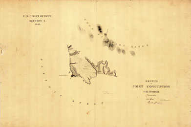 | | T-313, Point Conception, 1850 |
The T-Sheets were primarily for the internal use of the Coast Survey. Their major purpose was to be used to produce the cartography of the published maps and charts. Here is the first published map from the Survey's work in California.
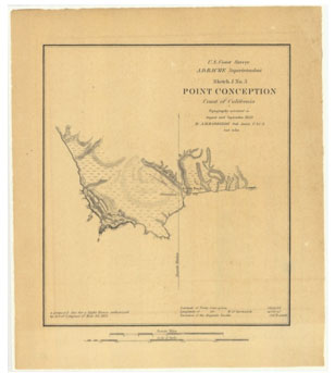 | | Sketch J3, Point Conception, 1850 |
Note that the two maps cover the same area, and are closely coupled, but they have different "names"-T-313 Point Conception and Sketch J3 Point Conception.
Below is the very first Coast Survey map of the Farallones, along with the opening of the Golden Gate.
 | | The North and South Farallones, and the Golden Gate, 1851 |
|